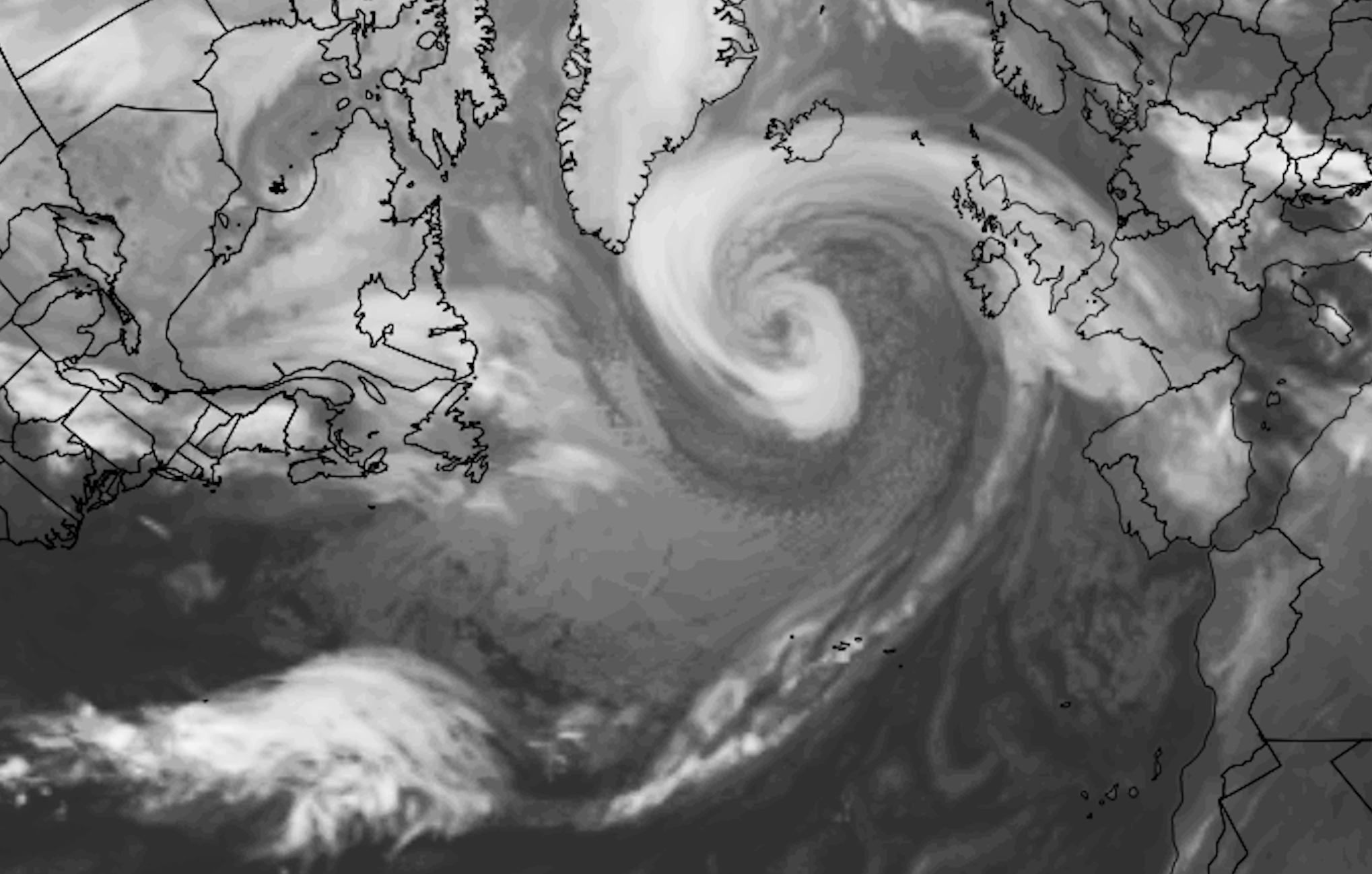
Hurricane Epsilon strengthened to a major hurricane today, and now has maximum sustained winds of 115 miles per hour according to the National Hurricane Center. The hurricane will pass east of Bermuda in the next few days before turning into the North Atlantic Ocean. Epsilon is the second straight major hurricane, following Hurricane Delta which moved into the Gulf of Mexico a few weeks ago.
https://www.nymetroweather.com/wp-content/uploads/2020/10/Screen-Shot-2020-10-21-at-7.05.44-PM.png12982038John Homenukhttps://www.nymetroweather.com/wp-content/uploads/2024/02/Empire-2000-x-300-px-2.pngJohn Homenuk2020-10-21 19:08:102020-10-21 20:35:16Epsilon could become a major North Atlantic storm next week
Briefing: Generally quiet weather is expected this week. Temperatures will warm well above normal as the week goes on with only a few chances of scattered showers on Tuesday. Pleasant weather will then return through the weekend. Tropical Storm Epsilon formed in the Atlantic this morning, continuing a record breaking hurricane season.
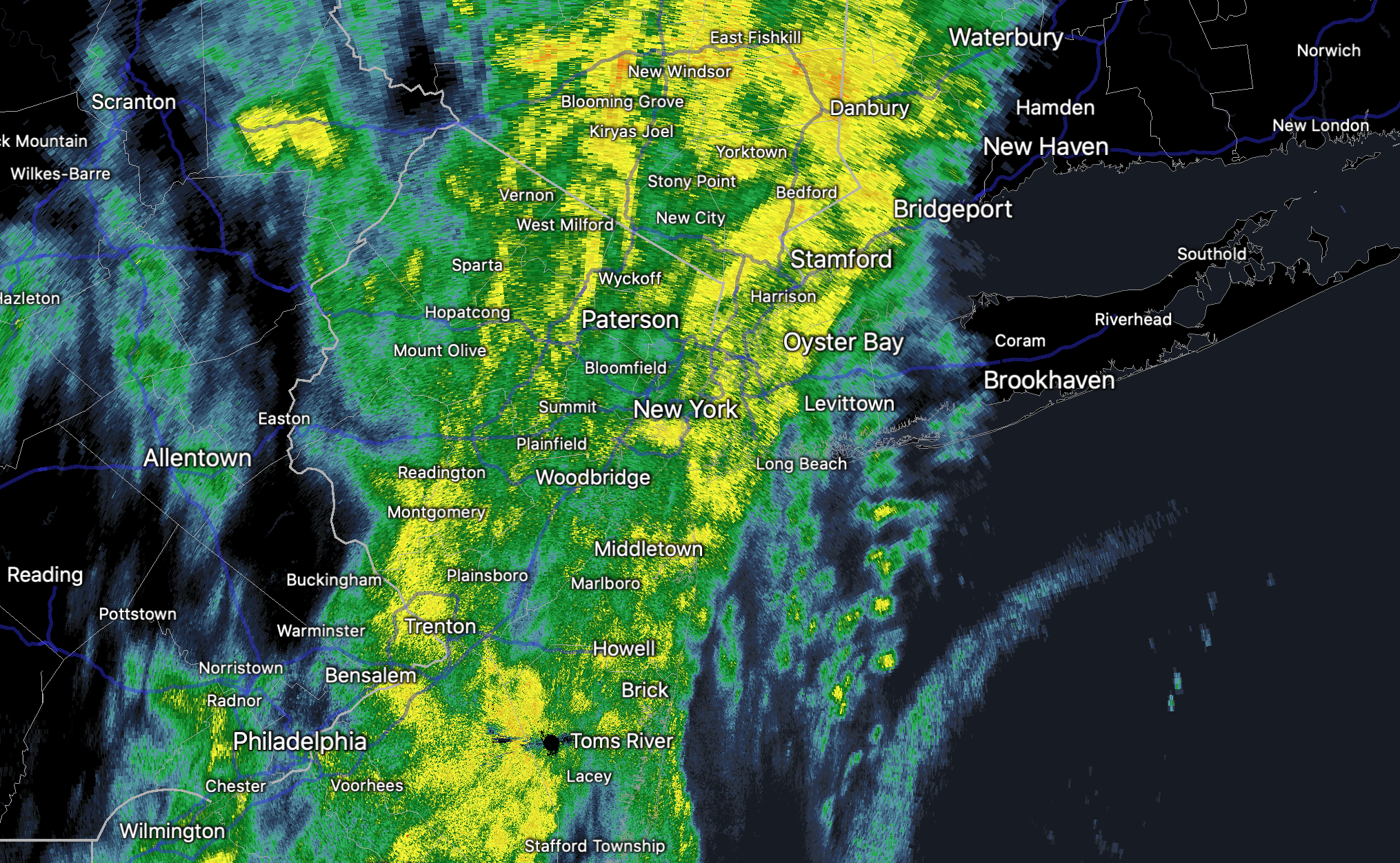
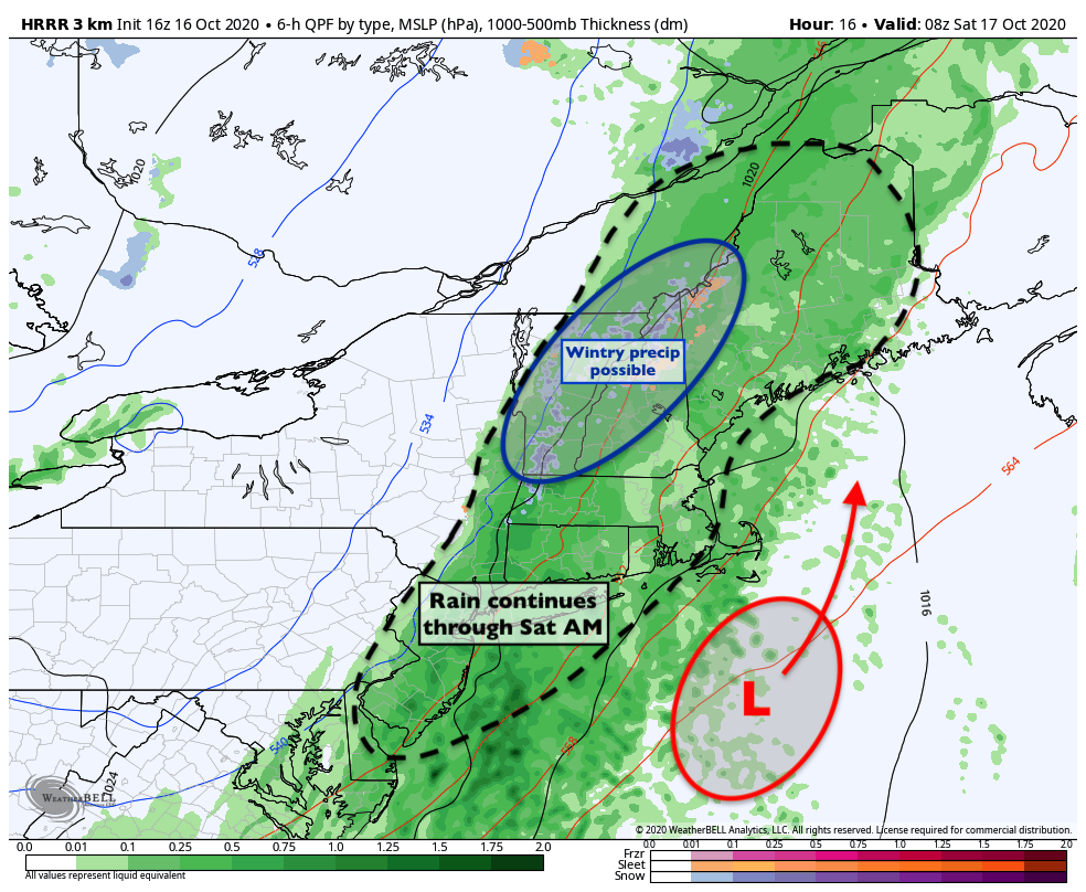
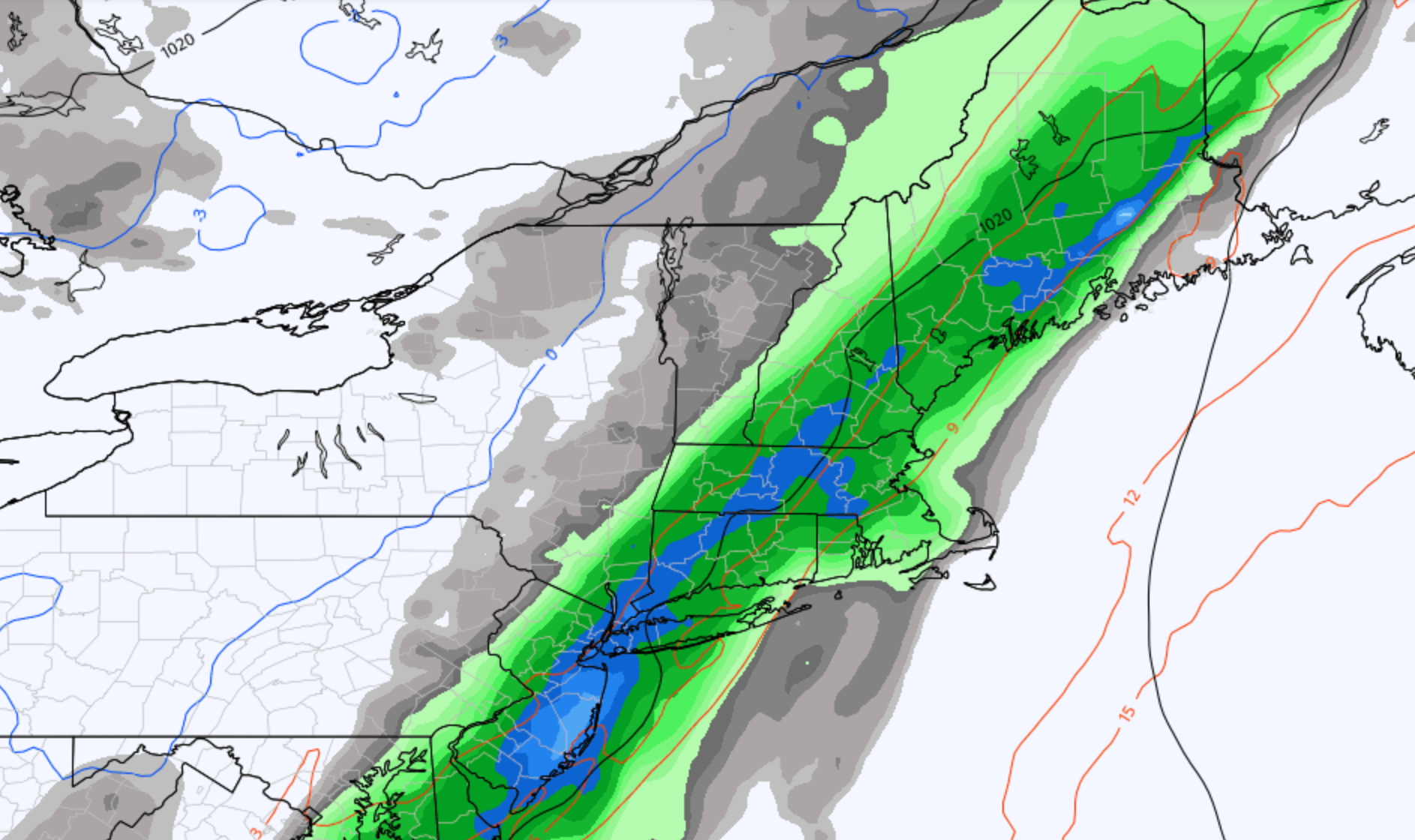
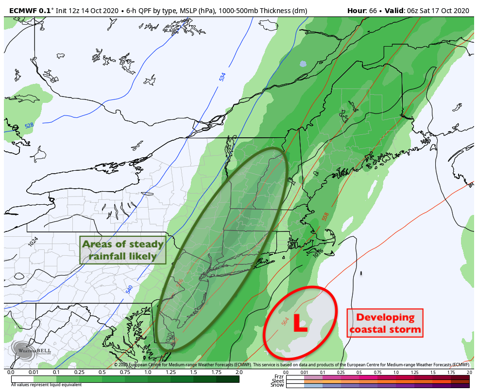
Briefing: Steady rainfall will persist for the next few hours, as a low pressure system develops off the New England coast. Periods of rain will continue into Saturday morning. Thereafter, improving conditions are likely for the remainder of the weekend.
NYC QuickCast
Tonight: Periods of rain continuing with dreary and cool conditions. Temperatures in the 50’s throughout the area.
Saturday: Rain in the morning hours, tapering off quickly with improving conditions throughout the day. Cool and blustery with highs only in the lower 60’s.
Sunday: Pleasant, cool and blustery with plenty of sunshine. Highs in the lower to middle 60’s.
Discussion: Frontal system brings rain today, better weekend with cool weather
Regional analysis this afternoon showed moisture pooling along a frontal boundary which is situated along the East Coast, conveniently right near the NYC Metro Area. A low pressure system is gradually developing off the coast and is expected to deepen near New England later tonight and Saturday. In the meantime, however, rainfall is expected to continue.
This afternoon and evening will likely be defined by dreary and gross conditions as a result. Short term models suggest the potential for an additional half-inch of rainfall as this system evolves. Once the deep low pressure develops in New England, drier air will be gradually pulled in from the west. This will shut down the rainfall and reduce moisture, with cooler and drier conditions taking over by Saturday morning.
The weekend looks likely to provide classic Autumn weather. Temperatures will top out in the lower 60’s, with a bit of a blustery westerly wind. There will be plenty of sunshine, with temperatures only a few degrees below normals for this time of year.
The pattern into next week becomes a bit more complicated. We’re closely watching the evolution of high latitude blocking, as well as keeping an eye on the tropics. Some guidance is suggesting the potential for the organization of a tropical system in the Southwest Atlantic as well as the Caribbean. Both of those areas will be monitored closely this weekend, though it’s far too early to determine what (if any) impacts those systems will have on our area’s weather.
https://www.nymetroweather.com/wp-content/uploads/2020/10/Screen-Shot-2020-10-16-at-2.06.33-PM.png12522030John Homenukhttps://www.nymetroweather.com/wp-content/uploads/2024/02/Empire-2000-x-300-px-2.pngJohn Homenuk2020-10-16 14:15:112020-10-16 14:15:17Weekend Forecast: Rain through tonight, improving this weekend
Briefing: Pleasant weather will continue for the next two days with high pressure in control. Another coastal storm will develop this weekend, with a strong low pressure developing off the coast of New England. Periods of heavy rainfall will occur in the NYC Area from Friday into Saturday morning. Clearing, but cooler weather is then likely this weekend.
Quick Forecast
Tonight: Mostly clear and calm. Lows in the middle 50’s with a light southwesterly wind.
Thursday (10/15): Mostly sunny and warmer, with highs in the mid 70’s. Light southerly winds.
Friday (10/16): Increasing clouds with showers likely late. Rain becoming heavy at times during the evening hours. Light southwest winds.
Discussion: Coastal storm develops this weekend with rain likely on Friday
The weather is expected to remain calm and pleasant for the next few days, with high pressure in control. This will lead to warmer than normal temperatures and calm conditions on Thursday. Temperatures will average several degrees above average on Thursday, with highs in the middle 70’s.
By Friday, the atmospheric pattern will amplify across the United States. This can be traced back to the presence of anomalous high latitude blocking in the Arctic. A deep trough and associated disturbance will move into the Ohio Valley and then amplify off the East Coast. Meanwhile, a frontal system will setup near the Mid Atlantic and Northeast states.
As the low pressure system begins to develop, the jet stream in the upper levels of the atmosphere will become increasingly amplified. This will allow for increased lift for precipitation, and rain is expected to develop on Friday afternoon and evening. Conditions will go downhill Friday night with continued showers and dreary weather.
One bit of good news will be the progressive nature of the storm. A coastal storm system is expected to develop near New England on Saturday, but it will be quick moving and will shift into Eastern Canada in short order. This will allow drier air to shift back into the region on Saturday, with improving conditions for the weekend.
Temperatures this weekend will average cooler than normal, with westerly winds in the wake of the developing storm system to our north and east. High temperatures on Saturday and Sunday are only expected to reach the lower 60’s.
Hi friends! Our website uses cookies to provide an optimal browsing experience for you. New "Cookie Consent" laws mandate us to inform you of this. As long as you're cool with it, just hit OK. You'll only see this message once.
We may request cookies to be set on your device. We use cookies to let us know when you visit our websites, how you interact with us, to enrich your user experience, and to customize your relationship with our website.
Click on the different category headings to find out more. You can also change some of your preferences. Note that blocking some types of cookies may impact your experience on our websites and the services we are able to offer.
Essential Website Cookies
These cookies are strictly necessary to provide you with services available through our website and to use some of its features.
Because these cookies are strictly necessary to deliver the website, refusing them will have impact how our site functions. You always can block or delete cookies by changing your browser settings and force blocking all cookies on this website. But this will always prompt you to accept/refuse cookies when revisiting our site.
We fully respect if you want to refuse cookies but to avoid asking you again and again kindly allow us to store a cookie for that. You are free to opt out any time or opt in for other cookies to get a better experience. If you refuse cookies we will remove all set cookies in our domain.
We provide you with a list of stored cookies on your computer in our domain so you can check what we stored. Due to security reasons we are not able to show or modify cookies from other domains. You can check these in your browser security settings.
Other external services
We also use different external services like Google Webfonts, Google Maps, and external Video providers. Since these providers may collect personal data like your IP address we allow you to block them here. Please be aware that this might heavily reduce the functionality and appearance of our site. Changes will take effect once you reload the page.
-2")