The sun will set in NYC at 5:53pm this evening, the last sunset after 5pm until late January of 2021. Daylight saving time ends tonight at 2am, and sunset on Sunday is at 4:51pm. Now that we’ve gotten that misery out of the way, let’s talk about the weather.
https://www.nymetroweather.com/wp-content/uploads/2020/10/Screen-Shot-2020-10-31-at-3.23.51-PM.png10481612John Homenukhttps://www.nymetroweather.com/wp-content/uploads/2024/02/Empire-2000-x-300-px-2.pngJohn Homenuk2020-10-31 15:33:062020-10-31 15:33:11NYC Forecast: More rain Sunday, much warmer weather late week
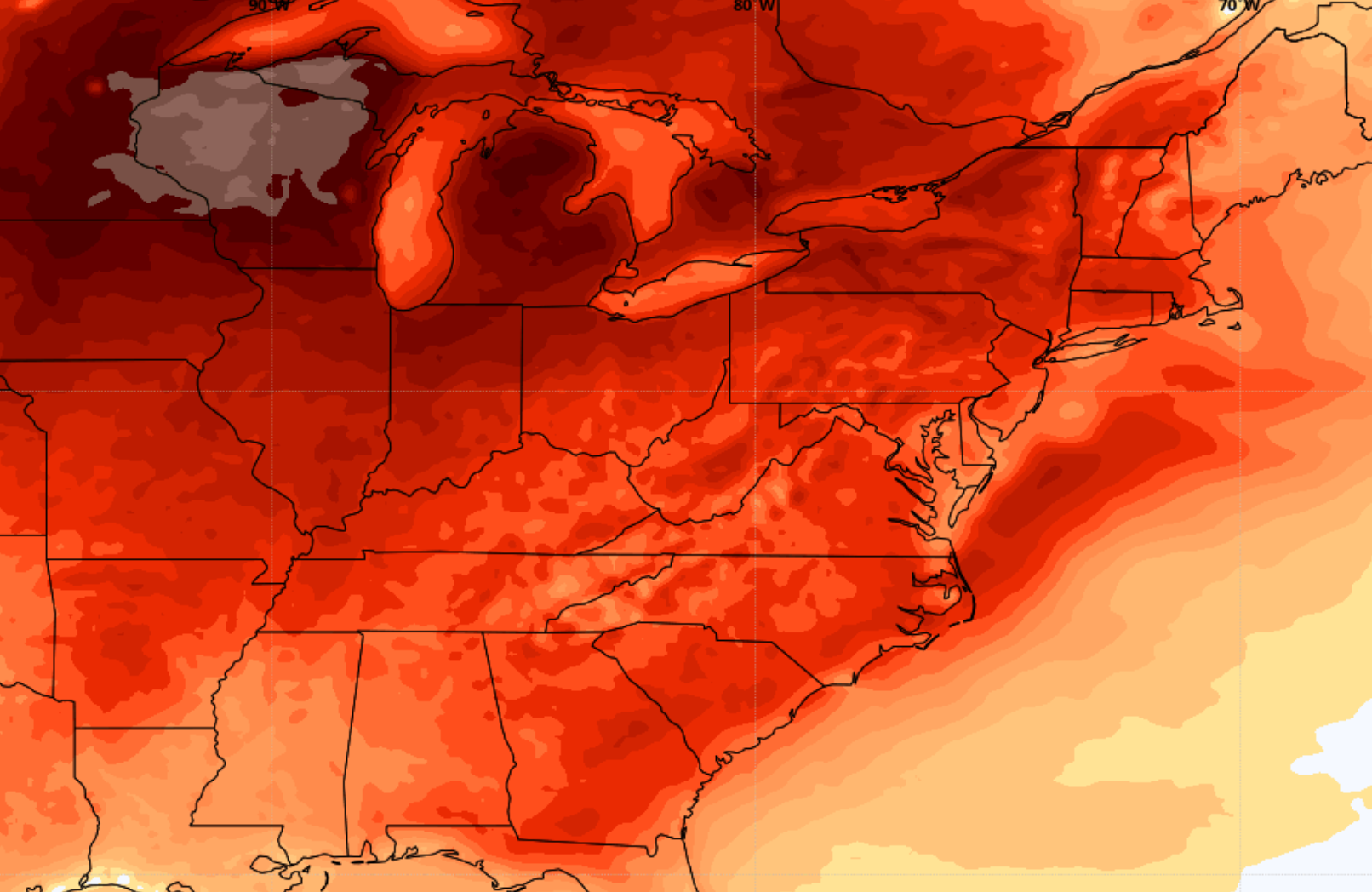
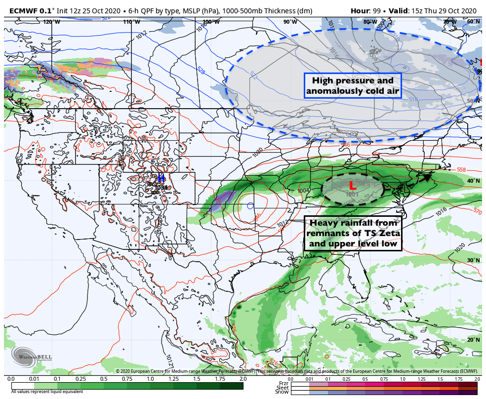
As fog and drizzle continues in the NYC Metro Area this afternoon, the weather pattern to our west is becoming increasingly amplified and active. This includes record-breaking cold in the Plains and Tropical Storm Zeta in the Caribbean. Later this week, the two disturbances could phase and result in an impressive Nor’Easter.
https://www.nymetroweather.com/wp-content/uploads/2020/10/Screen-Shot-2020-10-26-at-3.17.09-PM.png10401646John Homenukhttps://www.nymetroweather.com/wp-content/uploads/2024/02/Empire-2000-x-300-px-2.pngJohn Homenuk2020-10-26 15:23:232020-10-26 15:23:29Coastal storm could bring myriad of weather hazards late week
Did you miss the fog, drizzle and low clouds? We have great news! They are all set to return to the forecast in NYC this week. Showers and dreary weather are expected almost every day beginning on Monday. Multiple rounds of low pressure will bring additional rainfall to the area through Thursday, with fog and dreary conditions in between.
The forecast is quite complicated, and driven by multiple disturbances embedded within the atmospheric flow. This results in a low confidence forecast overall, as model guidance struggles with the timing and intensity of individual perturbations. Still, there is a good bit of certainty that the week will be unsettled and unpleasant as a whole.
Showers start Monday as a weak coastal low forms
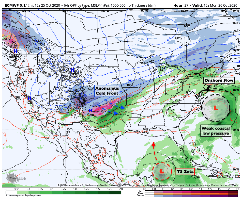
Forecast surface map for Monday. A coastal low will provide unsettled conditions in the NYC Area.
The trouble begins on Monday when a weak low pressure system forms off the Mid Atlantic coast. Low pressure is expected to develop gradually, with an onshore flow developing during the morning and afternoon hours. This will lead to a thick deck of stratus clouds. Moisture in the low levels of the atmosphere will lead to drizzle and some fog in addition to scattered showers.
Temperatures will also remain quite raw – with highs expected to reach only the lower 60’s. Cool and damp winds out of the northeast will be persistent from the morning hours of Monday into the overnight period and Tuesday morning. The coastal storm will gradually shift northeast of the area on Tuesday.
All of this is occurring while an anomalous cold front is surging southward into the Plains states. Temperatures there will reach 30 to 40 degrees below normal in spots, with widespread winter weather. Meanwhile, Tropical Storm Zeta will move towards the Yucatan on Monday and then into the Gulf of Mexico. These two features will become keys to the forecast in the NYC Area later in the week.
Zeta and upper low will lead to midweek trouble
Tropical Storm Zeta will move northward into the Gulf of Mexico this week, eventually making landfall along the Central Gulf Coast. Moisture from the system will surge northward into the Tennessee and Mississippi River Valley by Wednesday and Thursday.
Meanwhile, the upper level system bringing anomalous cold and snow to the Plains will begin to shift eastward. Zeta will interact with this system, and impressive atmospheric dynamics will allow for areas of steady and heavy rain to expand northward. These rains will move into the Tennessee and Ohio Valleys first, and then gradually shift towards the Northeast and Mid Atlantic States.
Wednesday will be the one potential “winning” day of the week. We’ll be in between storm systems, with weak high pressure building in. While some fog and drizzle is possible in the morning, the majority of the day is expected to remain dry.
By later this week, ensemble guidance is in great agreement that areas of heavy rainfall will move into NYC once again. A new low pressure area will develop in the Ohio Valley, and baroclinicity will be enhanced between the developing low pressure and a strong high pressure to its north. This could lead to periods of heavy rain in the NYC Area on Thursday.
Winter weather possible in New England late this week
As the low pressure center begins to shift eastward, ensemble guidance is in good agreement that anomalously cold air will begin to seep southward from Canada. On Friday, the potential exists for the redevelopment of a coastal low pressure off the coast of New England.
Forecast surface map for Friday. Winter weather is possible in New England.
The combination of the cold air seeping southward and the developing coastal storm system opens the door for winter weather potential in New England. Much of the threat will be modulated by how strong the storm system becomes – in other words, will it be amplified enough to send moisture and precipitation into the cold air in New England?
Latest runs of the ECMWF and ECMWF Ensemble seem to think so. Folks in Northern New England, particularly Central and Northern New York, Vermont and New Hampshire should have their eyes peeled for some wintry precipitation on Friday.
Eventually, this system will slide off the New England coast and all regional meteorologists will exhale and pour themselves a crisp drink for the weekend – which, as it stands now, is expected to be quite pleasant.
https://www.nymetroweather.com/wp-content/uploads/2020/10/antoine-meillet-FSAC8EQEeNE-unsplash-scaled.jpg16962560John Homenukhttps://www.nymetroweather.com/wp-content/uploads/2024/02/Empire-2000-x-300-px-2.pngJohn Homenuk2020-10-25 17:54:222020-10-25 17:57:27NYC Forecast: Active, unsettled weather in the week ahead
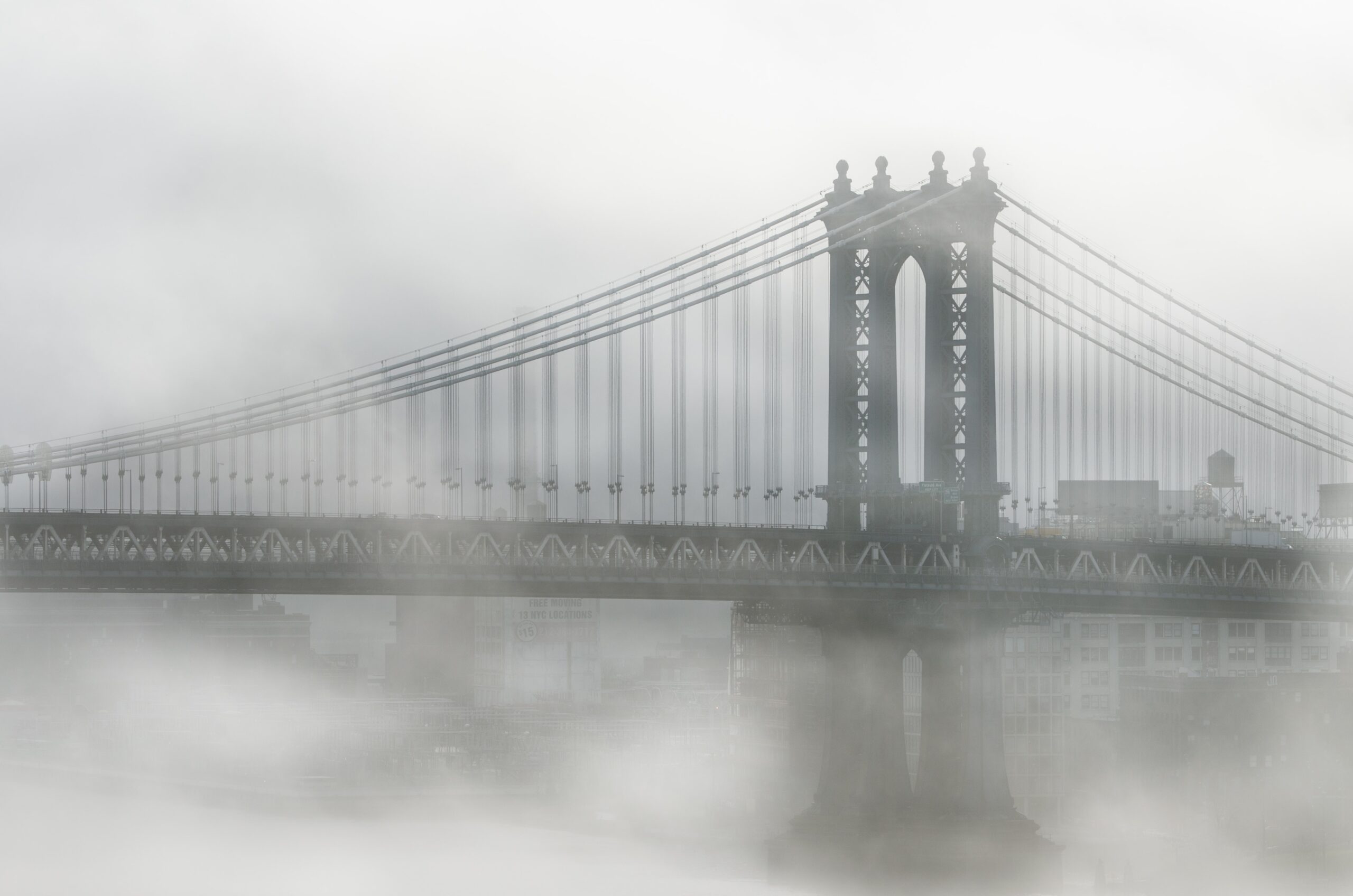
Fog has settled in to the area again today, and is expected to gradually lift this afternoon. It has been slow to do so, but some breaks in the clouds have been observed on visible satellite imagery. Unseasonably warm and humid weather will follow once the clouds break, with high temperatures in the lower 70’s. The fog will return tonight, with dreary and showery weather on Friday.
Fog has been the word of the week, with temperature inversions developing each morning and plentiful moisture leading to widespread low clouds. This afternoon will be a bit of an anomaly, as warmer temperatures and slightly drier conditions in the low levels of the atmosphere will allow for clearing.
Short term forecast models are struggling (big shock there) to properly handle the degree of low clouds. As a result, temperature forecasts are fluctuating by several degrees. Still, the expectation is that high temperatures will reach into the upper 60’s and lower 70’s by Thursday afternoon, especially Southern New Jersey as well as the urban corridor from Newark to NYC.
NYC QuickCast
Tonight: Warm and pleasant to start, increasing clouds by the mid evening hours. Low temperatures in the lower 60’s with areas of drizzle.
Friday: Foggy and dreary with areas of drizzle. Clearing is less likely than days prior. Highs in the mid 60’s with light easterly winds.
Saturday: Foggy and drizzly conditions early, improving by late morning. Highs near 70 with partly cloudy skies in the afternoon hours.
Sunday: The nicest day of the past few, but notably cooler. High temperatures only reaching the upper 50’s with a westerly wind direction.
How can we forecast the development of fog?
There are several ways for fog to develop. One of the most important things to know is that fog is a type of low cloud – very close to the surface. It is technically defined as a visible aerosol, containing tiny water droplets or sometimes ice crystals.
Forecasting fog can often be quite difficult, as it is heavily modulated by local geography. For instance, fog can develop more frequently near the ocean or bodies of water but often has trouble pushing over higher elevations or mountains. As you might imagine, this creates complications for fog forecasts in our local area (how far inland will fog move, etc).
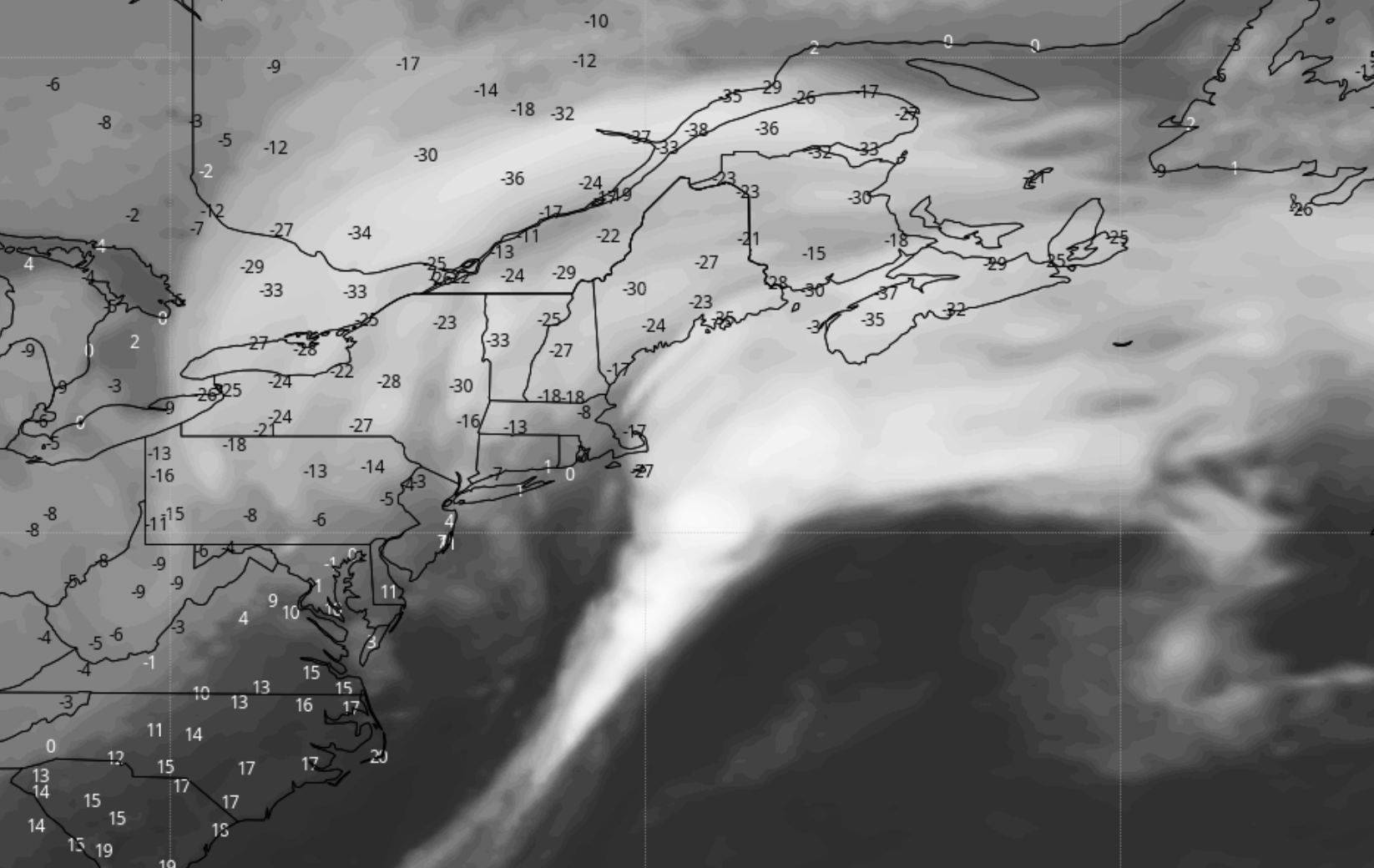
Over the past few days, the forecasts for fog to develop during the evenings has been fairly easy. The forecast sounding pictured above shows a classic fog profile. There is a temperature inversion (rising temperature with height), plenty of low level saturation and moisture, and very light winds. In this situation, fog will almost always develop.
Forecast soundings throughout the area have this same “look” later tonight and Friday morning, as well as Saturday morning, with lots of moisture in the low levels and inversion to trap it there. As a result, we anticipate the development of more fog on both nights.
https://www.nymetroweather.com/wp-content/uploads/2020/10/valou-_c-U7ExImpZMME-unsplash-scaled.jpg17072560John Homenukhttps://www.nymetroweather.com/wp-content/uploads/2024/02/Empire-2000-x-300-px-2.pngJohn Homenuk2020-10-22 10:47:022020-10-22 14:09:09NYC Forecast: Pushing through the fog
Hi friends! Our website uses cookies to provide an optimal browsing experience for you. New "Cookie Consent" laws mandate us to inform you of this. As long as you're cool with it, just hit OK. You'll only see this message once.
We may request cookies to be set on your device. We use cookies to let us know when you visit our websites, how you interact with us, to enrich your user experience, and to customize your relationship with our website.
Click on the different category headings to find out more. You can also change some of your preferences. Note that blocking some types of cookies may impact your experience on our websites and the services we are able to offer.
Essential Website Cookies
These cookies are strictly necessary to provide you with services available through our website and to use some of its features.
Because these cookies are strictly necessary to deliver the website, refusing them will have impact how our site functions. You always can block or delete cookies by changing your browser settings and force blocking all cookies on this website. But this will always prompt you to accept/refuse cookies when revisiting our site.
We fully respect if you want to refuse cookies but to avoid asking you again and again kindly allow us to store a cookie for that. You are free to opt out any time or opt in for other cookies to get a better experience. If you refuse cookies we will remove all set cookies in our domain.
We provide you with a list of stored cookies on your computer in our domain so you can check what we stored. Due to security reasons we are not able to show or modify cookies from other domains. You can check these in your browser security settings.
Other external services
We also use different external services like Google Webfonts, Google Maps, and external Video providers. Since these providers may collect personal data like your IP address we allow you to block them here. Please be aware that this might heavily reduce the functionality and appearance of our site. Changes will take effect once you reload the page.
-2")