-2")

A message regarding COVID-19 (Coronavirus)
New York Metro Weather is a weather website first, and will always remain that way. Our main goal and focus will always be to provide accurate, reliable weather forecasts. We are not doctors, biologists, or virologists and we will not claim to be experts on how to handle this ongoing situation. With that being said, we have received questions regarding coronavirus procedures and decided it was in our best interest to provide some thoughts on how to best proceed.
Meteorologists and emergency managers are used to functioning in these types of situations, and communication is essential. One of the most important issues we face before almost every major weather event is confusion regarding what to do. This is why we always try to simplify our message so that everyone can understand it. We will try to continue these same practices here. Let’s start with this very important fact:
We are taking COVID-19 (coronavirus) very seriously. You should be doing exactly the same thing.
What is COVID-19 (Coronavirus)?
Coronavirus disease 2019 (COVID-19) is a respiratory illness that can spread from person to person. The virus that causes COVID-19 is a novel coronavirus that was first identified during an investigation into an outbreak in Wuhan, China. COVID-19 can be spread from person to person quite easily.
The virus is thought to spread mainly between people who are in close contact with one another (within about 6 feet) through respiratory droplets produced when an infected person coughs or sneezes. It also may be possible that a person can get COVID-19 by touching a surface or object that has the virus on it and then touching their own mouth, nose, or possibly their eyes.
Symptoms can vary, but often include pneumonia in both lungs, multi-organ failure and in some cases death. For more information on COVID-19 from the World Health Organization, please read this one-page briefing.
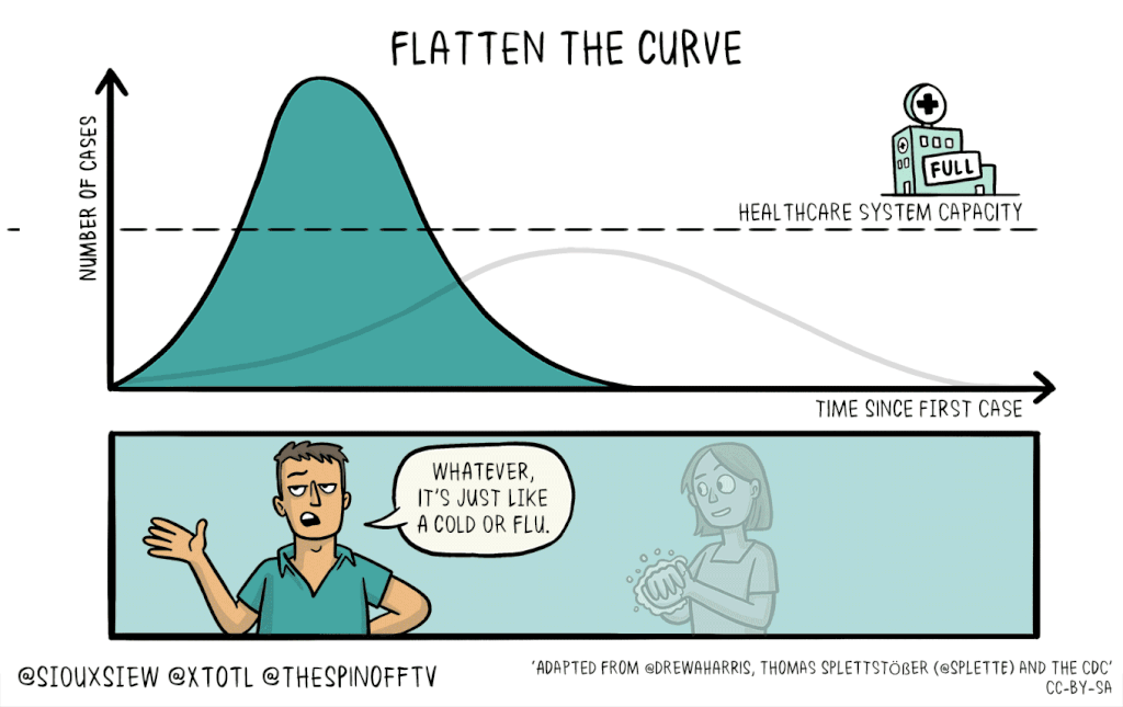
The importance of social distancing
Social distancing is likely the best, most effective and proven tool in reducing a full-blown outbreak of COVID-19 by reducing the spread from person to person. This is the exact reason why sports have been suspended, why many schools have been closed, and why mass gatherings are being reduced and/or prevented.
Make no mistake about it – these are the right decisions. This is not panic, nor is it fear mongering or overreaction. It is exactly what is required in order to stop the rapid spread of COVID-19. However, further steps need to be taken beyond things like sports or mass gatherings, and they involve you.
That’s right, you need to step up too.
Social distancing in your daily life involves things like staying at home as much as possible and keeping 6 feet of distance between you and others when you can. It involves making the smart decisions and not going out to crowded restaurants, bars or mass gatherings and events. These things won’t necessarily be easy to accomplish, and are certainly disruptive to the life we have grown accustomed to.
But social distancing is critically important. This is especially true in a place like New York City, where on a typical day we come into close contact with hundreds, if not thousands of people. It is time to be smart about this – because if we are not, COVID-19 spread could become very, very problematic right in our very own backyard. For more on social distancing practices, please see this article from The Atlantic.
Stick to the essentials
Let us be the first to tell you: You do not need to buy pounds of toilet paper.
One of the biggest problems we face as society during major or disruptive events is the hoarding of certain items. Before every major snowstorm, NYC Metro Area shelves are bare from those who decide to buy bread and milk. Now, as COVID-19 reaches the United States, people have decided it is time to purchase inordinate amounts of toilet paper.
When you go to buy food or supplies, please buy only what you need. Buying mass quantities of items such as toilet paper, bread, milk or water is selfish. It leaves supplies for everyone else and causes problems with restocking and resupplying at the grocery story. Do not hoard items.
Be kind, take care of each other
While social distancing is something we must all become comfortable with, it’s equally as important that we take the time to help out the people around us. It’s important to remember that everyone reacts to these situations differently. For many of us, this is one of the most disruptive periods in our lives so far.
Check on your neighbors and friends. Touch base with people who you know may have a more difficult time getting outside and obtaining supplies (the disabled or elderly, for example). Most importantly, be patient with people and try to understand different perspectives on the ongoing situation.
Finally, take some time to appreciate those around you. There are emergency managers doing very important work, workers stocking the shelves of your grocery stores and small businesses that are suffering because of the ongoing COVID-19 measures. Buy a gift certificate to your favorite restaurant to use later on. Say thank you to the kind woman who is restocking the cheese on Isle 4 at Trader Joes.
Ultimately, the only way to get through this effectively is if we do it together. Be smart, be kind, and do everything that you can to help. There is no place better at dealing with moments like this than New York City. It’s time for us all to step up.