-2")
Winter storm could impact NYC early next week
Confidence is increasing that the NYC Area will be impacted by a coastal storm, which is forecast to develop off the Mid-Atlantic coast early next week. Uncertainty still exists regarding the exact details of the systems evolution and resulting impacts, but a significant winter storm is a distinct possibility.
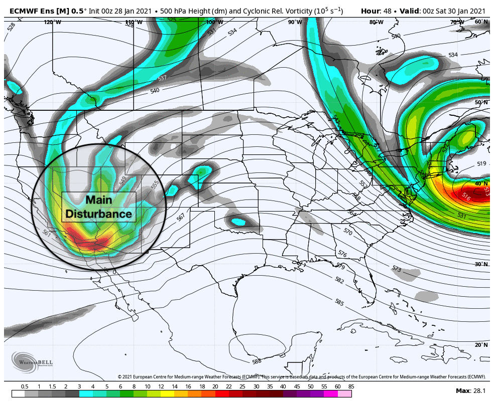
The disturbance responsible for the development of the storm system is still coming ashore in the Western United States today. Confidence in the systems eventual track and intensity should begin to increase in the next 24-36 hours, as the main pieces responsible for the storm threat come in to better focus.
How is this storm forming over the next few days?
The origins of the storm threat early next week can be traced back to a Pacific disturbance currently coming ashore in the Western United States. This disturbance is forecast to eject eastwards towards the Rocky Mountains over the next few days, and will eventually emerge into the Central Plains states early this weekend.
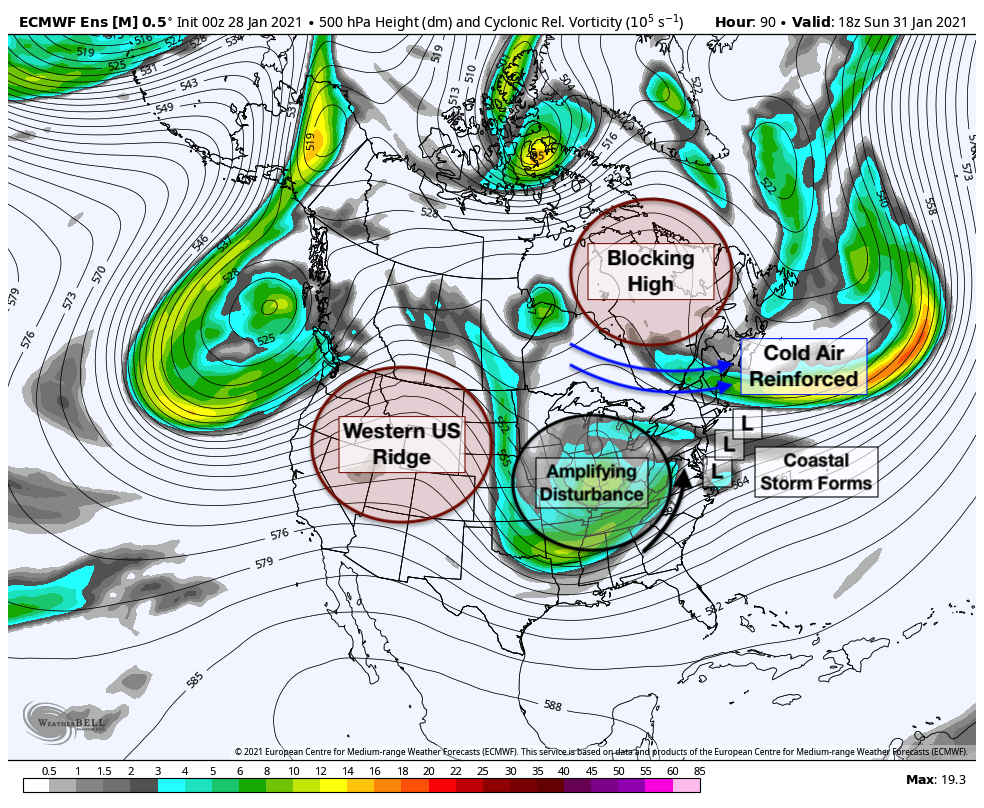
As this system moves eastward toward the Ohio Valley, it is forecast to amplify and strengthen. The storm will be forced underneath a high latitude block, or -NAO, which is present over Southeast Canada. These blocks are notorious for slowing down “traffic” in the atmosphere and resulting in impactful winter weather events in the Northeast states. The high latitude block also ensures that there will be plenty of cold air in place as the storm approaches.
The amplifying storm system and jet dynamics aloft will aid in the development of a low pressure system, which will move into the Ohio Valley. This same low pressure system will be forced to redevelop offshore by the aforementioned block, with a new low pressure center developing off the Mid-Atlantic coast. This will allow snow to spread into the Mid-Atlantic and New England on Monday.
As the system amplifies in the Ohio Valley, a second disturbance is forecast to phase (or merge) into the system near the Mid-Atlantic coast. This phase opens the door for rapid intensification of the surface low while it is off the coast of the Mid-Atlantic states. Should this phase occur, the storm could strengthen – and stall, as its northward movement is still restricted by the blocking high.
Eventually, the system will elongate and pull northeastward into the Atlantic. If the amplification and phasing are timed properly, the potential exists for a long duration and high impact winter storm somewhere in the Mid-Atlantic and Northeast states.
What makes this threat more notable than others?
There are several winter storm threats every year, and the majority of them fall into the category of “moderate” or “slight” in terms of potential impact. Most of our winter storms in the NYC Area during the past few winters have fallen into this category, with slight to moderate impacts (the same cannot be said for the interior, but that’s a discussion for another day).
Every few years, a more notable threat comes around – one that draws the attention of meteorologists and rings a few extra alarm bells. That’s this storm. The synoptic pattern suggested by ensemble guidance is highly anomalous and checks several of the boxes that we often look for when considering a high impact winter weather event.
Furthermore, despite being unique in its own right, = the evolution of this system is at least a loose match to many notable winter storm events of the past – specifically in the NYC Metro Area. Yesterdays GFS-based analog guidance, for example was littered with historic Northeast winter storms from the past two decades.
Synoptically, the development and evolution of this system strongly favors a significant winter weather event. A large disturbance amplifies in the Ohio Valley thanks to a building ridge on the West Coast. A blocking high forces the redevelopment of a coastal storm and reinforces cold air. A second disturbance phases in and kickstarts a strengthening coastal low pressure.
Still, despite the growing confidence that a significant event will occur, we are left with many questions.
What are the uncertainties moving forward and how do we monitor them?
There is still a great deal of uncertainty regarding how this storm system will evolve as it moves into the Mid-Atlantic and Northeast states early next week. While general agreement exists among ensembles, there are still impactful differences in regards to the storms evolution.
The differences can mostly be traced back to the synoptic setup as a whole, and how the model guidance handles key features. For example, ensemble guidance that is stronger with the blocking and cold air to the north are generally more suppressed or further south with the storm.
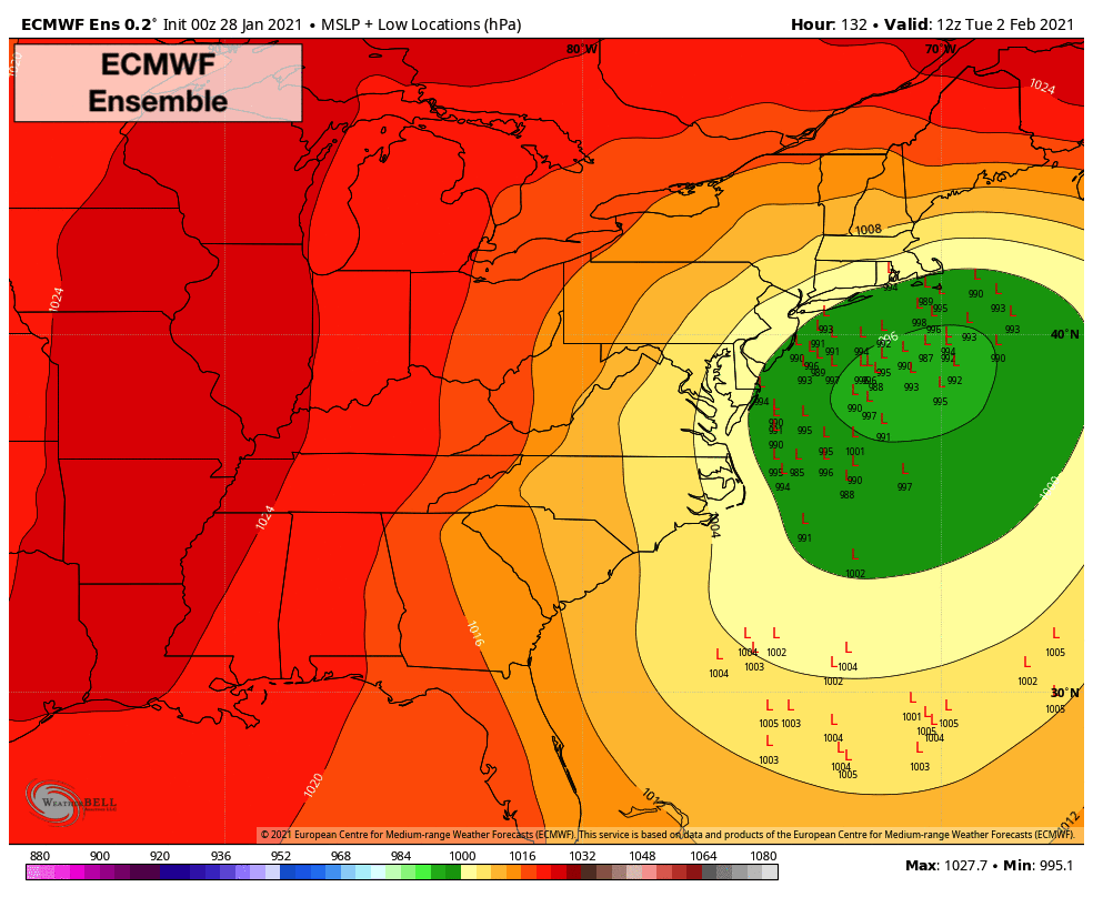
The ECMWF Ensemble is more amplified with the system overall. The disturbance is more amplified as it approaches the coast, and the second disturbance phases in more cleanly, leading to a more meridional (south-to-north) alignment of the height field along the coast. Accordingly, the developing coastal low tracks closer to the shoreline.
The GFS Ensemble still signals an impactful storm system, but is less amplified and allows the storm system to track slightly further east. The height field is slightly less meridional and the surface low development is further south and east of the ECMWF Ensemble as a result.
Some ensemble members on both the ECMWF and GFS suites show solutions varying from a complete miss to a storm that hits inland areas and mostly misses the I-95 corridor with heavy snow. While these are not favored solutions at this time, they are still options.
The main point to drive home here? There is still a lot to figure out. Exactly how each of the key features mentioned above evolves will help modulate the sensible weather impacts from this system. Until we get a bit closer to the event (24-36 hours from now) our confidence will inherently be lower in regards to where the most notable impacts will be.
What is the current threat level and what are the anticipated impacts?
Given all of the information discussed herewith, we have maintained the risk level for winter weather impacts to Enhanced (2/4) across the majority of the NYC Metro Area. This risk level means that winter weather impacts are becoming increasingly likely, and if the threat does materialize travel disruptions could be widespread and impactful.
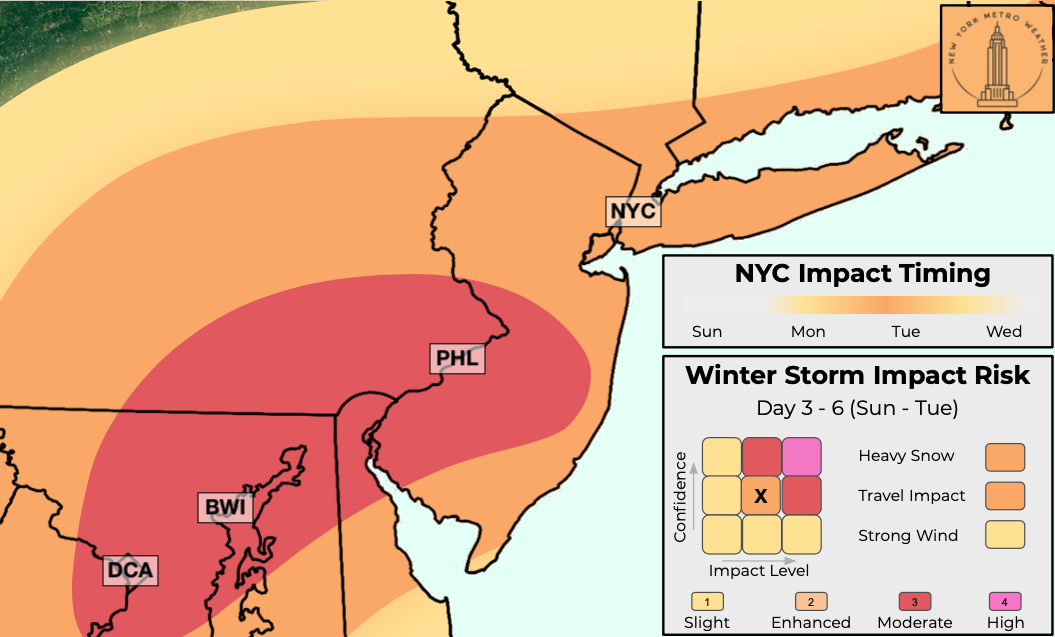
Snow is expected to begin early Monday across the Mid-Atlantic and Northeast states and will spread from southwest to northeast through PA and NJ. A coastal low will develop offshore and, depending on how the system forms and develops, heavier snow could spread northward into NJ, NYC and New England from Monday evening into Tuesday morning. Depending on the track of the system, snow could linger into Tuesday evening.
Confidence in regards to accumulations is still extremely low, but the potential does exist for a significant snowfall in parts of the area. We will begin to hone in on the anticipated impacts and accumulations in the coming days.
Hey there, You have done an incredible job. I’ll definitely digg it and personally recommend to my friends. I am confident they will be benefited from this site.