-2")
Significant snow expected in NYC starting Sunday evening
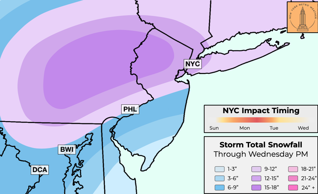
A severe winter storm is expected in the NYC Metro area from Sunday evening through Tuesday, with significant snowfall over 12″ likely. Periods of heavy snow, plus gusty northeast winds will lead to low visibility. Travel will be very difficult on Monday. Snowfall totals may exceed 10″ by the time the storm ends on Tuesday.
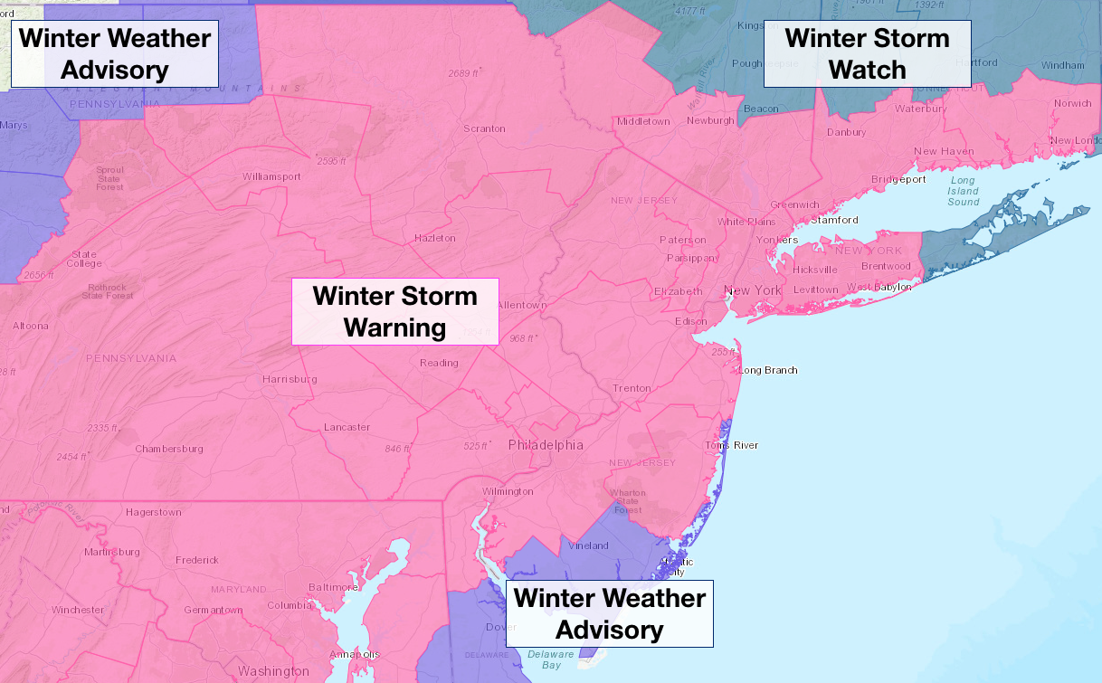
The National Weather Service has issued a Winter Storm Warning for a large majority of the urban corridor from Washington, D.C to New York City from Sunday through Tuesday. A Winter Storm Warning means that winter weather conditions are likely and will cause hazardous weather conditions. In our local area, it means there is high confidence in over 6″ of snowfall..
A Winter Weather Advisory is in effect for parts of N PA and SE NJ, where snowfall is anticipated but impacts are expected to be less significant. The NWS may choose to upgrade parts of the area to a Blizzard Warning where winds will consistently reach 40mph and heavy snowfall is anticipated.
How is the storm system forming?
The origins of the developing storm can be traced back to a Pacific disturbance, which recently came ashore in the Western United States. This disturbance moved eastward through the Rocky Mountains, and is just now emerging into the Central United States.
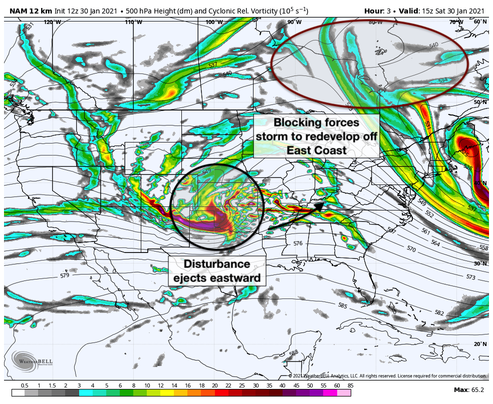
As this system moves eastward toward the Ohio Valley, it is forecast to amplify and strengthen. The storm will be forced underneath a high latitude block, or -NAO, which is present over Southeast Canada. These blocks are notorious for slowing down “traffic” in the atmosphere and resulting in impactful winter weather events in the Northeast states. The high latitude block also ensures that there will be plenty of cold air in place as the storm approaches This same low pressure system will be forced to redevelop offshore by the aforementioned block, with a new low pressure center developing off the Mid-Atlantic coast. This will allow snow to spread into the Mid-Atlantic and New England on Monday.
Eventually, the system will elongate and pull northeastward into the Atlantic. Given the strengthening storm system and long duration of its impact in our area, confidence has risen that a high impact winter storm will affect the NYC Metro.
What uncertainties still exist and what has changed in the past 24 hours?
Forecast model guidance has come into much better agreement regarding the eventual track and intensity of the storm system. The GFS, Euro and Canadian ensembles all agree that a low pressure system will move northward off the Mid-Atlantic coast before redeveloping to the north and east, south of New England.
The main uncertainty at this time revolves around the placement of the heaviest bands of snow, and where they set up for the longest period of time. Obviously, this will impact the areas that receive the heaviest snowfall and the most notable impacts from the storm system. Each ensemble differs slightly with their ideas on where the bands will set up.
The Canadian, for example, suggests that the band will rotate onshore and impact NYC before continuing inland. This would bring significant snowfall to the NYC Metro, but lead to a higher impact event across the interior. The Euro and GFS, however, suggest the band of heavy snow will slow and stall closer to NYC for a longer period of time, leading to higher impacts and heavier snowfall in the NYC Metro and surrounding parts of NJ and PA.
Our forecast currently takes a blend of the model suites, and accounts for the possibility of oscillating bands of heavy snow – some pushing inland, and others redeveloping near the NYC Metro area. With this forecast, we are confident in significant snowfall in the NYC Metro and surrounding areas, as well as further inland in parts of NE PA, SE NY and NJ. Confidence is lower near the coastal plain, where warmer air and a dry slot may work in for periods of time during the storm.
Snowfall forecast and details
Our current forecast takes a blend between the major ensemble suites, with a slight lean towards the European model guidance. This leads to a high confidence forecast of 12-15″ in the NYC Metro area and higher amounts further west. We have laid out the anticipated timing of impacts below:
Sunday 9:00pm: Bands of moderate snow are likely to begin working northward through Southeast PA, Southern and Central NJ. These bands will gradually approach the NYC Metro from the southwest. Accumulations should occur rather quickly as the intensity of snowfall begins to pick up.
Monday 3:00am: Snow will increase in intensity across Central and Northern NJ as well as the NYC Metro and surrounding areas. Visibility should drop during this time and accumulations will continue.
Monday 9:00am: Heavy snow is expected across the NYC Metro, Northern NJ, Eastern PA and surrounding areas. Winds will begin to ramp up as the coastal low forms. Visibility will drop and travel will be difficult.
Monday 3:00pm: The storm will likely be reaching or passing its peak intensity around this time. Bands of very heavy snowfall are likely in Northern NJ, Southeast NY and the NYC Metro area. Strong northeast winds are likely. Low visibility is anticipated. Travel will be very difficult.
Monday 9:00pm: Light to moderate snow will persist, but intensity will be lower. Northeast winds will continue to produce low visibility and travel may still be difficult.
Tuesday 1:00am: Light snow may continue in some areas, but the storm will finally begin to wind down during this time frame.
The forecast is still subject to change and is likely to be adjusted over the next 12 to 24 hours. As mentioned, there are still several key pieces to the storms evolution that are uncertain, and may result in shifts and adjustments to both the timing and location of heaviest snow.
With that said, confidence is high that a significant snowfall is on the way for the NYC Metro from Sunday into Tuesday. Let it snow!
baran aydin
baran aydin
türk kahvesinin faydaları
I like the valuable info you provide in your articles. I will bookmark your weblog and check again here regularly. I’m quite sure I will learn many new stuff right here! Best of luck for the next!
hurdacı firmalar içinde lideriz. En yakın hurdacı telefonu olan numaramızdan ulaşabilirsiniz. Hurda satmak için hemen arayın.