-2")
Winter Storm Watch issued for NYC as more snow looms
The National Weather Service issued a Winter Storm Watch for the NYC Metro Area and surrounding areas, effective from Thursday through Friday. Another winter storm will impact the area starting Thursday morning, and could bring significant snowfall to much of the area. The storm system is expected to linger in the area until Friday afternoon before pulling away.
Storm setup and dynamics
A low pressure system is forecast to develop in the Southeast states late Wednesday into Thursday, with moisture spreading northward into the Mid Atlantic States. In the mid levels of the atmosphere, a deep trough over the Central United States will shift eastward and de-amplify.
A piece of the polar vortex lingering over Southeast Canada will play a major part in the wintry potential for our area. This feature will act as a traffic stop of sorts, blocking the northward advancement of warm air that could have otherwise led to a storm that was more wet than white.
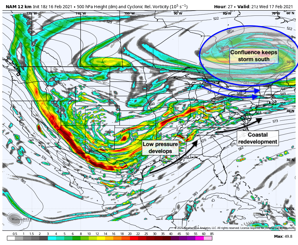
Instead, this feature will force the development of a surface low off the coast and keep a high pressure locked in place to our north. Cold air will seep southward, allowing precipitation to begin as all snow. Some mixing may move northward into the area as the storm passes by, but additional snow is expected as the low pressure develops offshore. The system will linger off the coast on Friday before finally meandering east away from the area.
A favorably positioned and strong upper level jet stream will help to enhance divergence aloft, expanding precipitation well away from the surface low pressure. The combination of a temperature gradient, moisture and lift aloft, plus the impressive jet dynamics suggests that precipitation with this storm could be expansive and heavy in some locations.
Impacts and timeline
The storm system will impact the area from Thursday through Friday, and some snow may linger in the area through Saturday morning before the system fully clears out.
Thursday
Snow will develop from southwest to northeast through the Mid Atlantic states and towards Pennsylvania, New Jersey and the NYC Metro. By late morning and early afternoon, moderate to heavy snowfall is possible across the entire area.
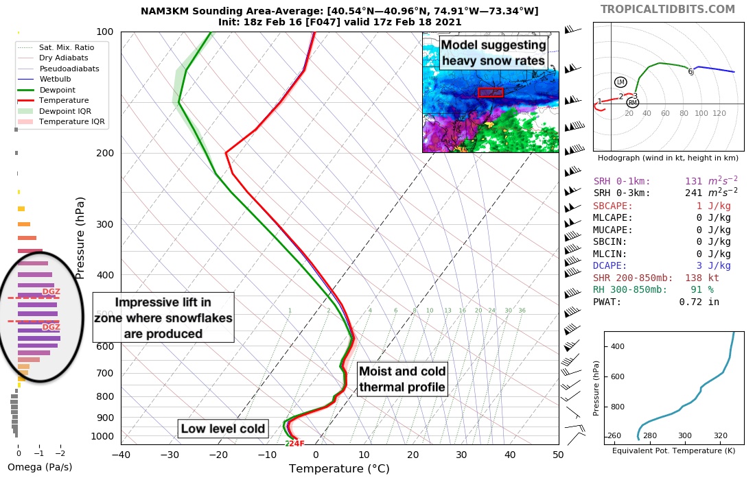
Forecast model soundings throughout the area suggest the possibility that a specific band of very heavy snow may progress northward into New Jersey and New York City during the early afternoon hours on Thursday. Soundings (pictured) show very impressive lift in the dendritic growth zone. This means that the atmosphere will be producing snowflakes with excellent efficiency. Dendrites also accumulate more efficiently – suggesting heavy, accumulating snow during this time.
The evening commute on Thursday currently looks, well – terrible. Periods of heavy snow and low visibility are expected and travel is likely to be very difficult in Northern New Jersey, New York City and Long Island.
Thursday Night and Friday
The heavy snowfall is expected to taper off for a period of time late Thursday. Snow may mix with sleet and freezing drizzle throughout the area as the best dynamics move north of the area for a period of time. This could lead to continued icy, snowy and slow travel conditions across the entire area.
As a low pressure develops off the coast, redevelopment of moderate precipitation rates is anticipated through early Friday morning. Additional snow and sleet accumulations are expected areawide on Friday morning, with precipitation gradually tapering off through Friday afternoon across the area. Some snow showers could continue into parts of Saturday, but are expected to largely be isolated.
Final thoughts and snowfall forecast
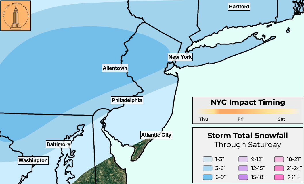
A moderate impact winter storm appears increasingly likely for the NYC Metro Area. Confidence is currently highest in 3-6″ of snowfall across the entire region from Thursday into Friday. Higher amounts are also possible, and are forecast over Eastern Pennsylvania and Northern New Jersey at this time. It is distinctly possible that these amounts will be moved to include the NYC Metro Area in future forecast shifts.
As a reminder, the National Weather Service has issued a Winter Storm Watch for the NYC Metro Area from Thursday through Friday. This means that a winter storm is increasingly possible during this time frame.
We’ll have further updates on the storm system and anticipated impact through Wednesday as the latest data becomes available.
baran aydin
baran aydin
türk kahvesinin faydaları
bakkal acmak karlı mı
Very interesting details you have observed , thankyou for putting up. “These days an income is something you can’t live without–or within.” by Tom Wilson.
hurdacı firmalar içinde lideriz. En yakın istanbul hurdacı telefonu olan numaramızdan ulaşabilirsiniz