-2")
Tropical Storm Elsa Impacts for the NYC Metro Area
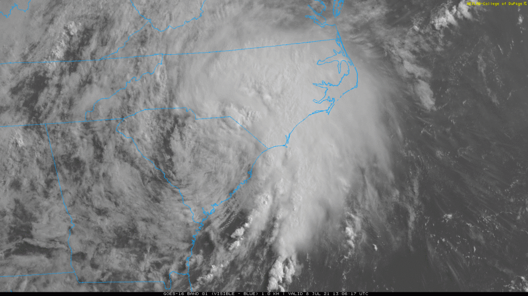
A frontal boundary and upper-level trough northwest of the area will begin to interact with Tropical Storm Elsa tracking northeast up the coast today. Scattered showers and thunderstorms will begin to develop around the region this afternoon and early this evening, with a muggy, unstable airmass in place. These storms could become strong or severe and capable of producing isolated damaging wind gusts or tornadoes, especially with stronger shear and forcing over the Interior areas.
Then the right-rear quadrant of an upper-level jet streak will begin to move closer and enhance forcing over more of the region. This will cause more widespread showers and thunderstorms to develop ahead of Tropical Storm Elsa later this evening. This process is also known as a Predecessor Rain Event, which occurs well in advance of a tropical system reaching the area. These showers and thunderstorms this afternoon through early tonight could contain torrential downpours and result in localized flash flooding.
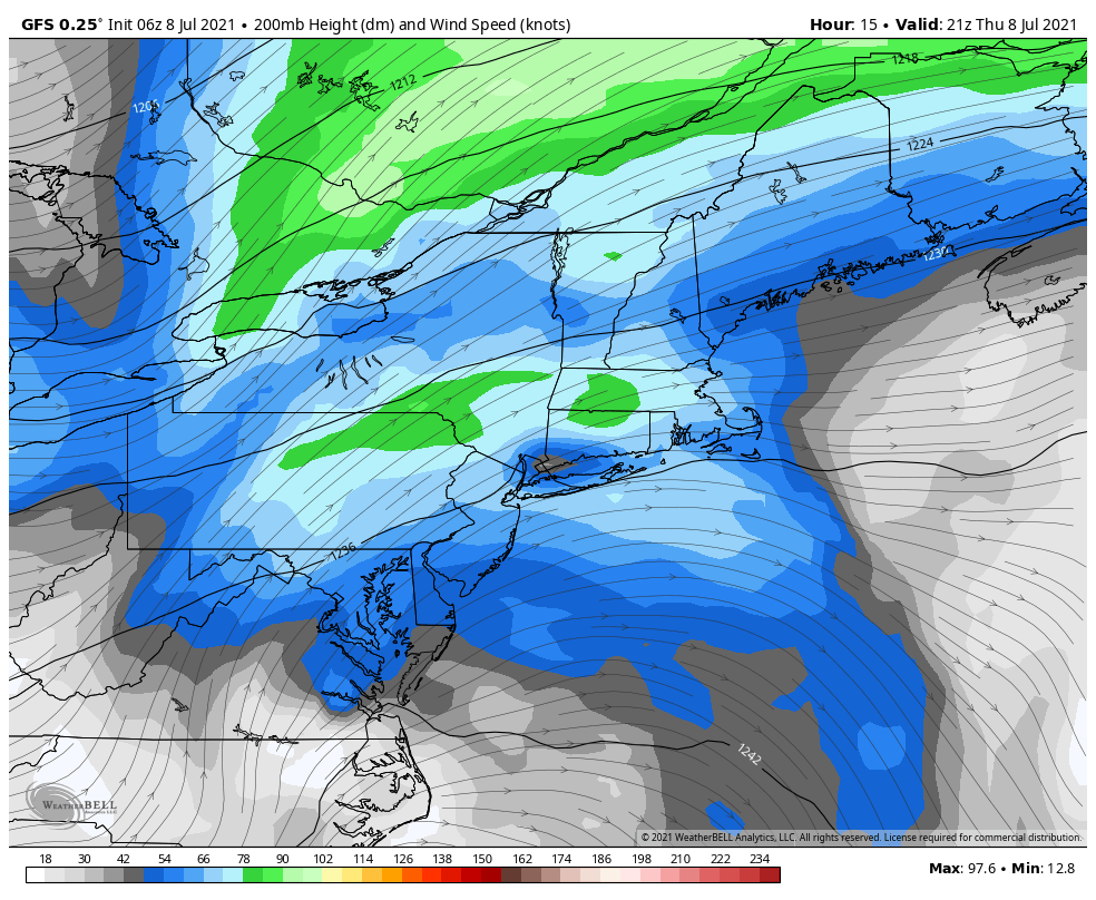
Tropical Storm Elsa is currently a minimal tropical storm with maximum sustained winds at 45 mph and is moving northeast at 20mph. Elsa could intensify more as a tropical storm tonight and tomorrow as it begins to phase with the upper-level jet streak. The exact track of Elsa will determine the amount of the impacts on the area. Tropical systems undergo baroclinic enhancement (phasing) the Mid-Atlantic and Northeast US, have the heaviest rains on the west side of the track and strongest winds on the east side.
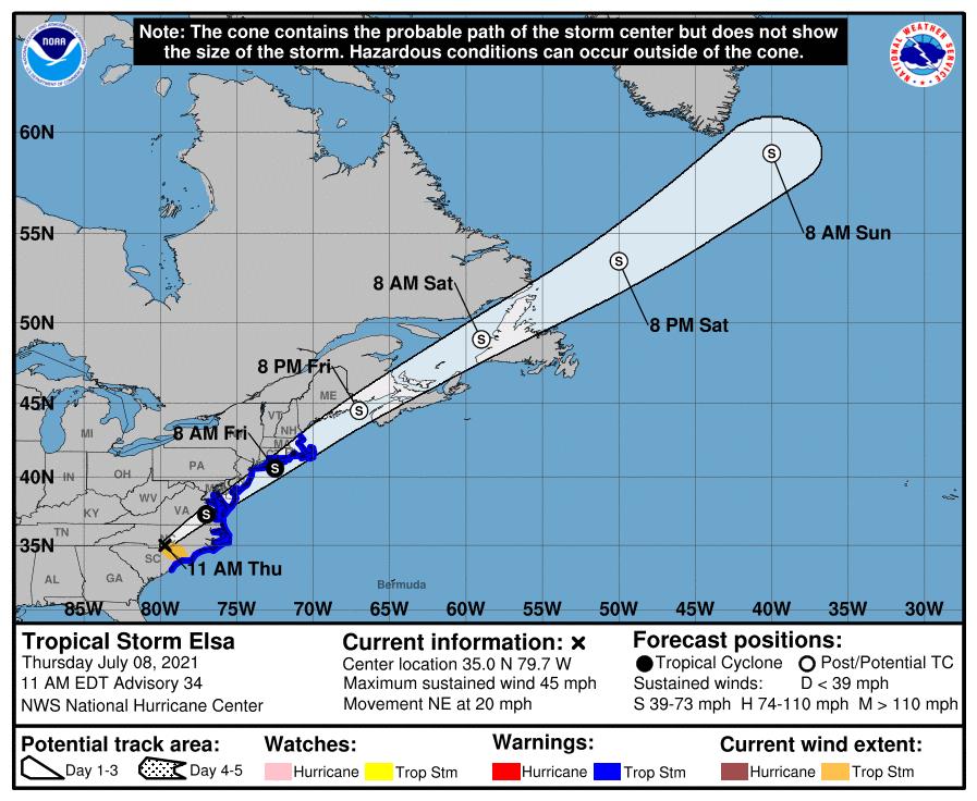
The National Hurricane Center forecast and watches and warnings for Elsa

Based on the latest forecast track from the National Hurricane Center, which takes Elsa over Southeast New Jersey and Eastern Long Island, heavy rainfall and flash flooding will biggest threat for New York City metro and inland areas of New Jersey and Connecticut. A period of steadier, heavier rain with some gusty winds is likely very late tonight or Friday morning. Widespread rainfall totals between 2 to 4 inches and locally higher totals are likely by Friday afternoon. Flash flooding could occur on roadways and make for hazardous driving conditions. Never drive through flood waters!
The strongest winds from Elsa are most likely to occur late tonight and Friday morning over Long Island and coastal sections of New Jersey and Connecticut, where the Tropical Storm Warnings have been issued. Sustained winds could be between 40-50mph with gusts up to near 60mph for at least a few hours, as Elsa’s center passes nearby. These winds could cause tree damage and power outages. Around New York City, winds are likely to be between 20-30mph with some gusts to up to near 40mph possible.
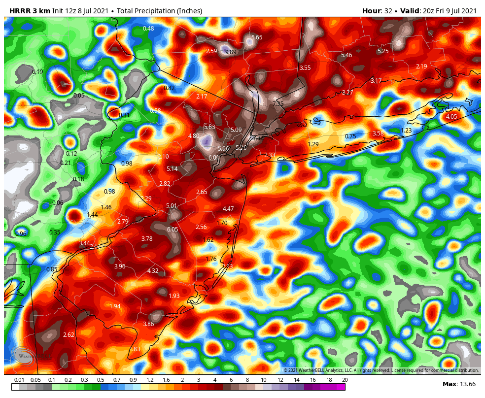
The HRRR models shows rainfall totals widespread 2″-4″ and locally up 6″ in the region
Tropical Storm Elsa will be tracking quickly through the region. So we don’t anticipate any significant storm surge or coastal flooding in the region. There is also a low risk for Elsa’s outer rain bands to produce a few isolated tornadoes or waterspouts, especially along coastal sections later tonight into Friday morning.
We will continue to monitor the latest developments with Elsa’s remnants until they depart the area quickly late Friday morning. Some scattered showers and thunderstorms may redevelop in the area Friday afternoon and evening with frontal boundary still nearby.
Overall, we aren’t expecting severe impacts from Elsa. But any changes in the current forecast track could result in heavier rains impacting coastal sections more or stronger winds further inland. Check back this briefing or on our social media accounts for more updates.
baran aydin
baran aydin
türk kahvesinin faydaları
Good – I should definitely pronounce, impressed with your web site. I had no trouble navigating through all tabs as well as related info ended up being truly easy to do to access. I recently found what I hoped for before you know it in the least. Quite unusual. Is likely to appreciate it for those who add forums or anything, website theme . a tones way for your customer to communicate. Nice task.