-2")
Strong coastal storm to impact NYC starting tonight
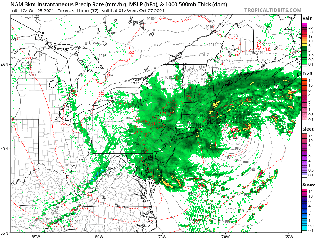
A strong low pressure system will develop off the Mid-Atlantic coast from tonight into Tuesday morning. Periods of heavy rain and flooding are likely in the NYC Metro, with rainfall totals of 2-4″ expected. Travel delays and difficulties are likely. While a notable storm will occur, we do not expect the impacts from this system to be similar to those experienced from Tropical Storm Ida in September.
Although we will be dry for the rest of the daytime hours today, conditions will deteriorate as the night progresses, with much of the area likely seeing multiple periods of heavy rain and flash flooding. While there are still a few tricky intricacies to the forecast, confidence is increasing that the majority of the area will see over 2″ of rain — with localized rainfall totals over 5″ — from tonight through Tuesday evening. This article will detail what we can expect in terms of timing and impacts during each phase of this storm.
8pm Monday through Midnight Tuesday Morning:
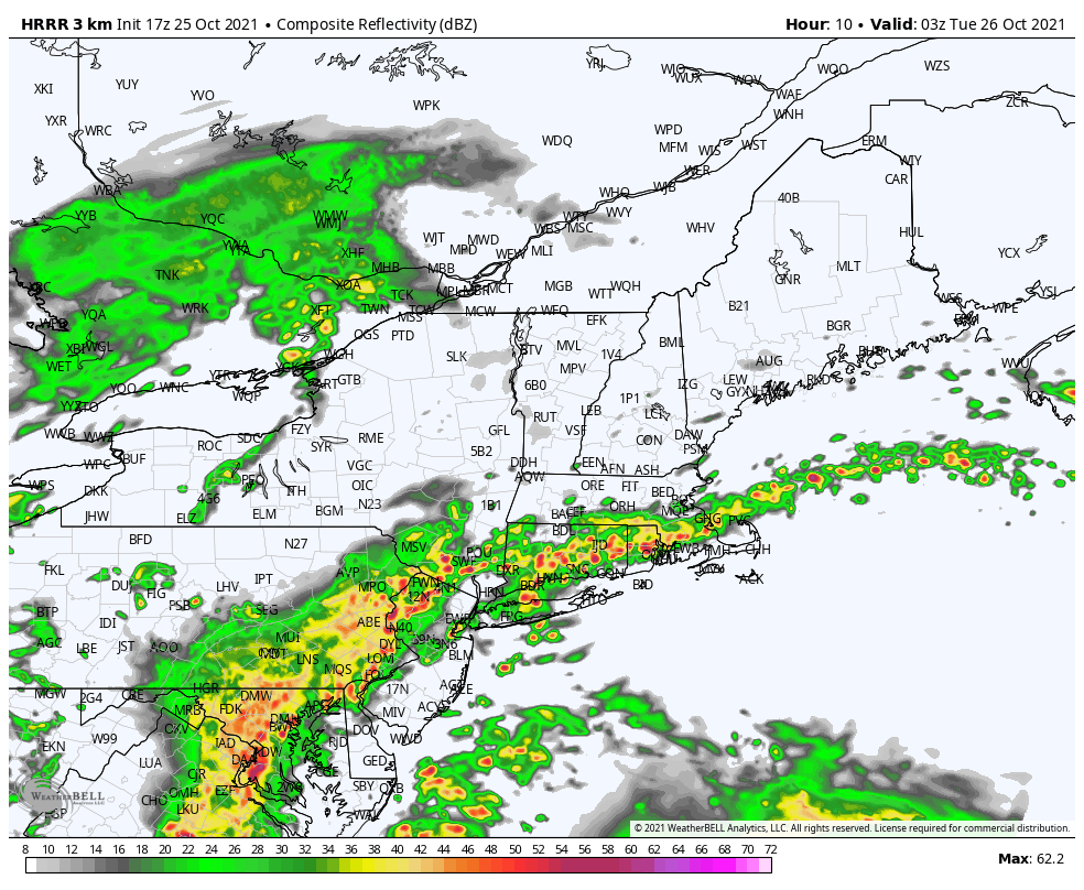
A strong warm front will interact with both a dynamic trough to our west and an offshore low pressure, leading to periodic showers and embedded periods of heavy rain. The main coastal storm system will not be consolidated yet, which means that this window could see the heavier rain focus in western areas, such as Eastern PA and Western NJ. 1″+ per hour rainfall totals will be possible. Much of NJ into NYC, Long Island, and CT will see hit-or-miss rain showers and a burst or two of rain, but not necessarily consistent heavy rain just yet. Isolated strong thunderstorms with gusty winds will also be possible.
Midnight through 6am Tuesday Morning:
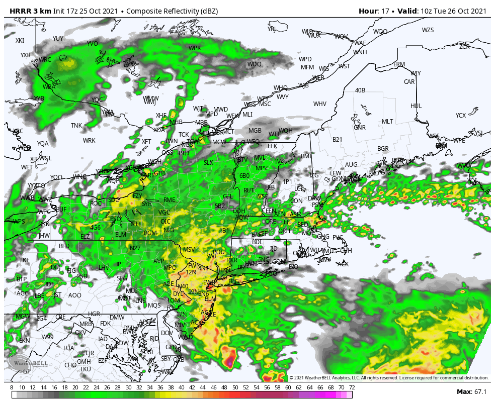
Offshore low pressure will gradually become more dominant as this system strengthens and energy from the trough to our west “transfers” to it. This window is when lift in the atmosphere will peak, thus allowing for the highest rainfall rates during this entire storm. Heavy rain will slowly expand and shift east into NJ, SE NJ, NYC, and Western Long Island — and intensify — as the overnight progresses. Heavy rain and flash flooding are expected, and parts of NJ may see 3-6″ of rain in just this window alone. Eastern PA may only be on the edge of heavy rain in this window. Locally strong thunderstorms with gusty winds will continue to be possible as well.
Come 6am Tuesday morning, much of the entire NYC Metro will still be experiencing heavy rain. The forecast after 6am Tuesday becomes tricky.
6am Tuesday through 6pm Tuesday
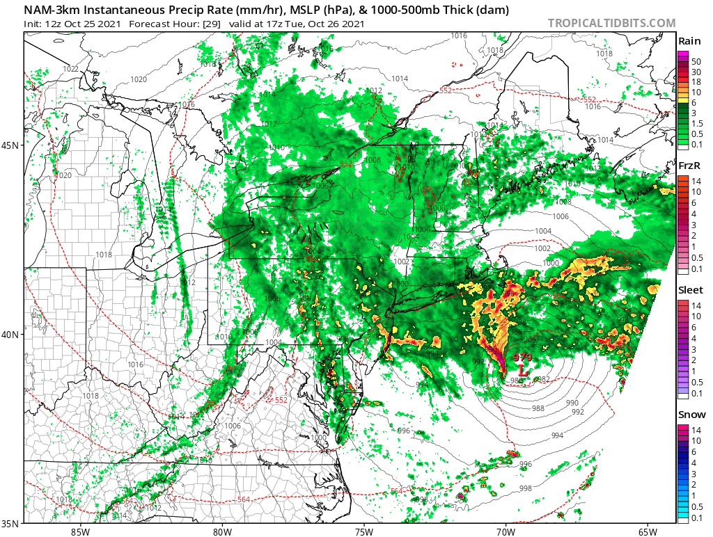
The midnight-6am Tuesday window involves the transfer of energy toward the coast, which allows for the highest ceiling of rainfall rates. But after 6am, when the coastal low becomes more dominant, it is unclear what will happen to the orientation of precipitation. Periods of heavy rain may continue to get pulled from that system north and west into the area throughout Tuesday morning — especially for Long Island — with flash flooding still being possible.
But once the coastal low pressure truly takes over, it is possible that precipitation consolidates towards that low pressure center, away from our area. Furthermore, the warm front responsible for “fuel” and moisture during the overnight will weaken as the day goes on. This means that at some point during the day on Tuesday, rainfall rates will become lighter and more sporadic across much of the area, while heaviest rain shifts towards Southeast New England. Exactly when that occurs will determine how much rain we see on Tuesday.
Regardless, periods of rain will continue throughout much of the day. Steady rain, along with lulls in the action are both expected. Downpours are still possible, but rainfall rates will not be as high as they were during the overnight. We are not expecting any strong thunderstorms during the day, either.
While it will be breezy at times, with 30mph+ gusts likely on Long Island and 40mph+ gusts on Eastern Long Island, the main coastal low pressure system will consolidate too far east for a widespread significant wind event with this system.
6pm Tuesday through 6am Wednesday:
During this window, the coastal low pressure will have consolidated well to our east, removing any heavy rain threat. But periodic rain showers will continue to get pulled from that system into much of our area. Rainfall rates will generally be light, with occasional moderate bursts. As time goes on, rainfall coverage will gradually decrease, with much of the overnight hours being mainly dry. We should be completely dry by Wednesday morning.
Rainfall totals:
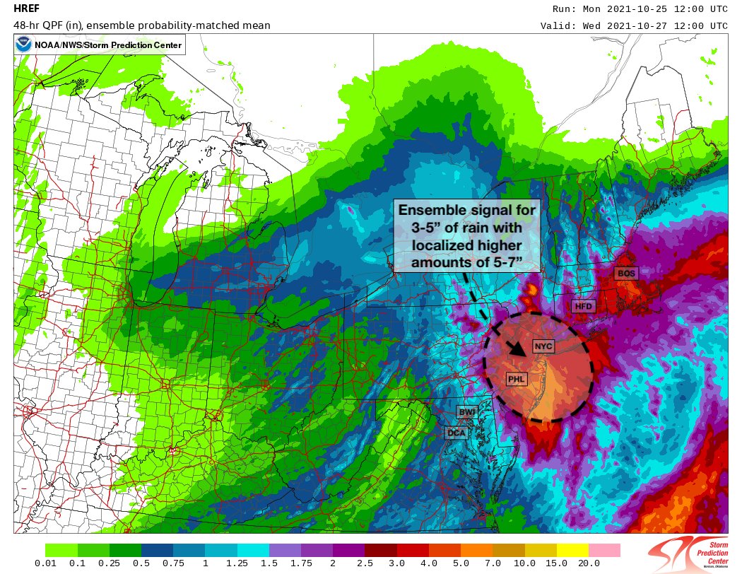
While the exact location of the heaviest rain is uncertain, especially given the uncertainties regarding the transfer toward a consolidating coastal low pressure system and the duration of heavy rain on Tuesday morning, we are still expecting significant rain for much of the area. Almost the entire NYC Metro area will likely see 2-4″ of rain, and localized areas — especially in New Jersey — are expected to see 5-7″ of rain. Rainfall rates over 1″ per hour at times, especially late tonight into early Tuesday morning will lead to flash flooding, but fortunately the degree of flooding will not match what we saw during the remnants of Ida.
We will be posting social media updates frequently throughout this system. Stay safe!
Heya i’m for the first time here. I found this board and I find It really useful & it helped me out a lot. I hope to give something back and help others like you helped me.