-2")
Colder pattern increasingly likely to end November in NYC
For the past several days, the NYC Metro Area has been fortunate enough to bask in unseasonable autumn warmth. The proverbial clock is ticking, however, as we continue to march towards winter. We issued our 2021-2022 Winter forecast last week and called for an early start to winter, and recent extended weather model data has begun to align with our thoughts.
It’s only November 11th, how do we already know how winter will begin?
This is a valid question, as there is a limit to the accuracy of extended model data. Think about chaos theory – the further in advance a weather model is forecasting, the less accurate it will be. In short-term forecasts, such as tomorrow’s weather, we aim to forecast with a high degree of precision, such as exact high temperatures to the nearest degree and timing of precipitation down to the hour. Maintaining that precision at long lead times (such as three weeks in advance) is nearly impossible, and would prove to be inaccurate. Instead, we look for broad windows where we can expect above or below average temperatures; and at long lead times, these broad windows can be deciphered at least somewhat accurately.
What is the evidence we have for a cold start to winter?
Understanding how the jet stream may behave a week or two from now is not an easy thing to do. However, we can look at the evolution of the pattern across the entire hemisphere for hints as to how things might shake down.
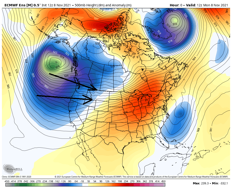
Above, we see the weather pattern which we’ve been experiencing over the past several days. A large trough south of Alaska and off the Pacific US coast allows air to move from west to east into the United States. With that in mind, this trough contributes to sending mild, Pacific air into the US rather than Arctic air from Northern Canada. When one combines this with a ridge in the Eastern US, we get a very mild weather pattern.
Over time, however, the orientation of the North American weather pattern will change.
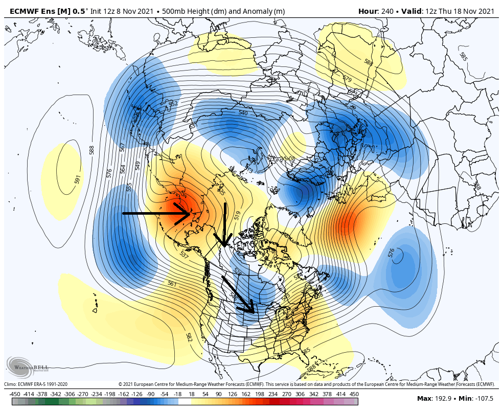
Note the forecast for ten days from now, showing almost the opposite weather pattern with the large trough off of the West Coast being replaced by a ridge. Of particular interest is the large ridge just west of Alaska bulging into the Arctic, resulting in the orientation of airflow being displaced from the Arctic southward into Canada. The ridge off the West Coast into the US allows that air to continue to travel from northwest to southeast from Canada into the US. Think of the airflow ahead of that ridge almost like you are going down a slide.
A ridge near Alaska bulging into the Arctic has been notorious for producing widespread cold across much of the US. Typically, for cold weather in the Eastern US specifically, we look for one or two tweaks to the weather pattern shown above: 1) the ridge west of Alaska to shift east, into Alaska itself, to give the cold air an inherently eastward “head start” and/or 2) a ridge to develop near Greenland to force a trough to get “blocked” to its south.
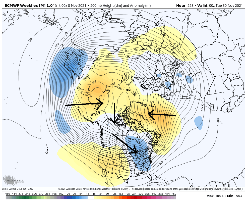
Rolling forward a couple of more weeks brings us to the European Weekly forecast valid for November 30th. Notice how this pattern directly aims cold air towards the Eastern US from the Arctic as a result of ridging near Greenland. This pattern is historically conducive for colder than normal temperatures in the NYC Metro and Northeast states.
If this were to occur, a cold and likely snowy pattern could occur to close November and begin December in our area. However, the formation of a ridge near Greenland is certainly not a guarantee; and on its own, the initial ridge being west of Alaska rather than in Alaska itself favors consistent cold in the Central US with only transient cold and rainstorms in the Eastern US.
Summary: Colder than normal weather is increasingly likely in the NYC Metro Area beginning next week and continuing into the end of November – perhaps early December as well. It is possible that this cold pattern could allow for early-season snowstorms, but that piece of the forecast puzzle remains highly uncertain for now.
baran aydin
baran aydin
türk kahvesinin faydaları
I have been browsing online more than 3 hours today, yet I never found any interesting article like yours. It’s pretty worth enough for me. In my opinion, if all website owners and bloggers made good content as you did, the net will be much more useful than ever before.