-2")
NYC Forecast: Transitional Week, Colder Than Normal Pattern Looms
Transitional weather is expected this week, with a gradual warmup culminating in a cold frontal passage on Friday. Much colder air will move in behind the front, with all ensemble guidance indicating that a colder than normal (and stormy) pattern will settle in beginning next week.
The week began with chilly but relatively quiet weather. We’ll see temperatures warm up a few degrees today, but a blustery northwest wind will keep high temperatures in the lower 50’s. Overnight lows will remain quite cold. In fact, the NWS has issued a Frost Advisory for the NYC Metro tonight into Wednesday morning.
Parts of the NYC Metro proper (including Manhattan, Brooklyn and Queens) have not technically seen a hard freeze so far this fall. The NWS issues these frost and freeze products up until the first hard freeze of the season occurs, effectively ending the growing season.
Temperatures will warm up as we move into the middle and latter half of the week. By Thursday, high temperatures will be several degrees above normal again, likely reaching at least the lower to middle 60’s. We’ll have southerly winds to thank for that, strengthening ahead of an approaching cold front.
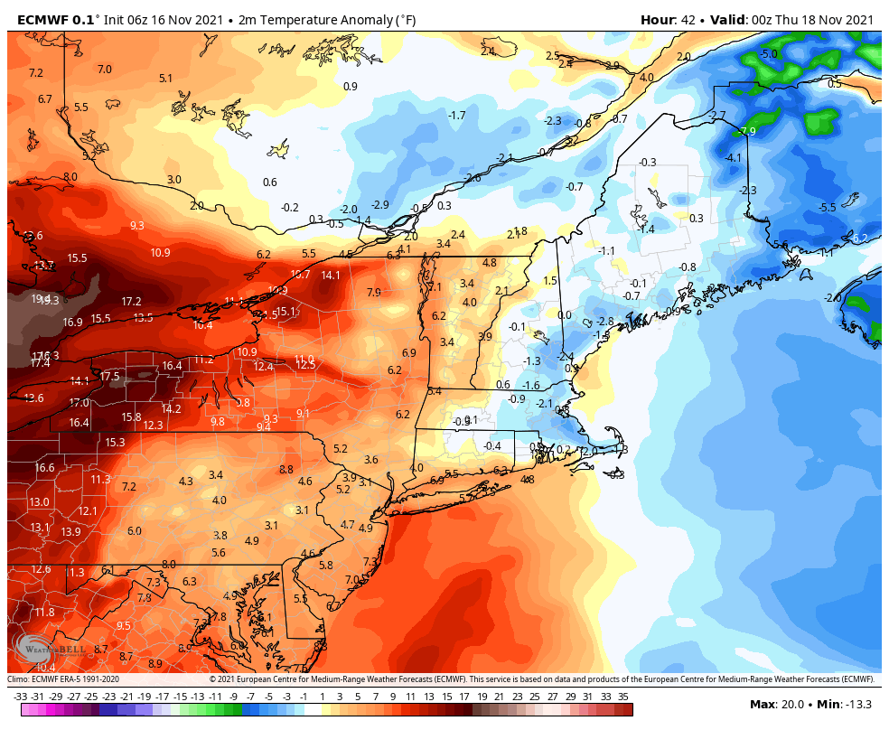
The cold front will approach the area Thursday evening, with showers and perhaps a few embedded rumbles of thunder anticipated. Rainfall totals are not expected to be hazardous and any flooding will be localized. The front will move through the area by the morning commute on Friday, with blustery west/northwest winds ushering in much colder air.
High temperatures on Friday and Saturday are not expected to get out of the upper 40’s. It will be a chilly weekend, with the blustery winds continuing and a fresh Canadian airmass overhead. This will be just the first shot of cold air in a sequence – with all model guidance suggesting that a colder than normal pattern will settle in to the area by next week.
Substantial storm possible in the Northeast US next week
In addition to rising confidence in a colder than normal pattern, ensemble guidance continues to strongly hint at the development of a notable storm system in the Northeast US next week. One of the main culprits for the colder than normal pattern is the development of high latitude blocking, or ridges of high pressure in the higher latitudes of the Arctic. These often displace cold air southward from the Arctic into Canada and the United States.
In addition, these high latitude blocks can act as roadblocks on the atmospheric “highway” that can cause traffic jams and accidents. In other words, they slow things down so much that storm systems tend to grow stronger, merge and interact with other storms, and cause unusually active conditions.
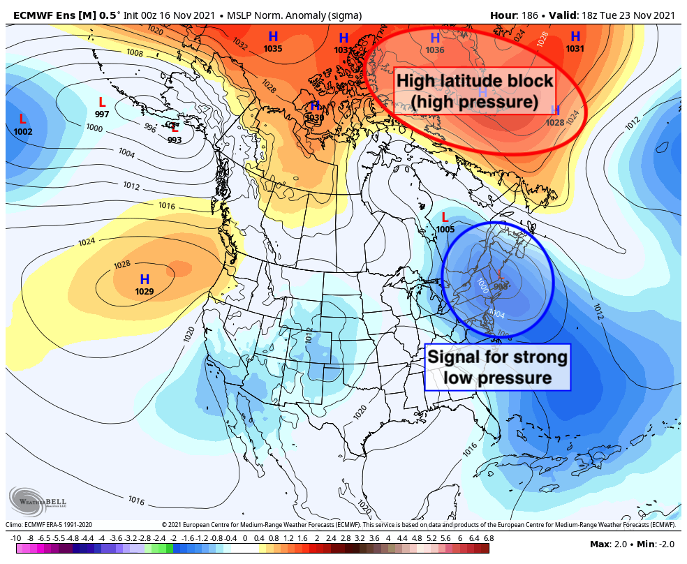
The first stages of high latitude blocking are already underway near Alaska, but we’ll see blocking developing in Greenland and parts of Canada by next week. The first in a series of storm threats will likely evolve across New England as a result. Model guidance is hinting at the possibility of unusually low pressures and strong disturbance over New England around 6 days from now.
We’ll have to keep a close eye on the potential development of this storm system, as it could bring hazardous weather to parts of our area. As always, at this lead time any potential impacts or details are highly uncertain. We’ll be keeping a close eye on this period moving forward.
As for winter weather, this system will likely be the first in a series of events that could bring wintry weather to the Northeast states. We’ll have a detailed technical breakdown on what this means for winter weather potential in the NYC Metro Area from late November into early December. Stay tuned…
I’ve recently started a website, the info you provide on this website has helped me tremendously. Thank you for all of your time & work. “A creative man is motivated by the desire to achieve, not by the desire to beat others.” by Ayn Rand.
OMG, Sprunki Phase 7: Ongoing Onslaught is an absolute banger! The music tracks slap so hard, and the visuals are next-level. This dev team never misses!
The vibes in Sprunki Phase 8: Battered and Bleak (Uc’s Take) are immaculate! The music is an absolute banger, and the gameplay feels so smooth. Can’t wait to see more from this creator!
NGL, Sprunki Phase 4.5 Definitive (My Take) is low-key sus in the best way possible. The glitch effects are so well-done and they don’t break the game. Total masterpiece!