-2")
NYC Forecast: Showers Thursday, Dry and Cool Weekend
Warm temperatures are expected on Thursday, but showers will move back into the area by the afternoon. Improving weather is expected thereafter, with dry and cool conditions persisting through the upcoming weekend. Another storm system may impact the area on Monday.
Temperatures over the past few days have averaged a few degrees below normal in the NYC Area, the tale of the tape for much of the month of November. Other than some #moodflakes, it has also been quite dry over the past few weeks. The pattern will gradually become more active as we move through the next week or two.
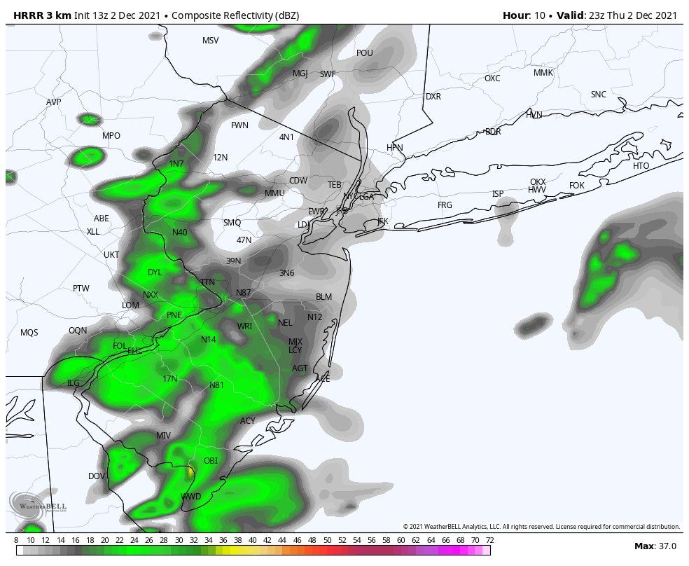
Unsettled weather is expected later today (Thursday). After showers this morning, temperatures have warmed and will continue to warm quite a bit above normal – into the middle to upper 50’s. The second round of showers will approach the area this afternoon, and a cold front will sweep past the area tonight.
Cooler weather is expected behind the front this weekend with a northerly wind component returning. High temperatures on Friday, Saturday and Sunday will again struggle out of the mid 40’s. The good news is that conditions look mostly pleasant and dry with plenty of sunshine.
The next storm system of significance will approach the area early next week. Model guidance suggests that clouds will increase late Sunday and showers could enter the region by late Sunday night. Periods of rain are possible on Monday as a strong low pressure system moves into Southeast Canada.
Behind the storm system early next week, cooler weather is again expected to return. Temperatures should average a few degrees below normal over the next several days.
Pattern change will lead to warming temperatures by mid December
A colder than normal pattern has dominated the area’s weather for the last few weeks, but the winds of change are blowing. Sorry, we had to do it. Ensemble data suggests that the mid and upper level height pattern across the hemisphere will become conducive to warmer than normal temperatures across basically the entire country by mid December.
The polar vortex is expected to tighten up considerably and return back to the Arctic regions while the pattern in the Pacific becomes agitated and the Pacific jet stream extends eastward. This will allow mild, Pacific air to flow into the United States unabated.
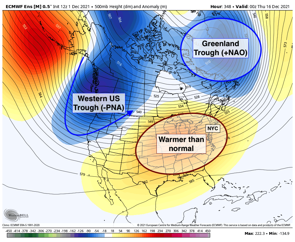
What does this mean for us in terms of sensible weather? Quite simply, expect temperatures to gradually warm as we move towards mid December. Notably, winter weather threats should be off the table in the NYC Metro for the foreseeable future. There are some hints that a colder and active pattern could return by late December, but confidence is quite low in any sensible impacts on a forecast more than three weeks in advance.
For now, settle in and enjoy a drier than normal pattern. While there will be some transient storm systems, widespread precipitation or hazardous weather events seem unlikely, and temperatures will trend gradually warmer over the next few weeks. Ol’ man winter is still asleep for now.
I think this is among the most significant info for me. And i’m glad reading your article. But want to remark on some general things, The website style is perfect, the articles is really great : D. Good job, cheers