-2")
Snow likely in the NYC Metro on Friday, details still unclear
Icy conditions are finally letting up in the city this morning, but continue north and west of town. Light freezing rain is expected to persist for another hour or two before changing over to plain rain in all areas. The NWS issued a Winter Weather Advisory for the NYC Metro and surrounding areas, and that continues for the next few hours. Conditions should start to improve by early this afternoon.
Behind this storm system, a frontal boundary will drop south of the NYC Metro. This will allow for temporarily improving conditions on Thursday. To our southwest though, a stronger disturbance will be organizing in the Tennessee Valley. That low pressure will eventually be responsible for winter weather in our area on Friday.
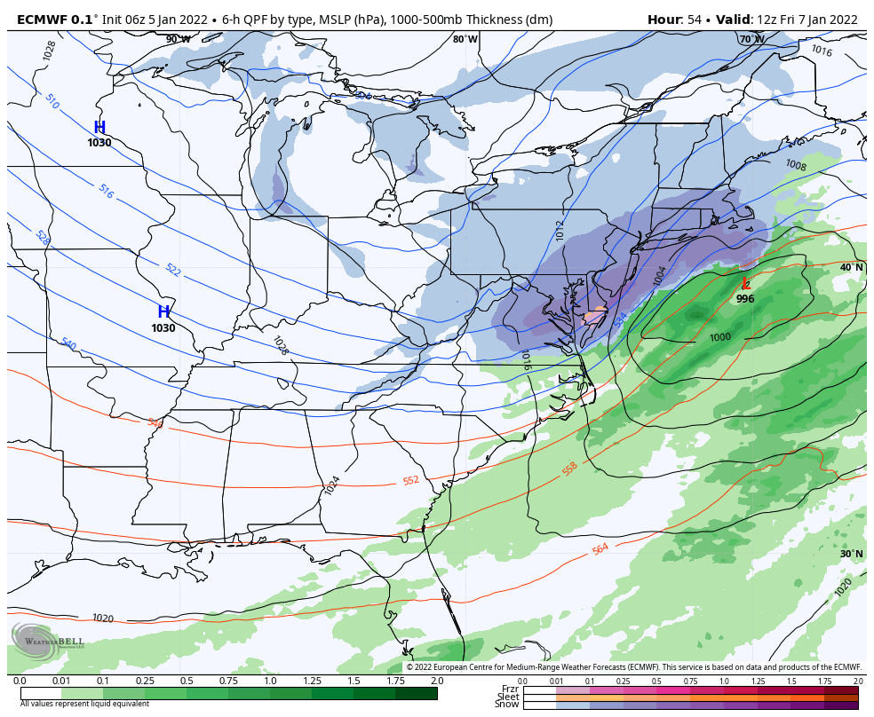
A disturbance in the mid levels of the atmosphere will emerge from the Tennessee Valley towards the Mid Atlantic states late Thursday. From there, that disturbance is expected to amplify northward, with a low pressure forming off the East Coast. It is that amplification which is an inflection point in the forecast – just how much the storm amplifies will determine how impactful it will be for us.
Forecast models are still showing a significant amount of spread and uncertainty with the track of the storm. Weather forecasters often use ensembles to help visualize and understand the sensitivity in the forecast and the envelope of possible solutions. The Euro model has 51 ensemble members, each of them a bit different. In this case, the spread in possible track between those 51 members is still between 300-400 miles from west to east. That’s a huge range!
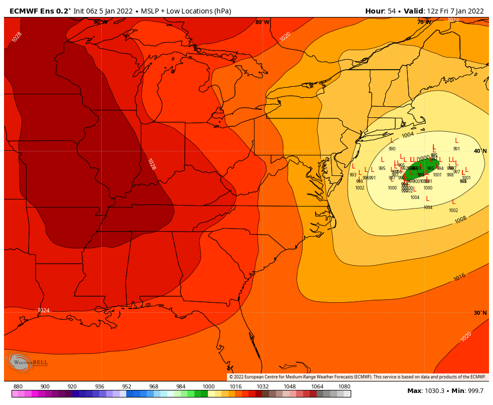
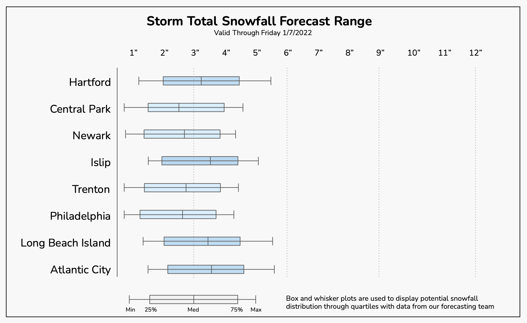
Regardless, confidence in some impacts has increased. It now looks likely that NYC will see at least light accumulating snow on Friday. The uncertainty lies in the potential for something more. That will depend on how much the storm can amplify and strengthen. The more it does so, the stronger its bands of snow will be, and the higher the ceiling will go for snowfall totals.
Recent model guidance has started to trend more amplified with the storm, allowing it to strengthen faster and produce stronger precipitation. If those trends continue today, we could see an uptick in forecast snowfall amounts.
Timing, details and expected impacts
The storm system is expected to be a quick hitter – in and out in just several hours. Here’s the current anticipated timing and hazardous weather impacts. In the NYC Metro, this is currently expected to be a light impact winter storm, but if the storm trends stronger it could reach into moderate impact territory.
6pm – 9pm Thursday: Light snow begins to break out in Eastern PA and Western NJ. This snow will gradually increase in intensity and produce light accumulations, but conditions could become slick during this time. No snow is expected in NYC yet.
9pm Thu – 12am Fri: Light snow will overspread New Jersey and the NYC Metro. Snow will gradually increase in intensity. Heavier snow is expected during this time over Southeast PA and Southern NJ.
12am – 3am Fri: Snow is likely across all of New Jersey and the NYC Metro during this time. Depending on how strong the storm gets, it could be heavy during this time. If not, it will at least be light. Accumulations are likely on all surfaces.
3am – 6am Fri: Snow will begin to wrap up from west to east and winds could become blustery for a few hours. Lingering snow is expected across CT and Long Island during the time. Again, if the storm is stronger, it could be heavy in those regions.
6am – 9am Fri: Clearing is expected in all areas during this time frame with blustery winds and improving conditions overall.
Stay tuned for further updates over the next 12-24 hours as the forecast comes into better view and confidence increases in impacts. We will continue to update our snowfall forecast ranges as we get closer to the storm. If you’re planning to travel from Thursday PM into Friday, have a backup plan or check with your travel carrier as we get closer to confirm any delays or cancellations.
Merely wanna remark that you have a very nice web site , I enjoy the layout it really stands out.
Adrese gelen istanbul hurdacı firması olarak hizmet veriyoruz.
Great content! Keep up the good work!