-2")

Strong coastal storm possible this weekend as wintry pattern takes control
A wintry switch was flipped on the weather pattern last week, producing snow and cold in the NYC Metro Area over the last several days, and more may be on the way. The pattern ahead looks primed to deliver cold and additional chances for snow. Forecasters are honing in on the potential for another substantial coastal storm this Sunday and Monday.
Forecast model guidance shows the possibility that a strong coastal storm could develop this weekend, originating in the Southeast states and developing up the East Coast. Early indications are that the storm could be quite strong. The main question is how far north and west the storm will track, and the resulting impacts that will occur in our area.
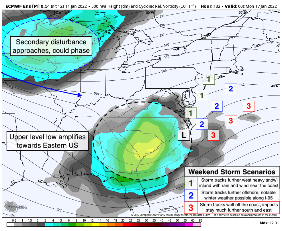
Similar to the last winter storm, there is a trifurcation developing among computer models as the storm moves northward. A storm tracking far inland and strengthening rapidly would bring the potential for heavy rain and coastal flooding. A storm tracking near but off the coast could bring a significant winter weather event. And finally, a storm tracking several hundred miles offshore would bring limited impacts. All three scenarios are still very much on the table.
The storm is developing as a result of a strong mid and upper level disturbance that is forecast to move from the Northern Plains into the Southeast states. Once it reaches the Southeast, computer models suggest it will turn, amplify, and begin to head up the East Coast. This alone could present the possibility of impactful weather in our region.
The additional zest with this system will be a second disturbance surging southeastward from Canada. Some computer models suggest that this could “phase” or merge with the original disturbance near the coast, acting like a spark to an already anomalous pattern and resulting in an even stronger storm system.
As you might imagine, computer models are having a hard time with this one. This is a complex weather pattern, and so we expect to see varying solutions and ideas on guidance in the next few days. It won’t be until Thursday or so that we will begin to gain some confidence in how the storm might impact the NYC Metro.
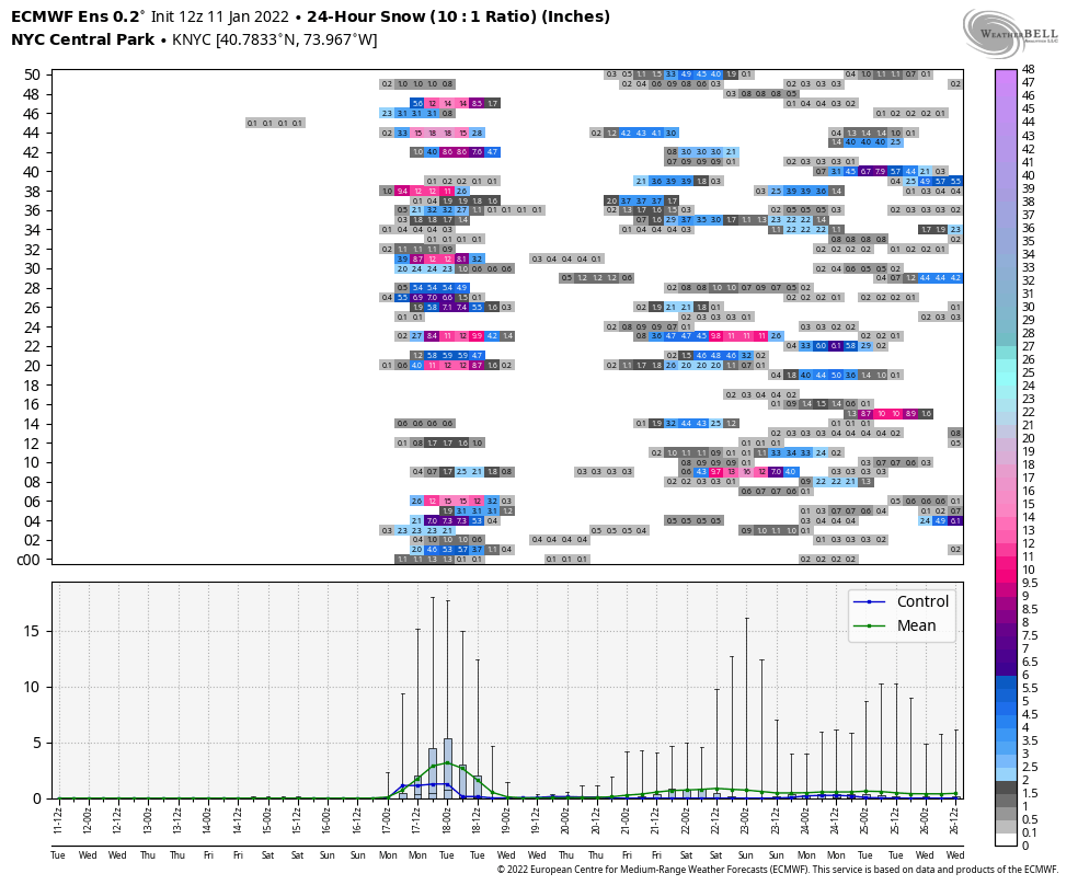
For now, we’ll keep a close eye on computer models and ensemble data and try to narrow down the envelope of possibilities. Confidence is growing that our area will be impacted by this storm, and we’ll be working hard to try to get to the details of exactly how we will be impacted in the coming days.
A colder and active pattern continues after this weekend
Beyond the storm system which may impact our area this weekend, the weather pattern looks very likely to remain colder than normal and quite active. Computer models are in good agreement that a large ridge will develop in Western North America, while poking northward into the Arctic regions.
This will help to dislodge cold, Arctic air that is typically bottled up to the north of Alaska and send it southward into Canada and the United States. Our area will remain directly in the firing line of these arctic air masses in the next 10 to 14 days.
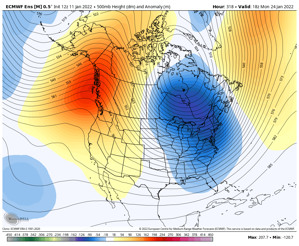
Meanwhile, multiple disturbances are also expected to traverse the country during this time. With anomalous cold air in place, one or more of these disturbances is likely to produce a threat for wintry weather in our area. While the storm this weekend is a focus, it appears that we will be busy for a while even after it is gone.
Strap in and get comfortable. Winter has arrived.
I’ll immediately grasp your rss as I can not in finding your email subscription hyperlink or e-newsletter service. Do you’ve any? Please allow me realize so that I may subscribe. Thanks.