-2")

Snow quickly transitions to rain with blustery winds in NYC tonight
Another strong coastal storm is forecast to develop tonight. Despite the bitter cold which settled in to the area over the past 24 hours, this storm will be characterized by warm air. Snow is expected to quickly transition to sleet and rain in the city, with periods of heavy rain through tonight. Minimal accumulations are expected, but gusty winds and coastal flooding are likely.
As we speak this afternoon, the second coastal storm in about a weeks time is getting itself organized over the Southeast states. Bitter cold temperatures were observed overnight last night and into this morning, with Newark dropping into the single digits for the first time since 2019.
Despite the cold which has been in place, the storm approaching our area tonight will be a dissapointing one for winter weather lovers. It’s loaded with warm and moist air, and it’s bringing all of it northward, significantly limiting the opportunity for snow accumulations near the coast and in the NYC Metro.
Snow is expected to begin tonight, likely between 5 and 6pm in New Jersey and the NYC Metro. A few hours of snow is likely, with light accumulations especially in the interior. Quickly, warm air will begin working into the area. Coastal New Jersey, Long Island, and the NYC Metro will be the first to change over. Gradually, this transition line with work northward into Northern NJ and Southeast NY as well.
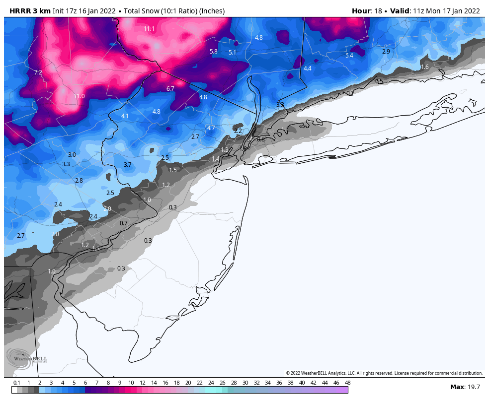
Before the first raindrops fall, a light snowfall accumulation is expected in the metro. Our current forecast calls for a Trace to 2″ in Central Park and Newark, with less than 1″ in Brooklyn and Staten Island. The northwest suburbs will fare better – we expect 2-4″ of snow in Morristown and White Plains before rain works its way into those areas as well.
Once the transition to rain occurs, precipitation intensity will markedly increase. We expect a few hours of heavy rain overnight tonight. Strong east/southeast winds will bring an onshore flow and blustery winds to the entire region. This will be especially probelmatic for parts of the NJ Shore and Southern Long Island, where coastal flooding is distinctly possible. Even in the NYC Metro, some coastal flooding is possible and winds may gust as high as 50mph.
The storm is expected to begin to pull away from the NYC Metro by around daybreak on Monday. As cold air rapidly surges back into the region, a few snow showers are possible from Monday morning into Monday afternoon. We aren’t expecting any accumulation from these, but the temperature drop could lead to some slick spots on area roadways.
Conditions are expected to improve as we move into the midweek period, with cold but pleasant weather conditions through at least Wednesday. A few rain and snow showers are possible on Wednesday night and Thursday morning, but this system will be weak and isn’t expect to bring many weather hazards to the area.
The next chance for a substantial storm system will come next weekend, as the active and cold weather pattern continues. It’s likely that the threat for winter storms will persist for at least a few more weeks. In a pattern as cold and active as this one, it’s only a matter of time before a more substantial winter storm impacts the area.
Trackbacks & Pingbacks
[…] New York Metro Weather reports the area will likely see a “strong coastal storm,” and specifies that “snow is expected to quickly transition to sleet and rain in the city, with periods of heavy rain through tonight. Minimal accumulations are expected, but gusty winds and coastal flooding are likely.” […]
[…] New York Metro Weather reports the area will likely see a “strong coastal storm,” and specifies that “snow is expected to quickly transition to sleet and rain in the city, with periods of heavy rain through tonight. Minimal accumulations are expected, but gusty winds and coastal flooding are likely.” […]
[…] New York Metro Weather reports the area will likely see a “strong coastal storm,” and specifies that “snow is expected to quickly transition to sleet and rain in the city, with periods of heavy rain through tonight. Minimal accumulations are expected, but gusty winds and coastal flooding are likely.” […]
[…] New York Metro Weather reports the area will likely see a “strong coastal storm,” and specifies that “snow is expected to quickly transition to sleet and rain in the city, with periods of heavy rain through tonight. Minimal accumulations are expected, but gusty winds and coastal flooding are likely.” […]
[…] New York Metro Weather reports the area will likely see a "strong coastal storm," and specifies that "snow is expected to quickly transition to sleet and rain in the city, with periods of heavy rain through tonight. Minimal accumulations are expected, but gusty winds and coastal flooding are likely." […]
Leave a Reply
Want to join the discussion?Feel free to contribute!