-2")
Winter Storm Expected Saturday, NYC on Fringe of Heavy Snow
A strong coastal storm will develop on Friday evening, growing stronger through Saturday. The NYC Metro Area is likely to be right on the fringe of heavy snowfall, with a sharp gradient between little snow at all and significant snowfall totals. Forecast models continue to waffle back and forth with the storms exact track, which is leading to much more uncertainty than usual.
Meteorologists have been tracking the potential for a significant coastal storm this weekend for several days. The storm is forming as a result of two disturbances phasing over the Mississippi Valley. The first disturbance is currently over the Four Corners of the southwest states. The second is surging southward from Canada, and is eventually expected to pass through the Great Lakes and into the Mississippi valley on Friday.
The phase of these two disturbances will lead to very impressive jet dynamics, and a favorable environment for a rapidly deepening coastal storm. However, the phasing of two disturbances is a very fickle and highly intricate process. As a result, forecast models as struggling to pin down the track and intensity of the storm.
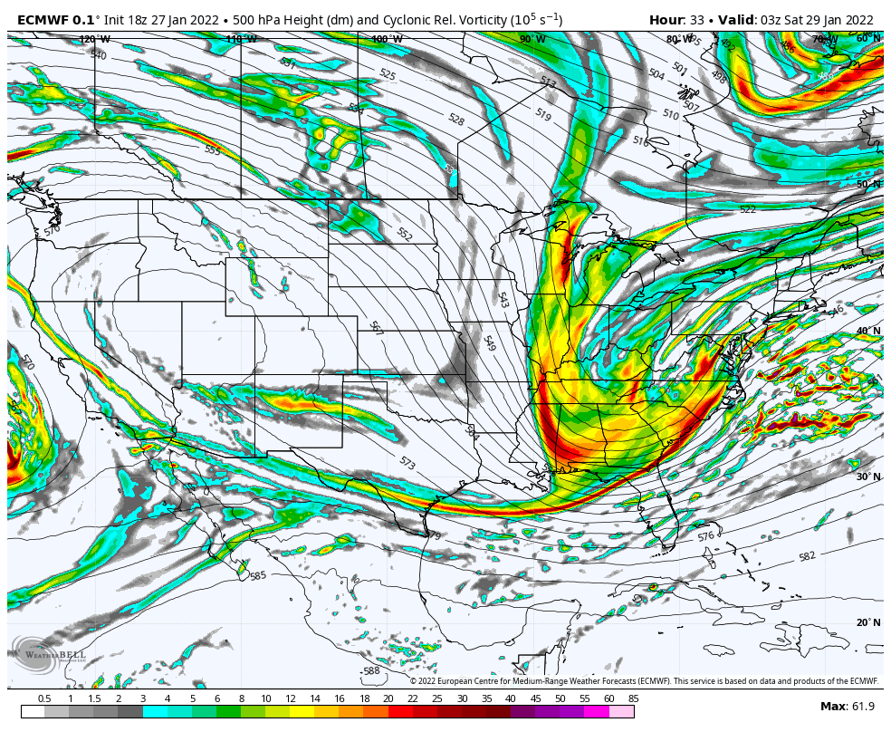
Much of the uncertainty comes from the timing and intensity of the phase itself. Exactly where the two disturbances phase, and how well they do so, will determine when the low pressure begins to strengthen. A faster, more efficient phase will pull the storm closer to the coast. A slower, sloppier phase will allow the storm to track further east.
Naturally, the NYC Metro lies right on the gradient of potentially significant snowfall. A slight shift to the east would leave the city in the lighter snowfall amounts, while a slight shift to the west would introduce the possibility of significant snow. What a great time to be a meteorologist!
Over the past 12-24 hours, forecast models have gradually begun to shift westward with the storms track. This makes the forecast even more complicated, as heavier snowfall totals are now re-introduced on Long Island. It won’t take much of a westward shift to bring heavier totals into NYC, either.
With that being said, given the spread and variance among model guidance, we are most confident taking a forecast that favors a blend – factoring in both the westernmost and easternmost outliers.
Timing and Impacts
Snow should begin by Friday afternoon – as a frontal boundary draws near the area. This snow won’t be associated with the main storm system, but develops along a weak frontal boundary near the area. Light accumulations are possible, especially on colder surfaces. This should continue into the early evening.
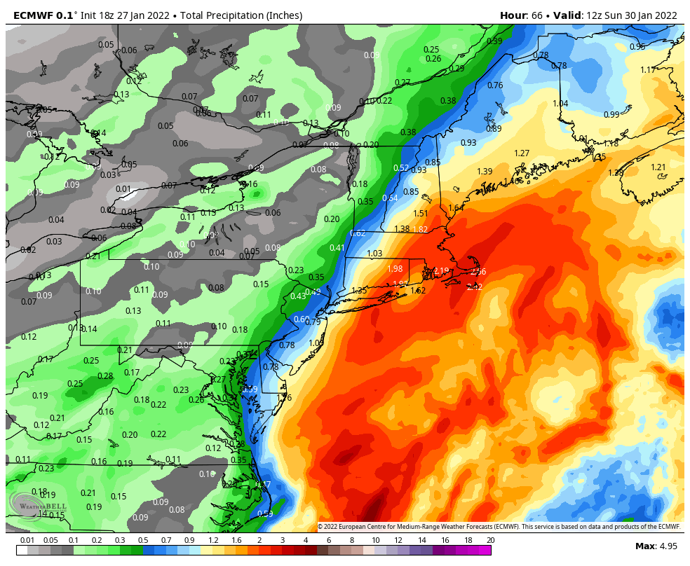
Heavier snow should begin spreading northward late Friday into Saturday morning. This will be heaviest across Eastern NJ and Long Island. The bands of heavier snow will gradually oscillate and pivot back westward closer to the NYC Metro and Northeast NJ at times. This will be especially true on Saturday morning.
The true inflection point in the forecast will come late Saturday morning into Saturday afeternoon. If the storm tracks further west, heavier snow bands may reach Long Island and the NYC Metro. If it tracks further east, snowfall intensity will begin to lighten up.
By Saturday evening, snow intensity should begin to decrease from west to east – lasting longest across Long Island as the storm system begins to wrap up to the east. Light snow may linger on parts of Long Island until Sunday morning.
Snowfall Totals and Uncertainties
The current snowfall forecast includes the 25th to 75th percentile forecast. As you may notice, the ranges on this forecast are unusually high. There is a tremendous amount of uncertainty regarding the forecast for this lead time, specifically near the NYC Metro.
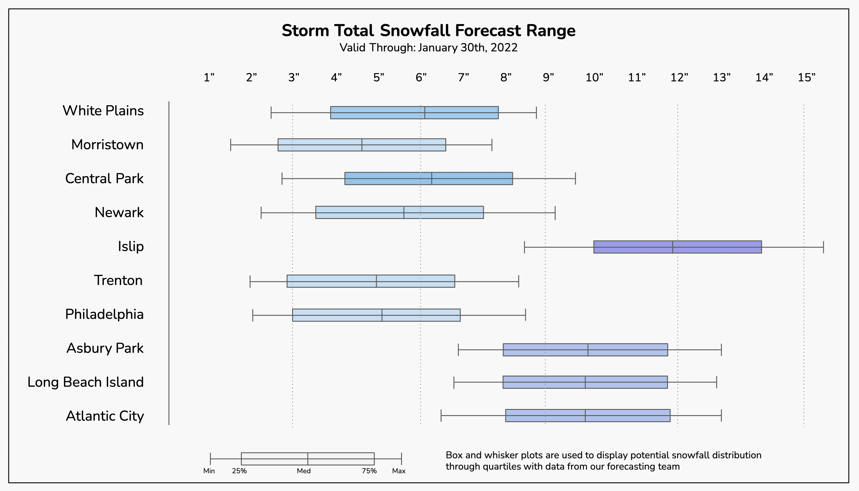
We anticipate hte highest snowfall totals locally to be across Eastern NJ (the NJ Shore) and Central/Eastern Long Island. NYC will, again, be right on the heavy snowfall gradient. Lighter snowfall totals are anticipated across Northern NJ and Southeast NY.
A final update to the snowfall forecast will be provided on Friday morning. Until then, hang tight with us – we appreciate your patience, this is a tough forecast.
Leave a Reply
Want to join the discussion?Feel free to contribute!