-2")
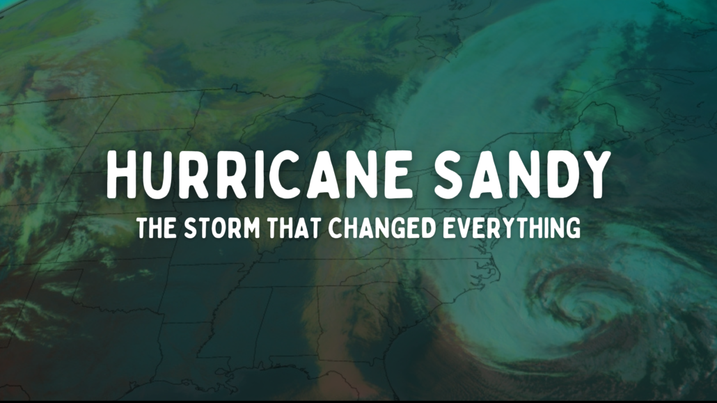
On Hurricane Sandy, the storm that changed everything
On October 24th, 2012, the vibe changed.
I can still remember exactly how it felt as I propped up in my office chair and leaned in a little closer to the computer screen, making sure that what I was seeing on weather model data wasn’t my mind playing tricks on me.
It wasn’t.
That afternoon, forecast model data began showing a scenario in which Tropical Storm Sandy (which had recently formed in the Caribbean) would make an unprecedented recurve to the west in the Atlantic Ocean and head towards New Jersey. In the days prior, a few forecast models had suggested this as a possibility (mainly the European model) but the probability of such a scenario unfolding remained quite low.
On that Wednesday, however, the number of weather models showing such a scenario suddenly increased. It was time to start paying attention. I got to work, penning an article in which I would try to carefully toe the line between providing information and not causing any panic. “Concern builds as Tropical Storm Sandy provides a forecasting headache”, it read.
That would turn out to be a dramatic understatement. Seven days later, on October 29th, 2012, post-tropical Sandy would make landfall near Brigantine, New Jersey. It would reshape the coastline of New Jersey and New York with high winds, torrential rain and storm surge, causing $65 billion in damage and taking the lives of near 100 local residents. It would bring nightmare, worst-case scenario forecasts to reality.
It would change everything.
October 22 – October 24: “Something just feels different here”
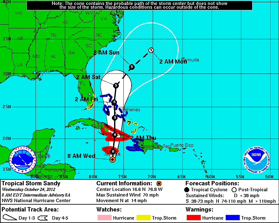
Tropical Storm Sandy formed late in the year, at the tail end of a well-above normal activity hurricane season in the Atlantic Basin. It was officially declared a Tropical Storm on October 22nd, 2012 in the Caribbean, and was expected to drift gradually northward in the days that followed.
On October 24th, 2012, the National Hurricane Center upgraded Sandy to a hurricane. The storm was expected to continue drifting northward towards Jamaica – which it did, before making landfall near Kingston with maximum sustained winds of 85 miles per hour. The future of the system remained unclear.
Initially, the impacts of the system on the United States mainland were expected to be quite minimal. The large majority of forecast model guidance suggested that Sandy would move northward from the Caribbean and be picked up by a trough and associated cold front in the Atlantic. This would curve the system northeastward into the open waters of the Atlantc, directing it away from the United States.
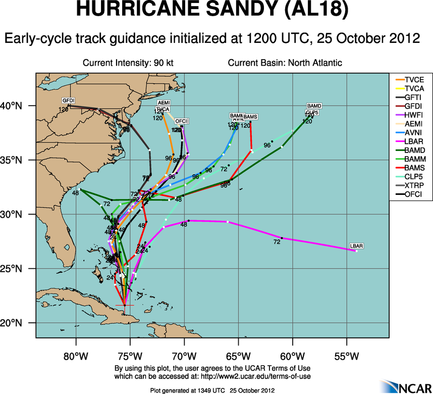
There was one issue – if Sandy missed that trough, the situation would become much more complicated. A large, anomalous blocking high pressure was forecast to settle into the North Atlantic behind it. This would make it nearly impossible for Sandy to move northeastward out to sea. Instead, the storm would be directed northward and then possibly even drift westward closer to the coast. There was even a scenario where a disturbance moving into the Ohio Valley would “capture” Sandy and tug the storm back westward into the coastline. The European model was the only model suggesting this possibility at the time.
On October 25th, weather model data was split in regards to the future of Hurricane Sandy. Several weather models suggested the storm would be swept eastward by the aforementioned roughing system into the Atlantic. But a growing number of models also suggested a more concerning scenario – where Sandy would move northward and be blocked by high pressure, only to be captured by an incoming disturbance and flung westward towards the New York and New Jersey coastline.
Even early on, though, something felt different. Even given an endless array of possible scenarios with most tropical cyclones, it is quite rare to see a clustering of models showing such an extreme scenario early on. I recall a conversation with some colleagues during this time frame. One of us remarked “something just feels different here”.
October 25 – October 26: Uncertainty grows and communication becomes critical
Meteorologists had a significant communication problem. There were two distinct scenarios emerging as possibilities, and both of them had drastically different impacts on the United States. Specifically, here in the NYC Metro area, one scenario would lead to a major event while the other would result in nothing at all.
How do you communicate such a thing? After some debate, I decided that it was time to be honest – we didn’t know what was going to happen. For so long, meteorologists have spent their time trying to convince everyone that they always know what’s coming. The honest truth is that sometimes we don’t. In situations like this, honesty goes a long way.
On October 25th, we published “Growing concern for high impact event as Sandy targets the East Coast”, which included details on the individual scenarios and possibilities for Sandy’s impact along the East Coast. One of the main points of discussion was the growing possibility of an impactful event in the local area.
That evening, Sandy made landfall as a Category 2 Hurricane near Santiago De Cuba. The impacts were significant – with strong winds, torrential flooding rains and storm surge. Closer to home, the situation was also growing more dire as more and more forecast models began to suggest that Sandy was not going to head out to sea.
As we mentioned earlier, the meteorological setup transpiring with Sandy was highly anomalous and complex. It now appeared more likely that Sandy would miss the chance to be swept up and recurve away from the United States. This left the storm with no choice but to drift northward into Western Atlantic Ocean. A large ridge of high pressure to the north of the storm would block any seaward curve.
Meanwhile, data was coming into better agreement on the approach of a second storm system which was surging southeastward through the Mississippi Valley and towards the East Coast. This is where the worst case scenarios came into play – with Sandy a sitting duck off the coastline, this system could easily surge eastward to capture it and rip it back towards the coastline.
Forecast model guidance began to signal the growing possibility of this scenario – with several members showing a rapid drop in the storms central pressure and a growing collection of models suggesting that the storm would surge westward and make landfall in New Jersey or New York. This would put our local area in a highly vulnerable position for wind and storm surge.
October 27 – October 29: A historic storm impacts the area
In what seemed like just a few hours, the forecast went from uncertain to highly concerning. All forecast models suddenly agreed that Sandy would be captured and swing inland, bringing the full force of the storm into New Jersey and the NYC Metro Area. For the lack of any better verbiage: Sh*t was getting real.
The next few days would be a whirlwind. Government agencies sprung into action, issuing emergency declarations, closing airports, shutting down public transportation, and urging mandatory evacuations. Local residents boarded up windows and prepared for flooding and strong winds. Some evacuated, some didn’t. Some had no choice but to stay.
Meteorologists began urging residents to take the storm seriously. Two days prior to Sandy’s landfall in an article on our main website, I wrote:
“A storm of record breaking size will take an unprecedented track from the Western Atlantic Ocean back to the US East Coast, likely making landfall on the New Jersey Shore late Monday Night into early Tuesday Morning. None of us have seen a storm similar to the one we are set to experience over the next few days.”
I remember a dramatic influx in traffic and questions during the few days prior to Sandy’s impact. Radio interviews, TV spots, and more. I felt a responsibility to provide accurate and reliable information without causing people any more stress than they already were experiencing. It was a tough, trying few days with no more than an hour or two of sleep sprinkled in.
And then the storm hit. Weeks of preparation were over. It was here.
The loudest silence.
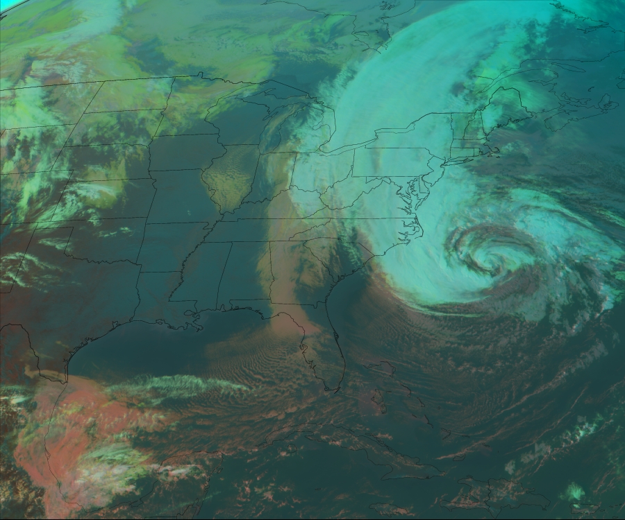
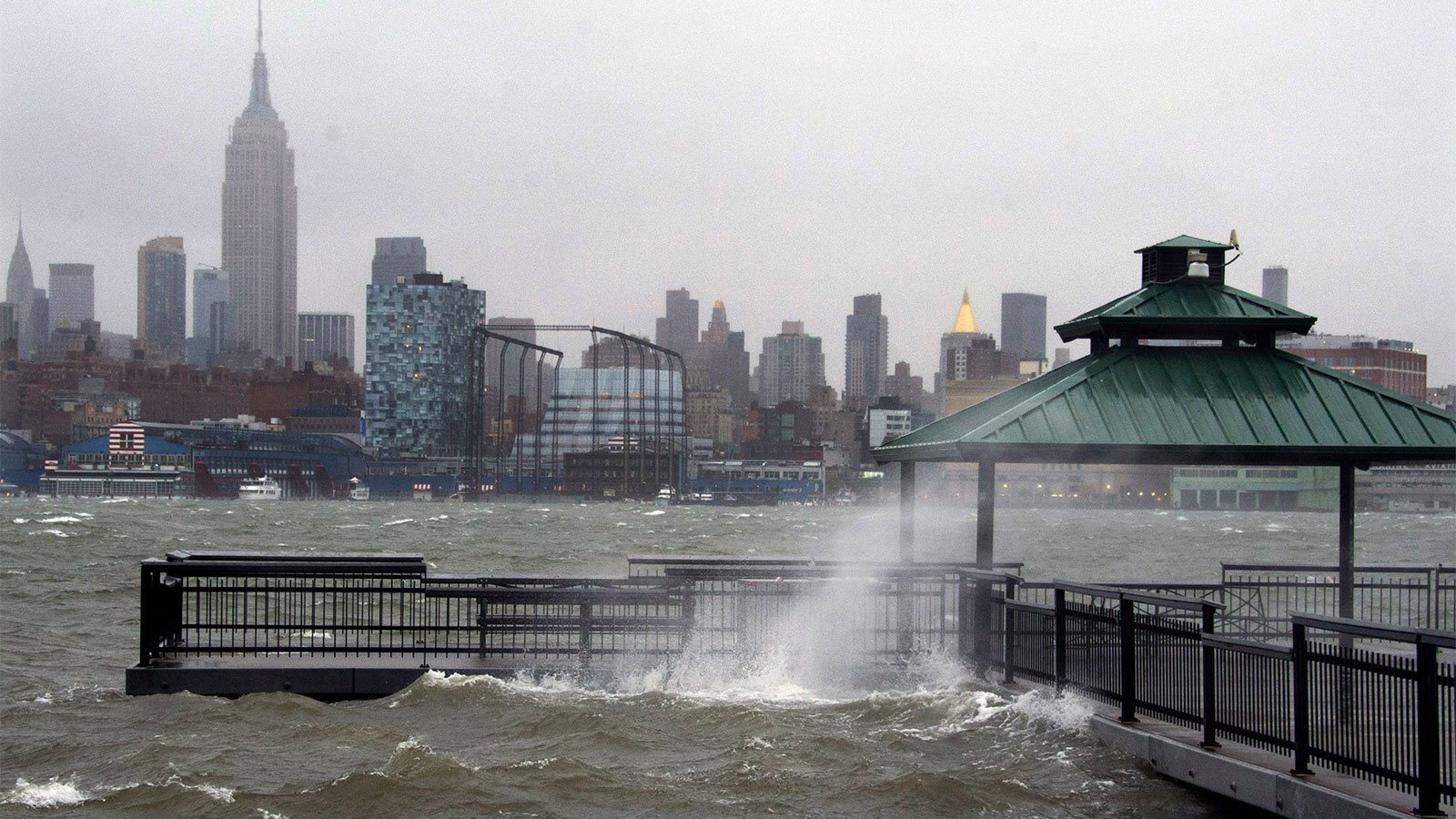
The flooding began early, thanks to a full moon and poorly timed tidal cycles. Heavy rains and onshore flow allowed water to pour into the New Jersey coast and even parts of New York and Long Island. Images from Cape May, Stone Harbor and Red Hook – among many other places – began pouring in, showing extremely high water levels. The storm was still hundreds of miles offshore.
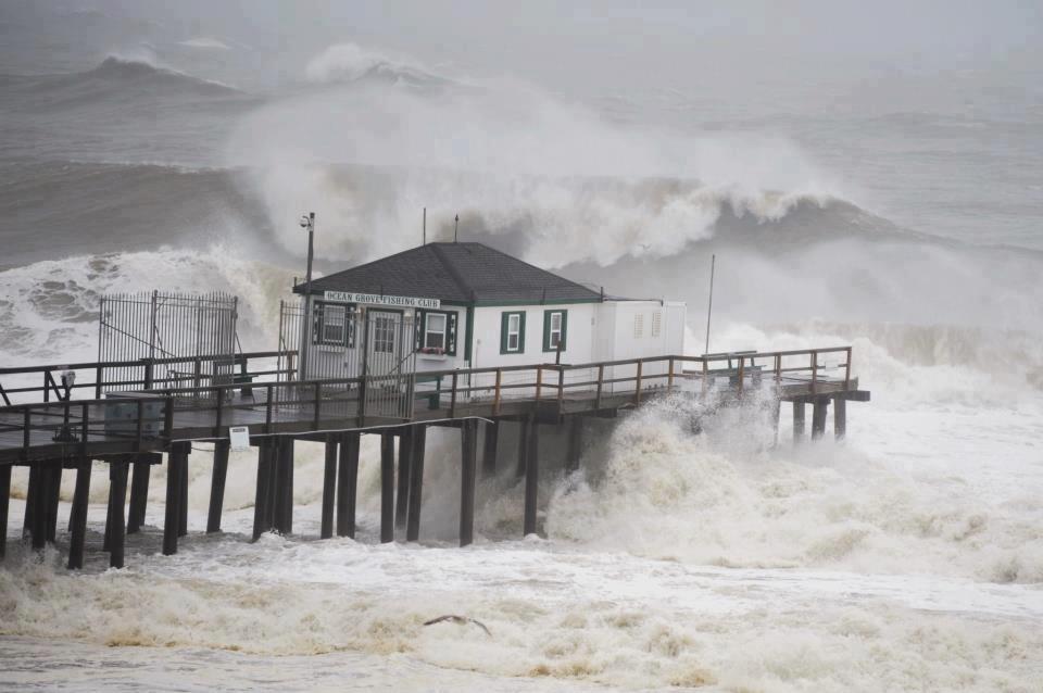
Like many of us, I sat back and watched in horror as the storm changed the landscape of the New Jersey and New York coastlines forever. I watched as peoples homes flooded and were washed away. I watched as roadways were overtaken with water. I watched the power go out in the city, the subways flood. Watched hundred-year-old oak trees fall onto neighbors homes in my parents neighborhood. Watched as tidal records were set and the storm surge piled in.
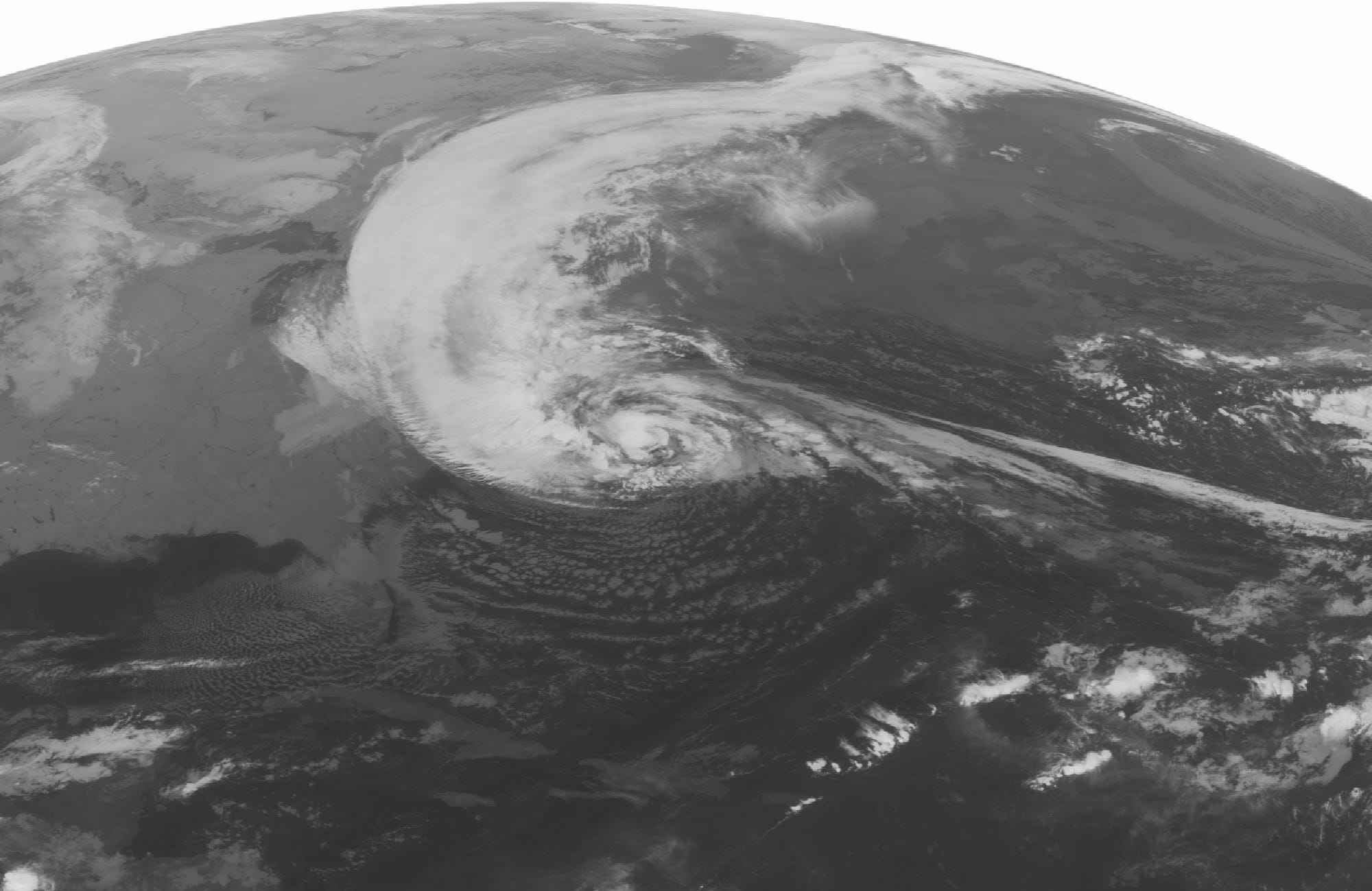
Hurricane Sandy’s capture and recurve into the New Jersey coast was an incredible meteorological event. The atmospheric dynamics at play were historic for any part of the world, and they were occurring right in our backyard. We wrote about the systems dynamics and very low pressure a few years after the storm on our website.
I felt a sense of awe and a feeling of amazement at the power the storm was displaying. I felt guilt for feeling that. I felt sadness. I felt hopeless. Had I done enough to help people prepare? How fortunate was I to be sitting in a house while others had been displaced, or were soon to find their home no longer existed? What was there to forecast now? The winds kept howling. The emotions, the images, the sounds kept coming. All at once. The loudest silence.
And then it was over.
October 30: A long recovery process begins
The morning of October 30th, 2012 brought the damage to light. It was worse than we had imagined, and it would take years to clean up and even longer to fully recover. This was especially true along the areas coastline where the damage was clearly the worst, but also apparent even inland where tens of thousands of trees had fallen and power would not be restored for days.
In the months that followed, the spirit of the NYC Metro area, New Jersey and surrounding states would be tested – and would emerge stronger than ever, time and time again. The recovery was long and it was certainly not easy, but the fortitude of the residents of this area has never been in doubt. Over time, we cleaned up, we recovered, and we rebuilt. That’s what we do.
There are several images and scenes that I will never forget from this storm, but one sticks out in particular: The constant hum of generators powering homes for days after the system had departed. With hundreds of trees down blocking the roadways and no power, it truly felt apocalyptic. In the days after the storm, the streets would be filled with neighbors just wandering, walking around and looking at the damage. There was nowhere to go and nothing to do other than see if anybody around us needed help. This familiar scene played out in countless neighborhoods around the area, the damage worse in some places than others.
Soon after the storm hit, it became clear that many residents were not prepared for the storm systems impacts. The recurring theme among folks we spoke with was inconsistent communication and a lack of understanding as to what was going on. I took that personally – how was it possible that the general public was confused when we had seven days of warning that this storm could impact us? The ball had been dropped somewhere along the way.
It was time to start cleaning up our communication, to be more direct in regards to uncertainties and preparedness. And so, New York Metro Weather as you know it today was born – with a focus on hype-free, community-based forecasts that are easy to understand and act upon.
October 2022: Are we better off with lessons learned, or likely to be unprepared yet again?
Hurricane Sandy was, in many ways, the storm that brought a nightmare to reality. Ten years later, the effects of the storm are still cascading through our daily lives. Millions of local residents have taken the time to become more familiar with the storms that threaten our coastline and say that they will be more prepared should another one come along.
But are we really more prepared? As a meteorologist, I’m not so sure. Just last year, as the remnants of Hurricane Ida made their way up the coast, New Yorkers were thrust into what seemed like the fifth “once in a century” flood in the past decade. The resounding thought as the waters receded? We weren’t prepared. Government officials blamed meteorologists for getting the forecast wrong (spoiler alert: we didn’t get the forecast wrong). Residents said they had no idea such an event was going to occur. An all-too-familiar sound.
The issue, as it was with Sandy, was poor communication and a lack of direction. Somewhere along the way, the line of communication continues to be broken between what we understand as possible meteorological impacts from these storms and how we can adequately prepare for it. This is true for storms of all kinds: Thunderstorms, winter storms, hurricanes, hybrids.
As meteorologists, our job is to be honest and communicate the risks and uncertainties that come along with these systems as best as we possibly can. Doing this in a way that the general public can understand and digest the information is the most critical thing. Information is of no value if the people that we are providing it to can’t understand or act upon it.
It’s our job – and should be our goal – to get better at providing information that is accurate, dependable and actionable. That’s how we’ll ultimately improve our preparedness for the seemingly growing number of powerful storms like Sandy, and that’s how we’ll be better prepared the next time a storm system like Sandy comes around.
Closing thoughts and a moment of nostalgia
Ten years after Hurricane Sandy, I can confidently say that I remain humbled by the weather every single day. Looking back on Sandy itself, I remain overwhelmed by the power of the system and the chaotic events in the days leading up to it. So many people did incredible work getting the word out regarding the storms potential impacts – from meteorologists to news stations and government officials. While we may not have been as prepared as we would have liked, having seven days of warning time for a storm system is an incredible feat.
I still feel a lingering sadness while researching this event a decade later. So much damage, hundreds of lives lost. The images will never get easier to look at. But these days, there is a feeling of positivity that takes over at the end that leaves me feeling rejuvenated. We’ve come a long way. I’d like to think we’ve learned a lot both from Sandy and the impactful weather events that have followed.
New York Metro Weather continues on even after all of these years, too. When and if the next Sandy comes around, you can bet your bottom dollar that we will be here with you, as always.
Hurricane Sandy was the storm that changed everything. If we continue our work to understand, respect and prepare for these storms, it will have ultimately changed things for the better.
If you’d like to look back at our coverage leading up to Hurricane Sandy, check out the links below:
Long Range: High latitude blocking could set off major changes
Hype meter rising on potential weekend storm: What’s the deal?
Concern builds as Tropical Storm Sandy provides forecasting headache
Growing concern for high-impact storm as Sandy targets East Coast
Hurricane Sandy to bring widespread impacts to our area
Dangerous Hurricane Sandy set to slam into the area
Hurricane Sandy Video Update #1
baran aydin
türk kahvesinin faydaları
Only wanna input that you have a very decent web site , I enjoy the design and style it really stands out.
Hurda bakır alan istanbul hurdacı firması olarak her türlü madeni değerinde alıyoruz.