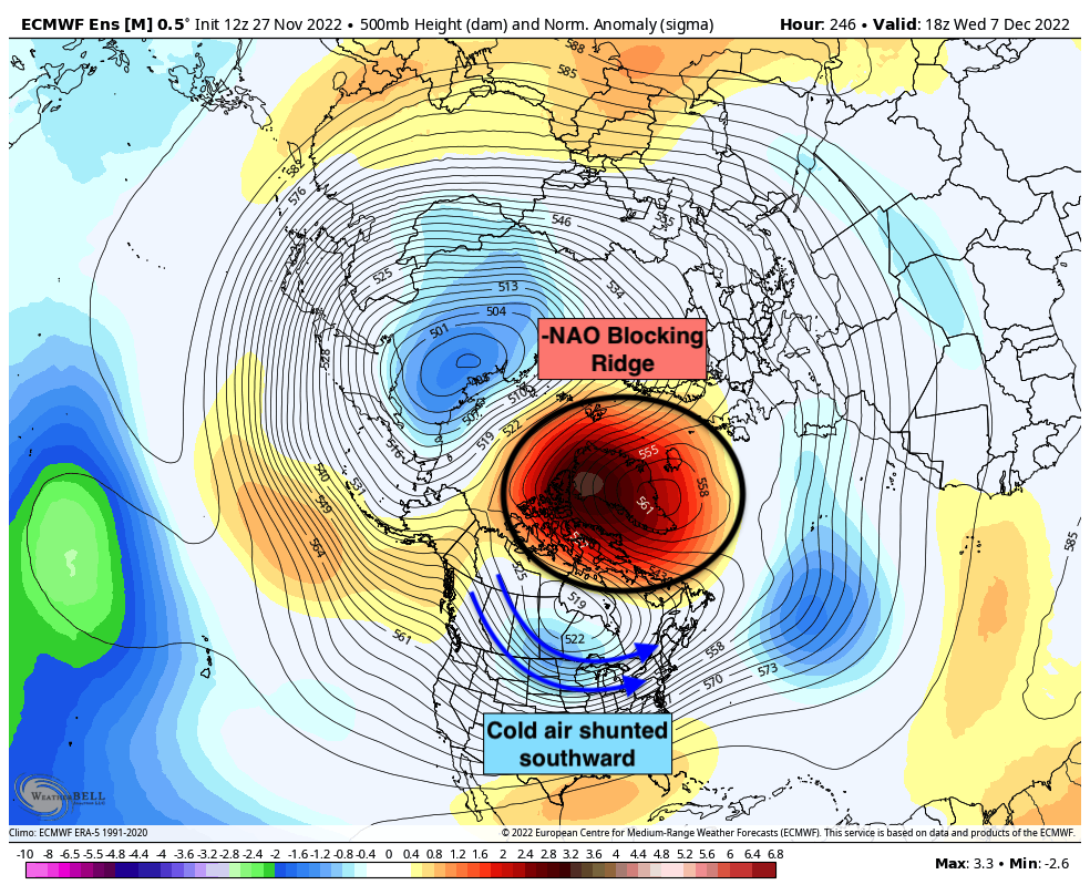
When it comes to the weather in the Northern Hemisphere, you’d better keep your head on a swivel. If you’re not paying close enough attention to what’s going on around you, you’ll fall behind the forecast very quickly. In this case, strong high pressure developing over Greenland will serve as a warning shot that a colder and more wintry weather pattern will arrive in NYC by mid-December.
https://www.nymetroweather.com/wp-content/uploads/2022/01/jeffrey-blum-5v1QSY62ZBs-unsplash-2.jpg00John Homenukhttps://www.nymetroweather.com/wp-content/uploads/2024/02/Empire-2000-x-300-px-2.pngJohn Homenuk2022-11-28 18:14:522022-11-28 18:14:56How anomalous high pressure developing over Greenland could signal the start of a cold and wintry pattern in NYC
Rain is moving out of the area this evening, and conditions are forecast to improve as we move into the overnight period. The storm system which produced the rainfall and unsettled weather will be long gone by the time Monday morning arrives. Monday is expected to be characterized by slightly warmer than normal temperatures (highs in the mid 50s) and plenty of sunshine.
Pleasant weather will continue into Tuesday, but high temperatures will be significantly cooler than the days prior and are only expected to reach the upper 40s. A cool breeze will be a noticeable feature during the day, but sunshine will keep weather conditions pleasant.
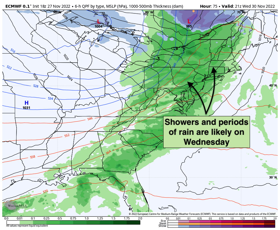
The forecast trends unsettled as we move towards midweek. A low pressure system is forecast to amplify and strengthen into Southeast Canada with moisture increasing and moving into the area once again. Showers and unsettled weather are anticipated on Wednesday as a result, with some periods of steady and occasionally heavy rain also possible. Unsettled conditions could also continue into Wednesday night.
It’s possible that this storm system could also include some stronger wind gusts. Forecast models have waffled back and forth on exactly how strong these wind gusts will get, but occasional gusts over 30mph are currently expected especially on Wednesday night as the frontal system moves through.
The good news? The storm system will be in and out, with conditions clearing out by Thursday. Temperatures will cool down, but we’re expecting lots of sunshine from Thursday into the weekend with high pressure in control. Pleasant weather will continue through at least Sunday.
Long range forecast trending colder and more active
Forecast model data is in excellent agreement that as we move into early December, a significant blocking ridge will develop over Greenland – also known as a negative NAO, or negative North Atlantic Oscillation. These blocking ridges are notorious for leading to colder and more active weather across the United States.
Ridging that develops over Greenland and the North Atlantic displaces cold air that typically resides in those areas further south. It also acts as a block (hence the term “blocking ridge”) and allows storm systems to strengthen near the Northeast United States.
As a result, -NAO blocking ridges are often associated with cold and wintry patterns in the NYC Metro. It remains to be seen if this pattern will bring the same results. While wintry conditions aren’t guaranteed, it’s important to note that chances for wintry weather will likely be much higher than normal by the time we approach mid-December.
We have a more detailed breakdown on the anticipated evolution of the weather pattern coming in the next day or two. For now, enjoy the warmth… and stay tuned.
https://www.nymetroweather.com/wp-content/uploads/2022/11/jorge-ramirez-e4r7Ocy1pKM-unsplash-scaled.jpg18592560John Homenukhttps://www.nymetroweather.com/wp-content/uploads/2024/02/Empire-2000-x-300-px-2.pngJohn Homenuk2022-11-27 19:22:362022-11-27 19:22:39NYC Forecast: Nice weather surrounds a midweek storm, long range forecast trending colder and active
New York Metro Weather was once simply a blog. On blogspot. Yup, we’re that old.
Things changed for us in 2009 when we made one of our best decisions ever – we signed up for Twitter. In the 13 years that followed, we have been fortunate enough to build an incredible community together. We’ve tracked hundreds of storms – Hurricane Sandy, the remnants of Ida, several blizzards and many days of wildfire smoke. We’ve complained about the warmth, learned to love the dew point and have enjoyed lots of 10/10 days in between.
https://www.nymetroweather.com/wp-content/uploads/2022/01/s-ViGTTgat4EM-unsplash-scaled.jpg17072560John Homenukhttps://www.nymetroweather.com/wp-content/uploads/2024/02/Empire-2000-x-300-px-2.pngJohn Homenuk2022-11-18 11:31:132022-11-18 12:10:17What happens to New York Metro Weather if Twitter goes away?
https://www.nymetroweather.com/wp-content/uploads/2022/11/dan-calderwood-auri102juYU-unsplash-scaled.jpg17072560John Homenukhttps://www.nymetroweather.com/wp-content/uploads/2024/02/Empire-2000-x-300-px-2.pngJohn Homenuk2022-11-12 21:49:372022-11-12 21:49:41Much colder air on the way to NYC next week
Hi friends! Our website uses cookies to provide an optimal browsing experience for you. New "Cookie Consent" laws mandate us to inform you of this. As long as you're cool with it, just hit OK. You'll only see this message once.
We may request cookies to be set on your device. We use cookies to let us know when you visit our websites, how you interact with us, to enrich your user experience, and to customize your relationship with our website.
Click on the different category headings to find out more. You can also change some of your preferences. Note that blocking some types of cookies may impact your experience on our websites and the services we are able to offer.
Essential Website Cookies
These cookies are strictly necessary to provide you with services available through our website and to use some of its features.
Because these cookies are strictly necessary to deliver the website, refusing them will have impact how our site functions. You always can block or delete cookies by changing your browser settings and force blocking all cookies on this website. But this will always prompt you to accept/refuse cookies when revisiting our site.
We fully respect if you want to refuse cookies but to avoid asking you again and again kindly allow us to store a cookie for that. You are free to opt out any time or opt in for other cookies to get a better experience. If you refuse cookies we will remove all set cookies in our domain.
We provide you with a list of stored cookies on your computer in our domain so you can check what we stored. Due to security reasons we are not able to show or modify cookies from other domains. You can check these in your browser security settings.
Other external services
We also use different external services like Google Webfonts, Google Maps, and external Video providers. Since these providers may collect personal data like your IP address we allow you to block them here. Please be aware that this might heavily reduce the functionality and appearance of our site. Changes will take effect once you reload the page.
-2")