-2")
NYC Forecast: Nice weather surrounds a midweek storm, long range forecast trending colder and active
Rain is moving out of the area this evening, and conditions are forecast to improve as we move into the overnight period. The storm system which produced the rainfall and unsettled weather will be long gone by the time Monday morning arrives. Monday is expected to be characterized by slightly warmer than normal temperatures (highs in the mid 50s) and plenty of sunshine.
Pleasant weather will continue into Tuesday, but high temperatures will be significantly cooler than the days prior and are only expected to reach the upper 40s. A cool breeze will be a noticeable feature during the day, but sunshine will keep weather conditions pleasant.
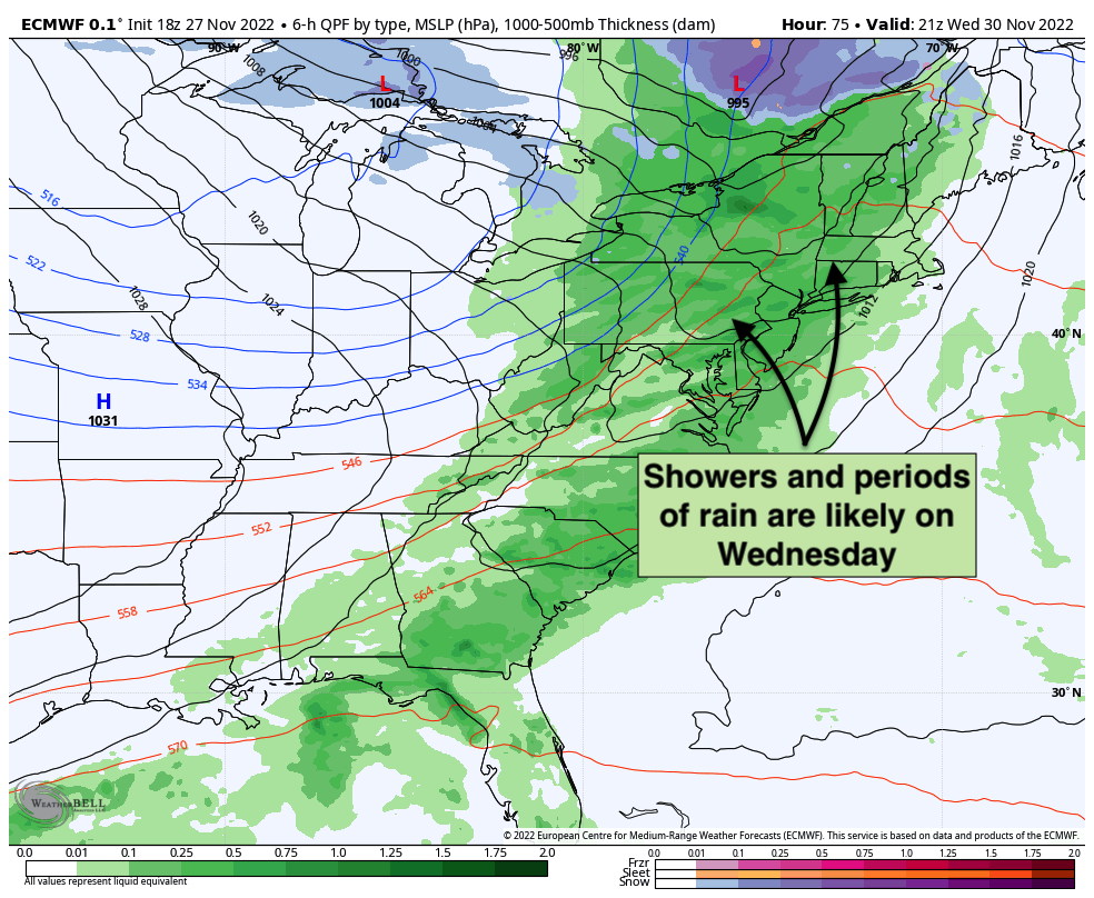
The forecast trends unsettled as we move towards midweek. A low pressure system is forecast to amplify and strengthen into Southeast Canada with moisture increasing and moving into the area once again. Showers and unsettled weather are anticipated on Wednesday as a result, with some periods of steady and occasionally heavy rain also possible. Unsettled conditions could also continue into Wednesday night.
It’s possible that this storm system could also include some stronger wind gusts. Forecast models have waffled back and forth on exactly how strong these wind gusts will get, but occasional gusts over 30mph are currently expected especially on Wednesday night as the frontal system moves through.
The good news? The storm system will be in and out, with conditions clearing out by Thursday. Temperatures will cool down, but we’re expecting lots of sunshine from Thursday into the weekend with high pressure in control. Pleasant weather will continue through at least Sunday.
Long range forecast trending colder and more active
Forecast model data is in excellent agreement that as we move into early December, a significant blocking ridge will develop over Greenland – also known as a negative NAO, or negative North Atlantic Oscillation. These blocking ridges are notorious for leading to colder and more active weather across the United States.
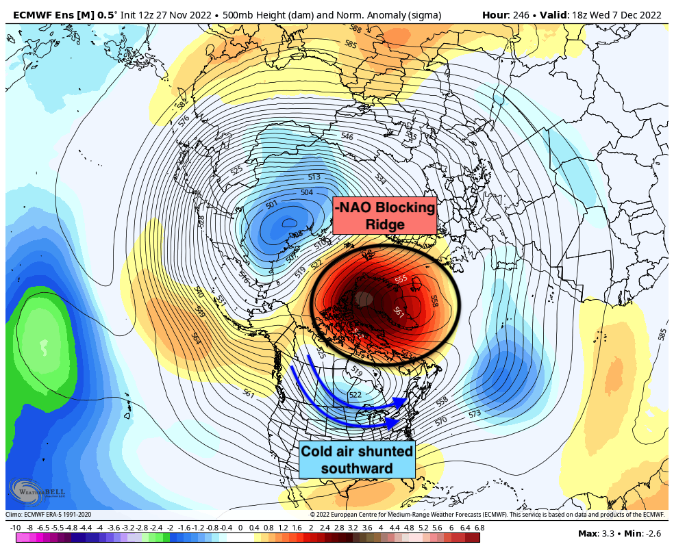
Ridging that develops over Greenland and the North Atlantic displaces cold air that typically resides in those areas further south. It also acts as a block (hence the term “blocking ridge”) and allows storm systems to strengthen near the Northeast United States.
As a result, -NAO blocking ridges are often associated with cold and wintry patterns in the NYC Metro. It remains to be seen if this pattern will bring the same results. While wintry conditions aren’t guaranteed, it’s important to note that chances for wintry weather will likely be much higher than normal by the time we approach mid-December.
We have a more detailed breakdown on the anticipated evolution of the weather pattern coming in the next day or two. For now, enjoy the warmth… and stay tuned.
Usually I don’t read post on blogs, however I wish to say that this write-up very forced me to check out and do so! Your writing taste has been surprised me. Thank you, quite nice article.