-2")
Impactful storm system becoming likely in the days before Christmas
A large and impactful storm system is expected in the Central and Eastern US during the days leading up to Christmas. Widespread travel disruptions are a growing concern. In NYC, the main impacts from the system are expected to be rain and wind. Winter weather is possible in the interior Northeast.
For the last several days, model guidance has suggested the possibility of a strong storm system developing in the Eastern United States during the days before Christmas. Originally, it looked like strong high pressure and cold air would lead to a coastal storm. Theoretically, this would have opened the door to a wintry weather event in the NYC area.
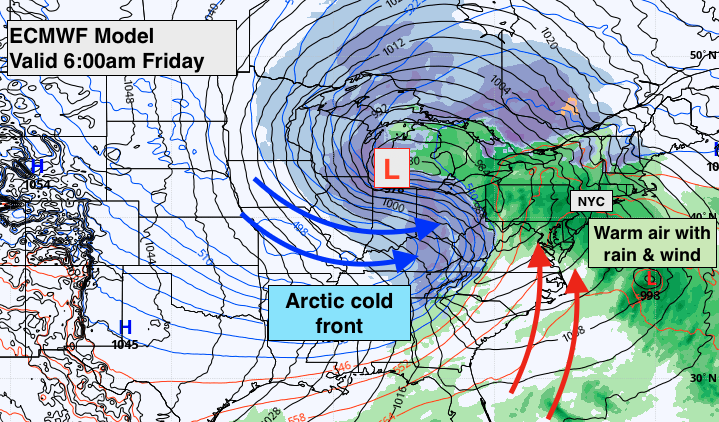
Recent model runs have trended decidedly against that idea, with high pressure remaining northwest of our area. This allows a strong storm system to form in the Central US, with warm air advecting up along the East Coast. The primary impacts from this storm system in the NYC area will be wind and rain.
How will the storm system develop?
A powerful disturbance will drop southward from Alaska into British Columbia early this week. The jet stream across Canada and the United States will eventually encourage this disturbance to amplify and strengthen further. As a result, a strong cold front will surge through the Plains and Midwest by midweek.
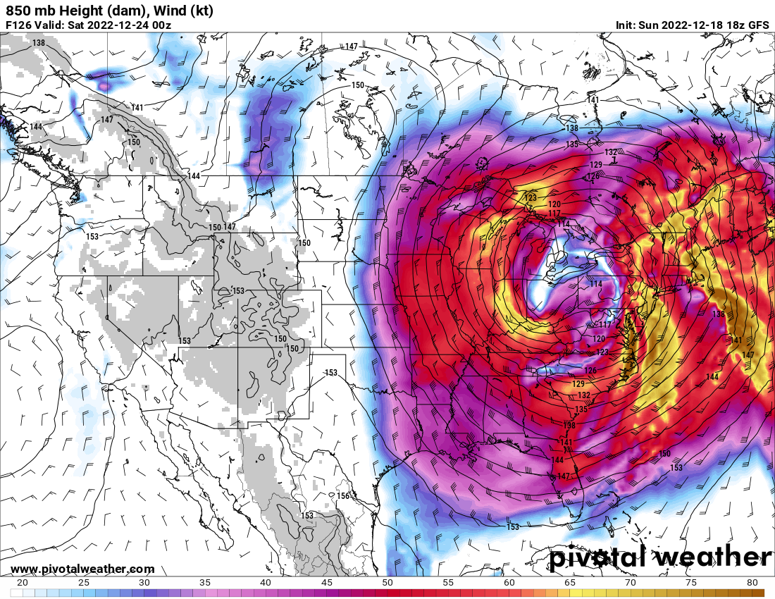
Eventually, a strong low pressure system will form on this front as the mid and upper level jet dynamics are enhanced further. The result will be a powerful low pressure system developing in the Midwest, Ohio Valley or Great Lakes by Thursday.
Strong winds and winter weather are likely from the Plains into the Midwest and Ohio Valley regions. Along the Eastern US coast, heavy rainfall and gusty winds are expected with warm air taking over.
In NYC, the expectation is that periods of heavy rain and gusty winds will impact the area from late Thursday into Friday. The potential exists for localized flooding, gusty winds and even an isolated thunderstorm. The extent of heavy rainfall and gusty wind potential is the main uncertainty at this juncture.
What kind of travel impacts can I expect?
While there are still many uncertainties in regards to exactly how this storm evolves, widespread travel impacts across the United States are a growing concern from Thursday into Friday. Forecast model guidance is consistently indicating that this will be a very large and strong storm system.
GFS and Euro ensemble data both suggest a powerful jet stream impacting the Plains, Great Lakes, Ohio Valley and Northeast states from Thursday into Friday. Anomalously strong winds at multiple levels (from as low as the surface to as high as 30,000 feet) are alm ost certain to create significant aviation issues.
If you have a flight planned from the second half of Thursday through Friday, the chance of travel related delays or difficulties is much higher than normal. If you have the flexibility to change it (before the storm on Wednesday or after it on Saturday), we recommend considering that option.
What are the expected day-to-day impacts in the NYC Metro?
The storm system is expected to impact the NYC Metro Area from Thursday into Friday. The timing and details of this system are still quite uncertain and subject to change, but here’s what we’ve got as of the most recent model data:
Wednesday: A fine day. No weather-related issues are anticipated. Clouds may begin to increase late in the day. Otherwise, business as usual.
Thursday: The storm begins to impact the Plains and Midwest states. Southerly winds will increase in the NYC Metro Area with cloud cover thickening up as the day goes on. By evening, periods of rain are expected. Heavy rain is possible by Thursday Night. South/southeasterly winds will increase and could become strong and gusty. Travel delays and difficulties will become increasingly likely during the second half of the day.
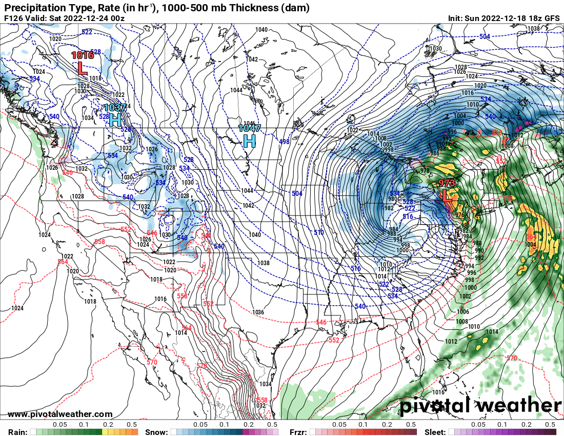
Friday: Periods of rain will continue and temperatures will eventually rise above normal for this time of year. Southerly winds will also increase. A winter storm will be evolving across the Great Lakes during this time. Eventually, a sharp line of heavy showers and gusty winds will move through the Northeast states – associated with an arctic cold front. Temperatures will fall dramatically behind this front. Travel impacts are very likely.
Saturday: Blustery and much colder conditions are expected, but overall weather conditions will slowly improve. Residual travel delays and difficulties are possible.
Stay tuned over the next few days as the details of the storm system come into better focus. Confidence on the intricacies of the system – including the timing, rainfall amounts and wind gusts in NYC, as well as national travel impacts – will increase during the next 24-48 hours.
türk kahvesinin faydaları
Whats up very nice website!! Guy .. Beautiful .. Wonderful .. I will bookmark your site and take the feeds also…I am glad to find so many useful info right here within the publish, we want develop extra techniques in this regard, thank you for sharing.
I’m curious about the mechanics behind Sprunki Phase 7: Ongoing Onslaught. Is there a hidden combo? The visuals during the transition look sus, like there’s an easter egg. Love it!
Trying out Sprunki Phase 7: Ongoing Onslaught right now. That beat drop in the middle is fire! Love how the characters react to the rhythm. Definitely my new favorite phase.
As someone who’s played many Sprunki mods, Sprunki Phase 7: Ongoing Onslaught finally nails the difficulty curve. The new mechanics add strategic depth without being overwhelming. GG to the devs!