A major nor’easter will develop on Monday, shifting from the Mid Atlantic states towards New England. Periods of heavy rain will occur in New York City starting Monday afternoon and continuing through Tuesday morning, with localized flooding and gusty winds. A changeover to snow is *possible* on Tuesday, but the details on the changeover remain highly sensitive to the storms track and intensity.
https://www.nymetroweather.com/wp-content/uploads/2023/03/valou-_c-U7ExImpZMME-unsplash-1-scaled.jpg17072560John Homenukhttps://www.nymetroweather.com/wp-content/uploads/2024/02/Empire-2000-x-300-px-2.pngJohn Homenuk2023-03-12 17:03:322023-03-12 17:03:37Major nor’easter forms Monday with rain, wind and even snow possible in NYC
Periods of snow are likely in NYC from Friday evening through Saturday morning with light accumulations. More substantial accumulations will occur in the interior and higher elevations. Attention will then turn to another potential storm system early next week which may be larger and more impactful.
A weak storm system will approach the NYC area on Friday afternoon, with precipitation beginning as rain in the city and along the coast. A rain and snow mix will begin on Friday afternoon and evening. In the city, snow may struggle to accumulate even on Friday night with warm temperatures at the surface leading to melting.
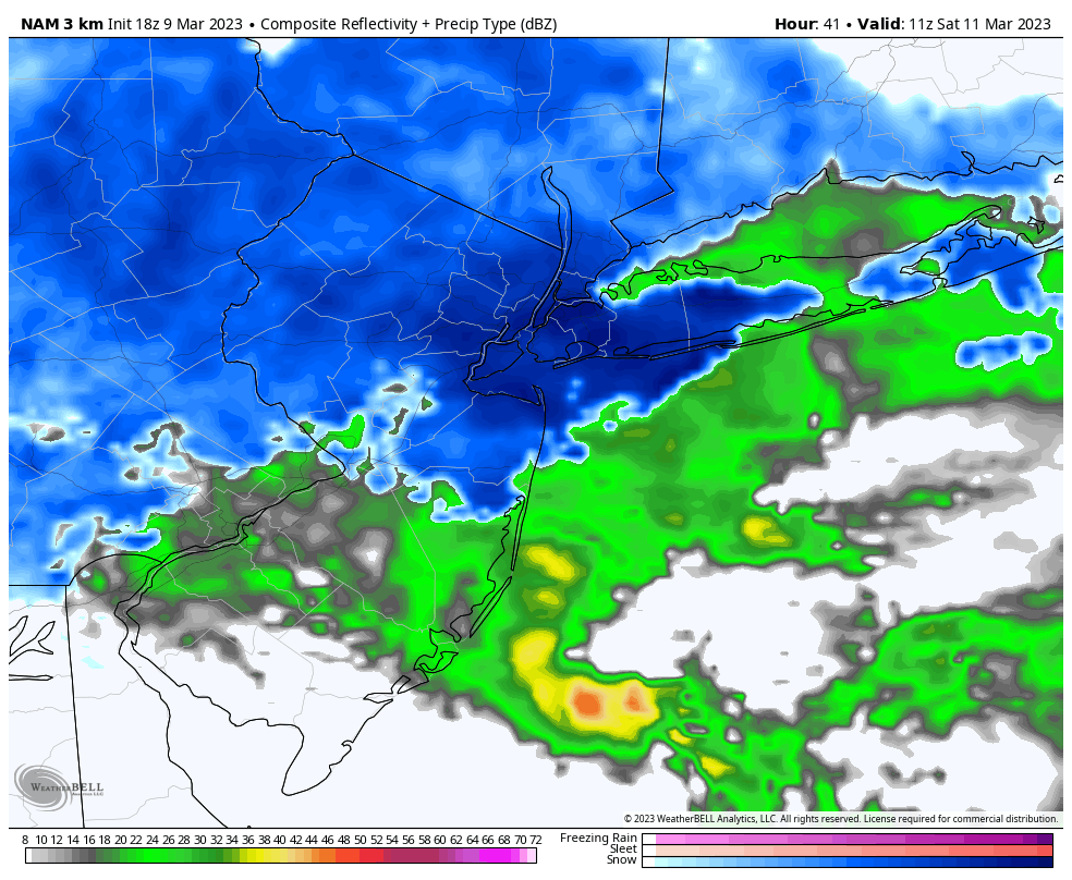
NAM model suggesting a change to snow in the NYC Metro on Saturday morning
By the early morning hours of Saturday, snowfall intensity will pick up while temperatures fall. Light snowfall accumulations will occur even in the NYC Metro area and along the coast. A trace to 2″ of snow is forecast in the NYC Metro before snow wraps up late Saturday morning.
Just a few miles inland from the coast – and in the higher elevations especially – snow will begin to accumulate later on Friday night and continue to do so into Saturday morning. Temperatures will fall quicker here than they do along the coast, with accumulations occurring more rapidly. 3 to 5 inches of snow is possible in these locations. Locally higher amounts can’t be completely ruled out, especially in the mountains of Northern New Jersey.
Larger, more impactful storm possible early next week
As snow wraps up on Saturday morning and afternoon, attention will turn to a more substantial storm system which may form early next week. Forecast model guidance has hinted at the development of a powerful coastal low from Monday into Tuesday. While the track of this system is still highly uncertain, this system certainly has a higher-impact ceiling than the light snow event on Friday.
The system is forming as a result of an atmospheric phase, or the combination of two storm systems in the mid and upper levels of the atmosphere. How quickly those two disturbances phase is the major question. A faster and more “clean” phase will bring the storm closer to the coast and lead to more notable impacts on the weather in NYC. A slower or sloppier phase will allow the storm to slip away, with the most notable impacts occurring in New England or perhaps even offshore.
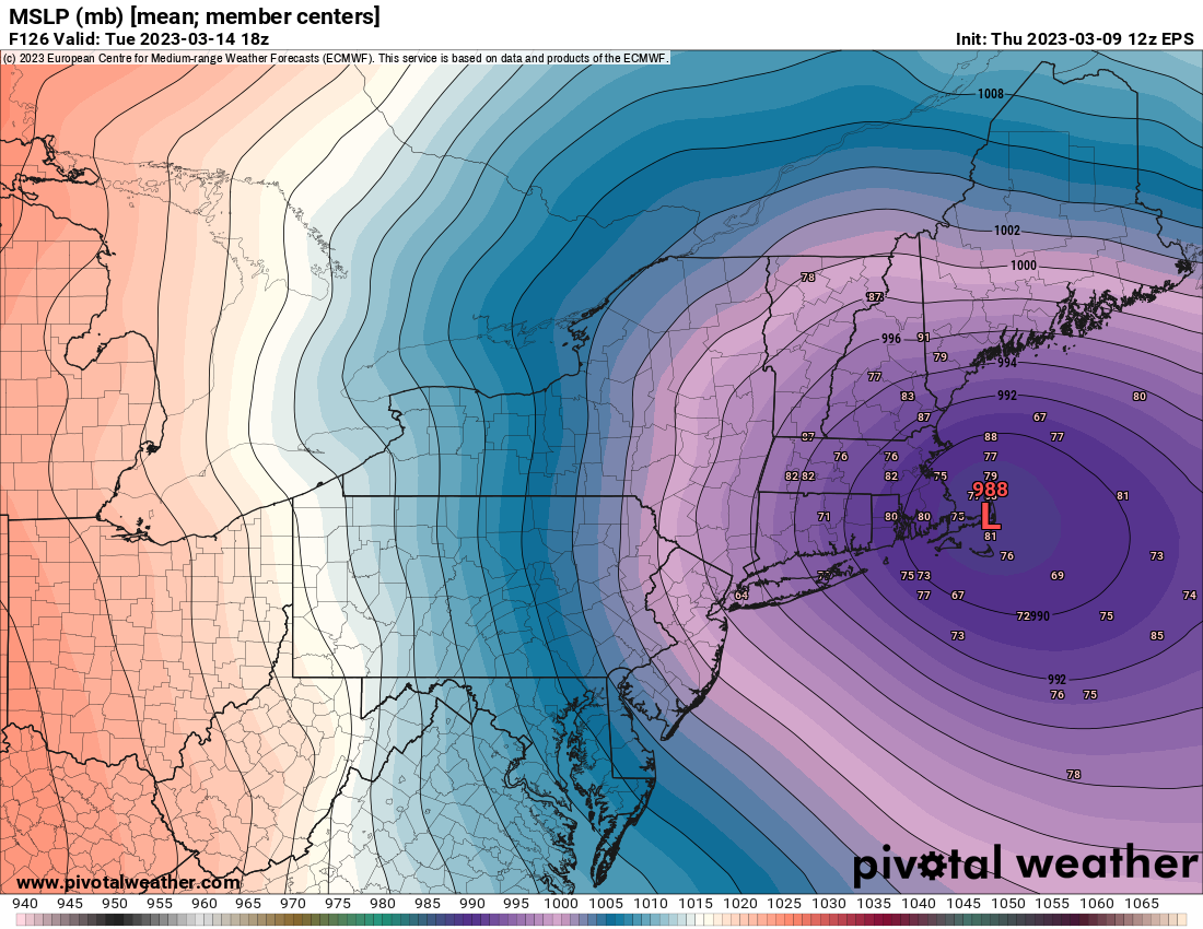
Ensemble data suggests a strong storm is possible from Monday into Tuesday
These are situations where we like to use ensemble data in order to get a better picture of how the storm may play out. The GFS and European model both have ensembles, or a handful of members (30 and 51, respectfully) that are run in addition to the main weather model. This offers meteorologists some clues into the envelope of possibilities as well as what the most likely outcomes are.
In this case, ensembles are split in regards to the systems track and offer a wide range of possibilities regarding the storms strength. Some keep the system weaker and offshore, while others bring it much closer to the coast and strengthen it significantly leading to more notable weather impacts for our area.
We won’t know the details of this system with any confidence for a few days. Still, we’ll start to get a much better picture of how the storm may play out in the coming days and especially as we head into Saturday. Forecast model guidance generally begins to show less spread between possible outcomes as we get within 2 to 3 days of the storm system itself.
At the moment, the forecast carries a mixture of snow and rain from Monday evening into Tuesday along with the possibility of blustery winds. Stay tuned for further updates in the coming days.
https://www.nymetroweather.com/wp-content/uploads/2023/03/jack-cohen-bUNOr0x8BSA-unsplash-scaled.jpg14402560John Homenukhttps://www.nymetroweather.com/wp-content/uploads/2024/02/Empire-2000-x-300-px-2.pngJohn Homenuk2023-03-09 18:20:032023-03-09 18:20:08Snow likely in NYC Friday evening, larger storm possible early next week
Hi friends! Our website uses cookies to provide an optimal browsing experience for you. New "Cookie Consent" laws mandate us to inform you of this. As long as you're cool with it, just hit OK. You'll only see this message once.
We may request cookies to be set on your device. We use cookies to let us know when you visit our websites, how you interact with us, to enrich your user experience, and to customize your relationship with our website.
Click on the different category headings to find out more. You can also change some of your preferences. Note that blocking some types of cookies may impact your experience on our websites and the services we are able to offer.
Essential Website Cookies
These cookies are strictly necessary to provide you with services available through our website and to use some of its features.
Because these cookies are strictly necessary to deliver the website, refusing them will have impact how our site functions. You always can block or delete cookies by changing your browser settings and force blocking all cookies on this website. But this will always prompt you to accept/refuse cookies when revisiting our site.
We fully respect if you want to refuse cookies but to avoid asking you again and again kindly allow us to store a cookie for that. You are free to opt out any time or opt in for other cookies to get a better experience. If you refuse cookies we will remove all set cookies in our domain.
We provide you with a list of stored cookies on your computer in our domain so you can check what we stored. Due to security reasons we are not able to show or modify cookies from other domains. You can check these in your browser security settings.
Other external services
We also use different external services like Google Webfonts, Google Maps, and external Video providers. Since these providers may collect personal data like your IP address we allow you to block them here. Please be aware that this might heavily reduce the functionality and appearance of our site. Changes will take effect once you reload the page.
-2")