-2")
Midday All Zones Forecast Update: Snow Likely Friday…Cold & Dry Weekend
Despite a cold front passage this morning, some mild weather will continue for another day or two. Skies will continue to clear for more sunshine with drier west-northwest downsloping winds this afternoon. These winds will also help temperatures rise into the upper 50s and lower 60s this afternoon. A tight pressure gradient and some steep lapse rates will also cause west/northwest winds to gusts occasionally between 30-45mph, especially late this afternoon.
Mostly clear skies are in store for tonight, as high pressure from Canada builds into the region. Winds will diminish this evening and overnight. It will be turning colder, but nothing too abnormal yet. Temperatures will drop well down into 30s, in many of the suburbs closer to 40 near NYC and urban areas. For Thursday, the region will be on the southeast fringes of an artic airmass. While mid-level temperatures tomorrow will be colder, more of a west-southwest flow will be developing ahead of an approaching vortex. This may cause temperatures to rise above normal again with more sunshine. There could be wide range in high temperatures between 40s and 50s from north to south over region.
Low pressure will from along a frontal zone over the northern mid-Atlantic and will cause clouds to increase tomorrow evening. Some mid-level frontogenesis and isentropic lift will cause a band of precipitation to break out for northern parts of the region late tomorrow night. Boundary-layer or surface temperatures will initially be warm for rain or wintry mix in some areas, especially further south and closer to the coast.
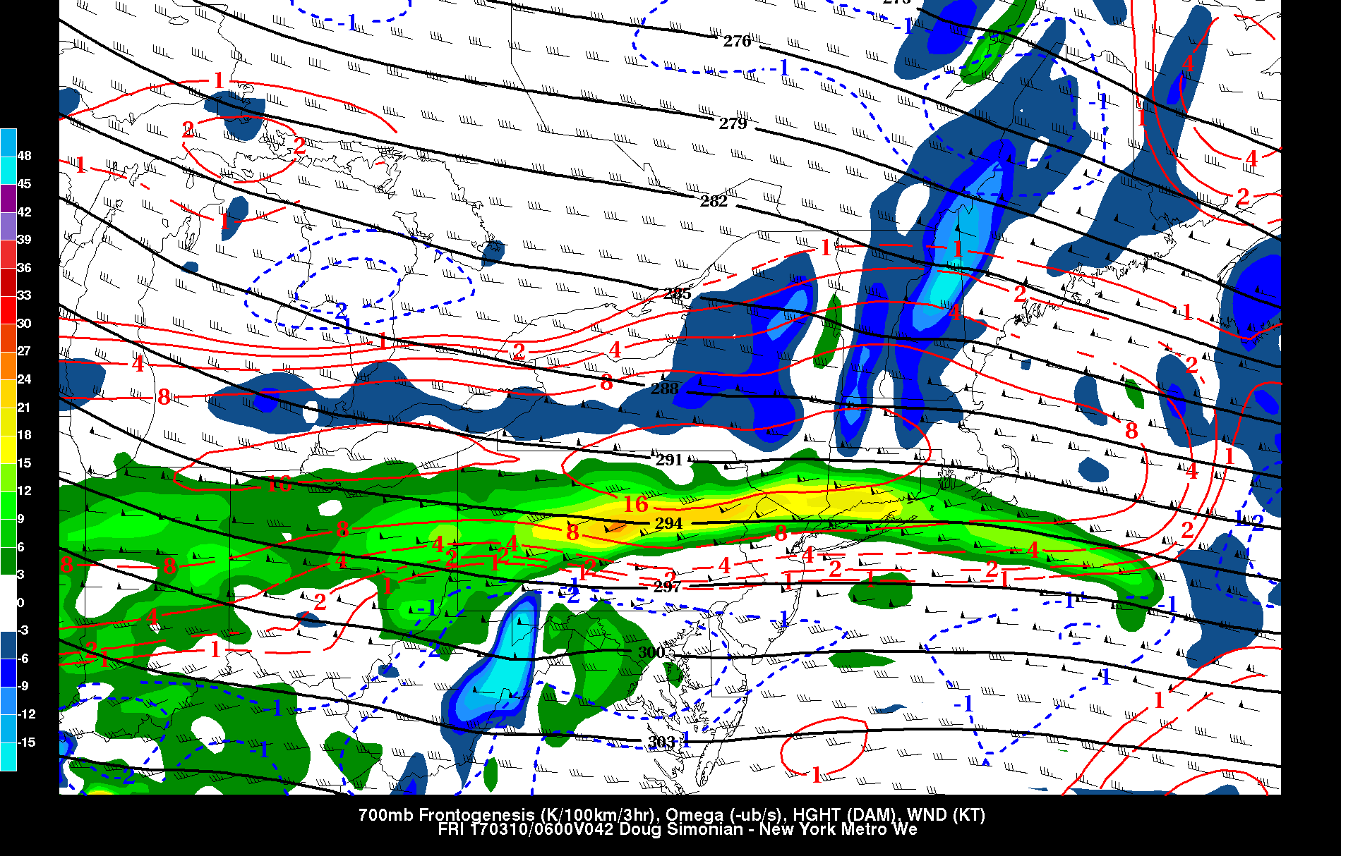
12z NAM showing 700mb frontonegesis and lift with and band of precipitation late Thursday night
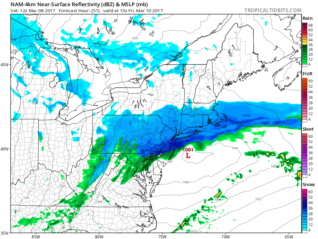
But on Friday, the low be moving just offshore. The region will be sandwiched in between two mid-upper level jet streaks and underneath the 500mb PVA region, where air rises or lifts more rapidly. So the low will begin to slowly deepen and precipitation will expand through the region. Northerly winds will develop with colder air rushing southward — causing a stronger thermal gradient with more mid-level frontogenesis and dynamic cooling. So any rain or wintry mix will likely change over to snow by Friday morning.
Snow may also become moderate and heavy at times Friday morning before tapering off during the afternoon hours, as low pressure moves farther offshore. Snowfall accumulations across the region will depend largely on where heavier banding develops and boundary-layer and surface temperatures for much of the event. If the low tracks further north, some areas south of the track will be warmer and drier initially, which could reduce snowfall totals. We will try to pinpoint these snowfall totals in future updates.
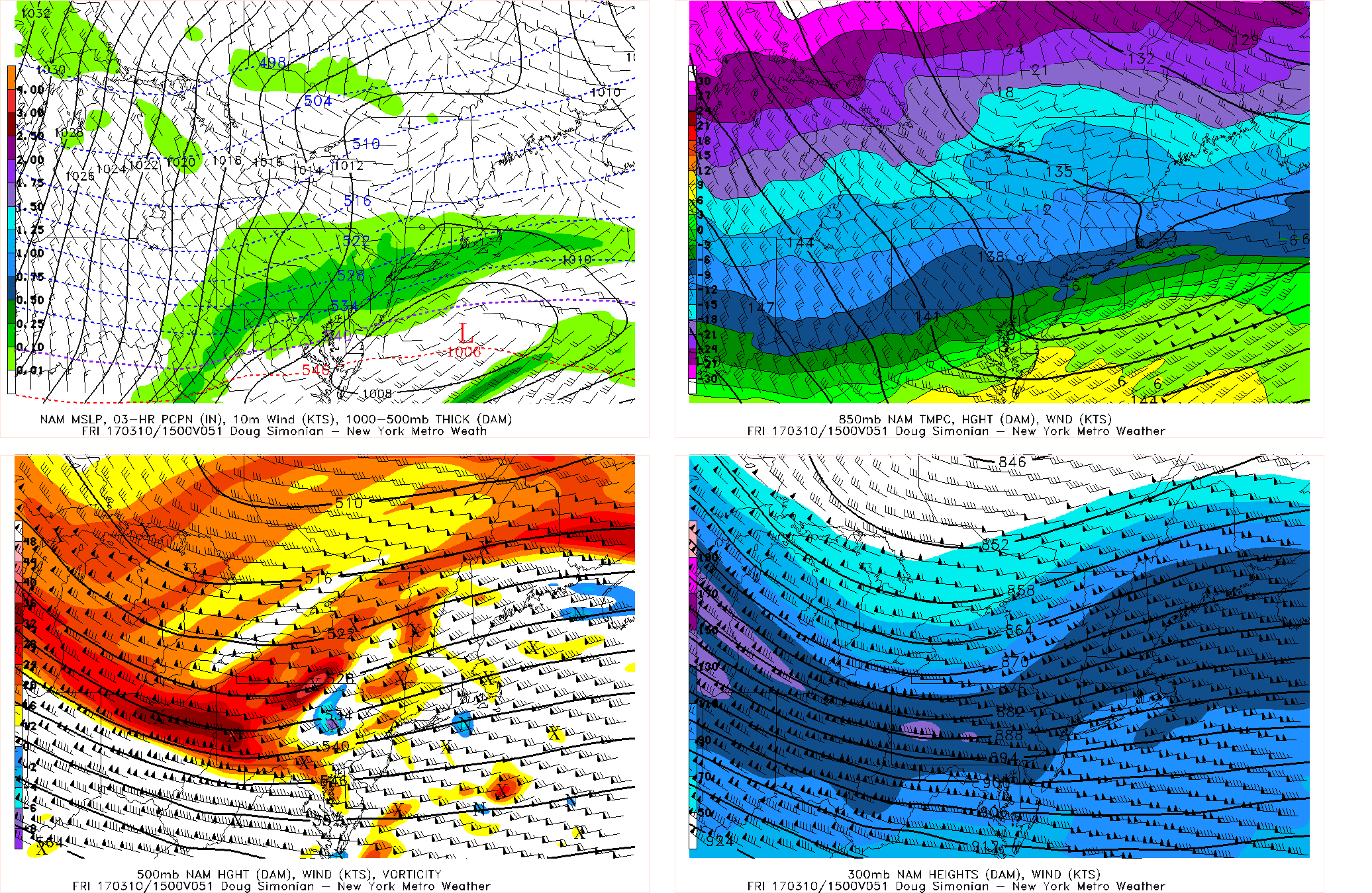
12z NAM showing shortwave energy and between the entrance and ext region of upper-level jet streaks enhancing lift over the region Friday morning .
This weekend will be much colder and drier with the tropospheric polar vortex over Southeast Canada keep another storm system well south of the region. Temperatures will be below normal again with highs in the 30s each day with some sunshine and clouds across the region. Overnight lows starting Friday night will be in teens and lower 20s over much the region. Perhaps some single digits for Interior Valleys by Saturday night.
Early next week a cold airmass will still place as we watch we watch a third storm system, that we’ve been discussing this week, to develop somewhere along the East Coast for Tuesday or Wednesday. With the Greenland block and polar vortex lifting out and strong west coast ridge developing, this system has potential to for northern and southern stream energy to phase into a major Nor’easter, with rain, snow and wind impacts. But we still almost a week away to go into much detail. Stay tuned for zone forecast and other updates as we closer to this system.