Warmth and humidity to return again as anomalous ridge develops

If you were thinking that we had seen the last of warmth and humidity this year, think again. Forecast model guidance is in excellent agreement that a large ridge will develop across the Central and Eastern United States in the next 5 days. This will lead to the development of anomalously warm conditions from the Plains to the East Coast.

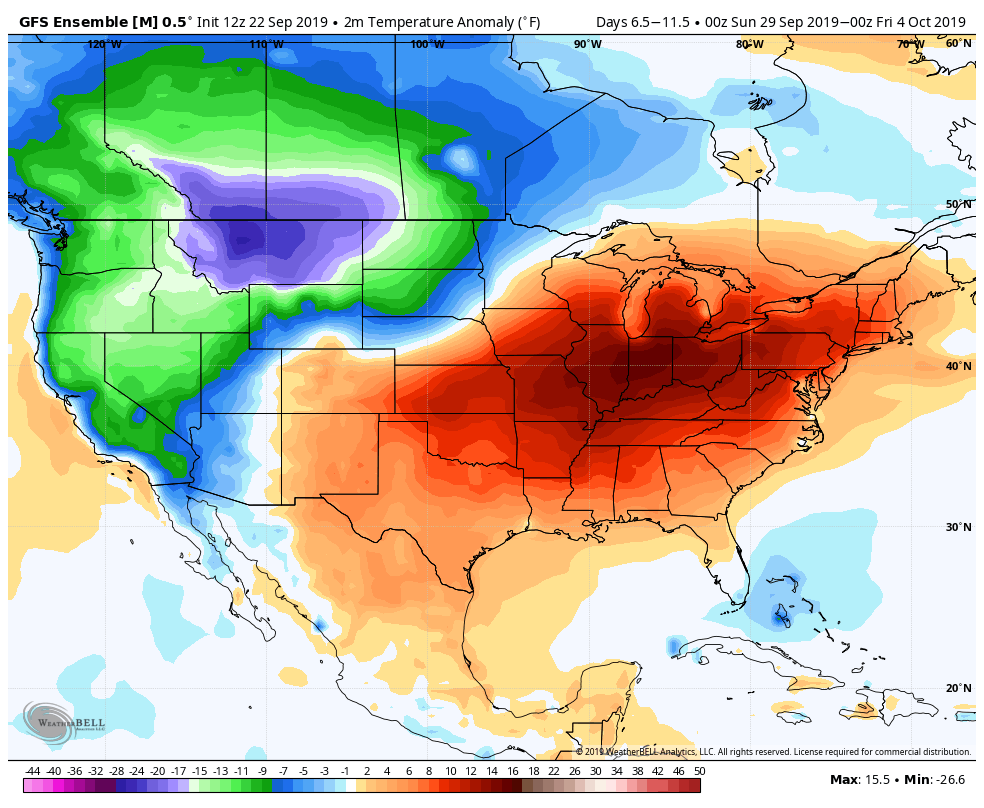
In the Northeast, temperatures could average several degrees above normal for more than a week. At times, forecast model guidance suggests that temperatures could average 15 to 20 degrees above average. Those kind of numbers will lead to unusual – and likely uncomfortable – warmth and humidity.

A summer-like ridge expected to form

Large and sprawling ridges of high pressure have developed across the Central and Eastern United States a few times already this Summer – and multiple times in the past few weeks. This one, though, looks to be particularly strong. Guidance suggests that heights in the mid levels of the atmosphere could approach summer-like levels during the week ahead.

Ensemble guidance continues to suggest that a large ridge will form in the Eastern US over the next several days.

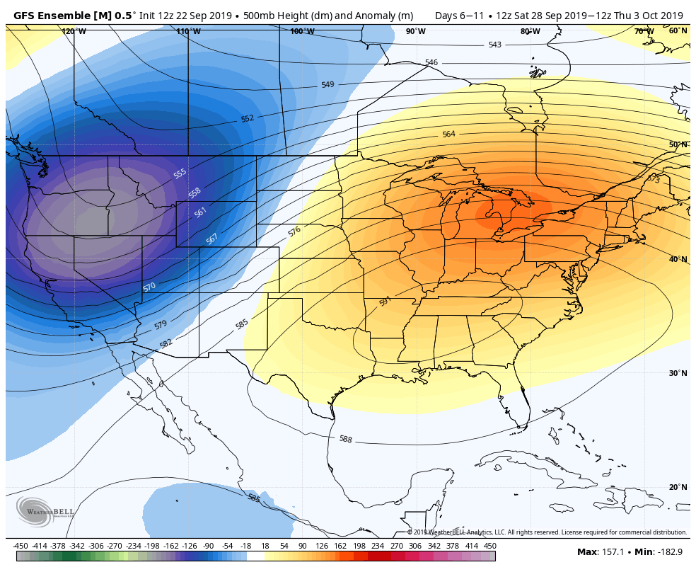
When large ridges of high pressure like this develop, the airmass and air flow can quickly lead to abnormal warmth. Temperatures across the Central United States, particularly from the Plains toward the Ohio Valley, are likely to average 10 or more degrees above normal in the next week.

This warmth will eventually make it into the Eastern United States as well, with temperatures skyrocketing well above normal as we move through the last several days of September. There are some signals that this warmth could continue into the early part of October as well.

Here in New York City, this type of atmospheric pattern almost always means two things: Warmth and humidity. Dew points will gradually rise, and as the airmass around us modifies and the ridge remains in place, temperatures will eventually reach several degrees above normal, too. The forecast during the week ahead is likely to feature temperatures warming into the 80’s by the weeks end.

Temperatures are likely to average several degrees above normal through the end of September.

Tropics expected to remain active

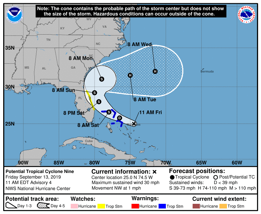
Medium range weather model guidance is also in excellent agreement that conditions will remain favorable for tropical development in the Atlantic over the next 10-14 days. Tropical Storm Karen recently formed and is expected to pass near Puerto Rico before moving northward – but the systems path after that time also remains an uncertainty.

Additional tropical cyclone development is anticipated with clusters of thunderstorms emerging off of Africa in the next week. Multiple systems could develop and begin a general westward movement through the Tropical Atlantic.

Dry, calm weather to continue in NYC as foliage perks up

High pressure will remain in control for the next few days, with calm and dry weather expected. Temperatures will remain cooler and crisp through the end of the week, before warming up this weekend. High temperatures may eventually reach several degrees above normal.

Read more

Prolonged stretch of warm, dry weather expected in NYC

An expansive high pressure system will build over New England beginning today, leading to a prolonged period warm and dry weather in the Northeast. Temperatures are likely to average a few degrees above normal over the next week, with very little threat of substantial precipitation or significant storms.

Read more

Weekend Outlook: Comfortable weather, watching PTC9

Beautiful, lower humidity air has moved into the Northeast this morning in the wake of a frontal boundary. It comes as a great relief after temperatures and humidity skyrocketed to midsummer levels on Thursday. Comfortable air is expected to remain in place through this evening.

Dew points will gradually rise again as we move through Saturday, although the weather will stay mostly pleasant for the majority of the day. As we move into the evening, a storm system will approach the area from the west. Clouds will increase, as will the opportunity for showers and storms.

These are expected to hold off until the evening hours, but will be fairly widespread in coverage when they move through from later Saturday into Sunday morning. Instability will remain quite low, so we aren’t anticipating a severe weather threat. Instead, showers will be capable of producing briefly heavy downpours as they move through.

The weather improves again on Sunday, with low humidity and sunshine returning. Attention will then turn to a period of unsettled weather during the middle part of next week, as well as the potential future of PTC9, which is still located in the Bahamas.

PTC9 still not organized this morning

The NHC declared Potential Tropical Cyclone 9 (PTC9) on Thursday evening, but the system has remained unorganized this morning and is yet to form a coherent center. The official NHC forecast still takes the storm toward the coast of Florida, but then begins to recurve it off the Southeast Coast.

Most reliable model guidance suggests that the storm will strengthen into a Tropical Storm at some point this weekend, but exactly when that occurs remains uncertain. Forecast model guidance is also split in regards to the systems track, and much of that stems back to when exactly the storm organizes.

Latest NHC Forecast for PTC 9

Once the storm moves off the Southeast US coast, it could potentially be blocked from moving seaward by a large high pressure to the north. This will create additional uncertainty as to the storms track and speed, potentially leaving it meandering off the coast for a few days.

Stay tuned for further updates as we move through the weekend – and most importantly, enjoy the day today!