-2")
Warmer air, some clouds on the way for midweek
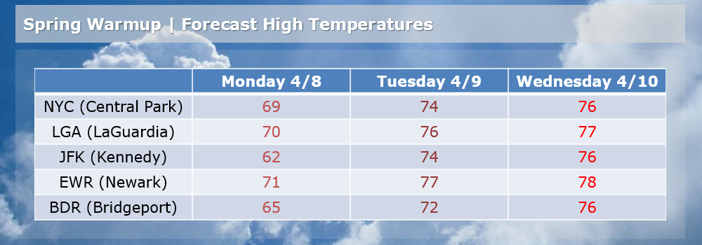
The typical ups and downs of springtime weather have arrived, despite a very slow start with colder than normal temperatures through much of March and the first few days of April. After a big warmup last week, cooler air took over this past weekend with a bout of cold rain and cloudy conditions. However, warmer air is on the way once again as a storm system moves through the Central United States. Tuesday will mark the first “warmer” day of the few, but this one will be slightly more tempered compared to last week with a frontal boundary hanging around the area.

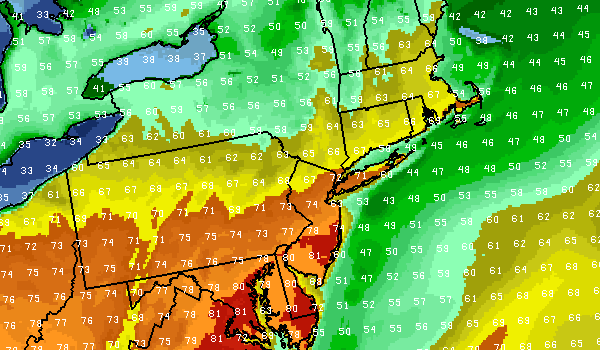
NAM model showing forecast high temperatures throughout the area on Tuesday afternoon. Notice the warmer temperatures, in the 70’s over New Jersey. The southeast winds off the water keep temperatures in the 60’s along the shore.
In addition, a more southeasterly component to the wind will ensure that coastal areas remain at least somewhat cool. Clouds and some fog are expected in the morning on most days this week with the potential for showers as the front nears on both Wednesday and Thursday. In general, however, temperatures will rise into the upper 60’s to lower 70’s especially over New Jersey and working towards New York City. Areas east of New York City and along the shoreline will have more trouble reaching those numbers.
Tuesday: Partly cloudy with highs in the upper 60’s to lower 70’s. A chance of showers. Mostly cloudy and fog early, lasting into afternoon along the shore. Southeast winds around 10 miles per hour. Chance of precipitation is 20%.
Tuesday Night: Mostly cloudy with a chance of showers and thunderstorms. Low in the 50’s. Chance of precipitation is 50%.
Wednesday: Partly cloudy with highs in the upper 60’s to lower 70’s. A slight chance of showers. East-southeast winds around 10 miles per hour. Chance of precipitation is 20%.