-2")
Overview
Briefing
Hot and humid conditions will continue through Tuesday. Chances for showers and t-storms will increase as a cold front approaches on Wednesday. More comfortable warmth and humidity is expected late week.
Forecaster’s Discussion
Last Updated: 9:30am Thursday, July 26th 2019 by MP
Near Term (through tonight)
High pressure will provide mostly sunny skies today. 850mb temperatures around 12-13 C with deep mixing and light northwest downslope winds will support high temperatures closer to normal-in the middle 80s throughout much of the region. Humidity will still be relatively low, which will make for another beautiful mid-summer day.
Tonight, will remain mostly clear with light winds. This will result in more radiation cooling. Low temperatures are likely to in the mid 60s many of suburbs and in upper 60s to near 70 degrees in NYC and urban areas. Some of the far northern Interior valleys will likely drop into the upper 50s to lower 60s.
Hello
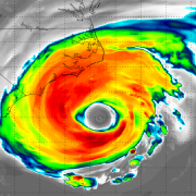
Florence rapidly intensifying, expected to approach Carolinas this week
12:30pm Update: Florence has strengthened into a powerful Category 4 hurricane with maximum sustained winds of 130mph. Additional rapid intensification is expected today, as the upper-level atmospheric environment becomes more favorable over the system. Shear, which has inhibited the systems development thus far, will be greatly reduced, allowing for improved upper-level outflow ventilation as the storm […]

NYC Area Weekly Planner: Heavy Rain & Flooding Concerns to Start the Week
Good morning and Happy Monday! It’s a rough one out there this morning. Showers continue throughout the Northeast and Mid Atlantic, with temperatures in the 50’s and a very damp airmass in place. This weather is generally expected to persist today, but it will be particularly cool this morning. Bring a jacket and an umbrella […]
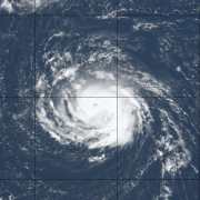
Live Blog: Hurricane Florence set to rapidly strenghten
Over the next 24-48 hours, this page will be continually updated with information on Hurricane Florence. The live blog below serves as a constant feed of information. Check back here for the very latest details as the storm strengthens.