-2")
Overview
Briefing
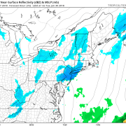
Hot and humid conditions will continue through Tuesday. Chances for showers and t-storms will increase as a cold front approaches on Wednesday. More comfortable warmth and humidity is expected late week.
Forecaster’s Discussion
Last Updated: 9:30am Thursday, July 26th 2019 by MP
Near Term (through tonight)
High pressure will provide mostly sunny skies today. 850mb temperatures around 12-13 C with deep mixing and light northwest downslope winds will support high temperatures closer to normal-in the middle 80s throughout much of the region. Humidity will still be relatively low, which will make for another beautiful mid-summer day.
Tonight, will remain mostly clear with light winds. This will result in more radiation cooling. Low temperatures are likely to in the mid 60s many of suburbs and in upper 60s to near 70 degrees in NYC and urban areas. Some of the far northern Interior valleys will likely drop into the upper 50s to lower 60s.
Hello
Saturday AM Briefing: Showers Tonight, Northeast Snow Threats Next Week
Good morning! High pressure will provide mostly sunny skies today. Temperatures started out below freezing this morning outside of the major cities, mostly due radiational cooling overnight. This also resulted in some black ice forming on roadways. However, a strong upper-level ridge and southwest flow will lead to some unseasonably warm temperatures by this afternoon, […]
Brief Warm-up This Weekend, Colder and Potential for Some Snow Early Next Week
Good evening! Today has been another cold, but seasonable day across the entire Northeast as an area of high pressure continues to push off the Mid Atlantic coast this afternoon. Mid level heights have been rising over much of the East coast ahead of a large, but a disorganized mass of energy moving through the […]
Friday AM Briefing: Changeable weather in the East, wintry threat next week?
Good morning, and Happy Friday! Finally. Cold and dry weather built back into the Northeast states on Thursday, and temperatures dropped near or below normal in many locations thanks to a transitional trough moving through Southeastern Canada. Such has been the nature of this pattern over the past week or two – relatively fast moving, […]