-2")
Severe weather potential could highlight Saturday
Although the northeast has not seen too much in the way of severe weather in the past couple of weeks, that may change come Saturday, as the potential exists for a severe squall line with damaging winds, and perhaps even a few embedded tornadoes.
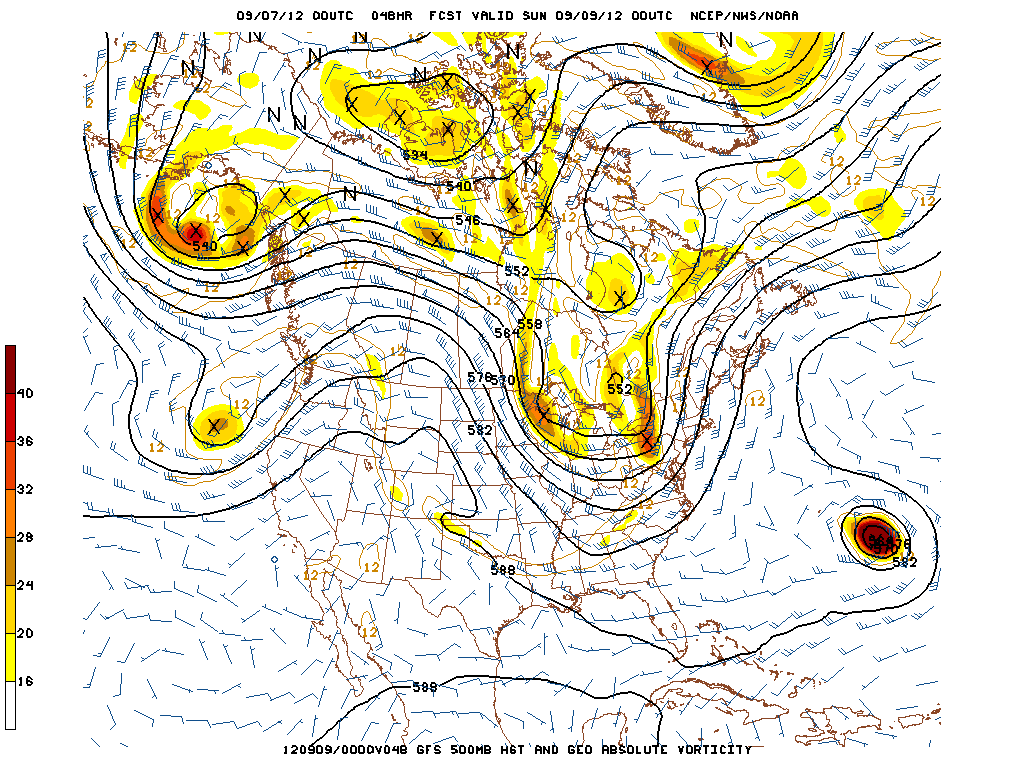
00z GFS 500mb Forecast, Valid for 00z Sunday, September 9th, or 8pm EDT Saturday, September 8th.
We have an extremely potent longwave trough, which will advect unseasonably strong mid and upper level winds; something that we have not seen in quite a while. In most of the setups we have seen this summer, the 500mb winds were quite slow, mostly 30 knots or below, which was often a hindrance for widespread organized convection. But now that we have reached September, the jet stream starts to become a bit stronger, and troughs begin to amplify more and dig to the south.
More specifically at 500mb, we also have quite a potent area of vorticity in Pennsylvania, which combined with the longwave trough, will provide a good lifting mechanism for large-scale ascent. Additionally, the 500mb winds are in excess of 50 knots, which is quite sufficient for organized convection. Click “Read More” below to read the full length post.
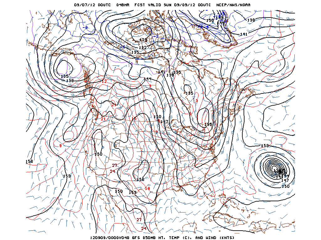
00z GFS 850mb Forecast, Valid for 00z Sunday, September 9th, or 8pm EDT Saturday, September 8th.
Additionally, at 850mb, we see a very potent closed low in Southern Canada. This helps to create a strong low-level jet, with 850mb winds well in excess of 30 knots. For tornadic activity in the Metro region, 850mb closed lows are generally a tad further south. However, this low is so potent with this powerful trough that it has essentially the same effects as a slightly weaker 850mb low in an “ideal” position would. With all that said, this would still seem to favor the best low-level rotation in areas north of the immediate Metro area. Also note the parallel isotherms in a N/S orientation, indicating a pretty strong cold front.

00z NAM Surface Forecast, Valid for 00z Sunday, September 9th, or 8pm EDT Saturday, September 8th.
Going down to the surface, we can see that the 00z NAM is forecasting an unseasonably deep surface low, around 990mb! This will also help with lift out ahead of it, and with its cyclonic flow, a decently strong SE flow will be generated. The general rule is that deeper surface lows will have better lift, which considering the fact that instability won’t be off the charts, is a good thing if you want severe weather. However, a potential caveat to this will be addressed later.
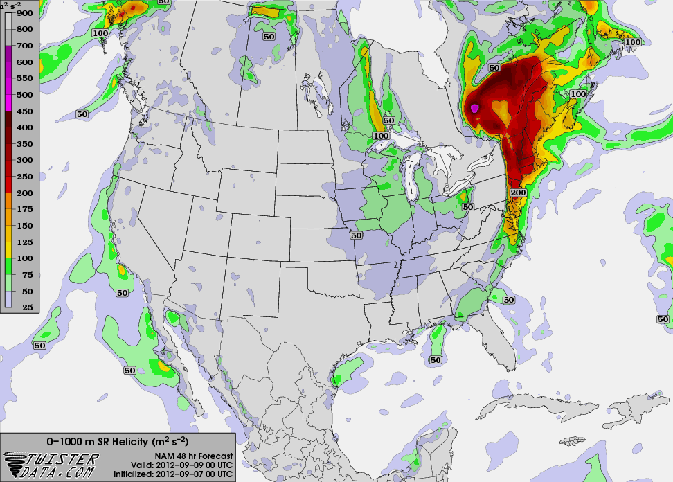
00z NAM 0-1km Helicity Forecast, Valid for 00z Sunday, September 9th, or 8pm EDT Saturday, September 8th.
Now it’s time to go down to the mesoscale. Because of the SE winds forecast to be around 15 knots or so, and 850mb winds well in excess of 30 knots, and even approaching 50 knots in some locations, lots of low-level shear and helicity will be generated. The 00z NAM at 48 hours shows 0-1km helicity values in excess of 200 meters squared per second squared, which is sufficient for mesocyclones and even tornadoes.
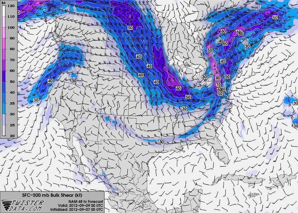
00z NAM 0-6km Bulk Shear Forecast, Valid for 00z Sunday, September 9th, or 8pm EDT Saturday, September 8th.
Because of the aforementioned strong 500mb winds, our 0-6km bulk shear values also look to be quite high, which is something we have not seen much in the way of over the past month or so. The strong shear going all the way up to 6km will help generate organized storms with taller vertical structures. It will also greatly help with updraft and downdraft separation, which can induce long-tracked squall lines, as a storm would maintain its health for quite a while.
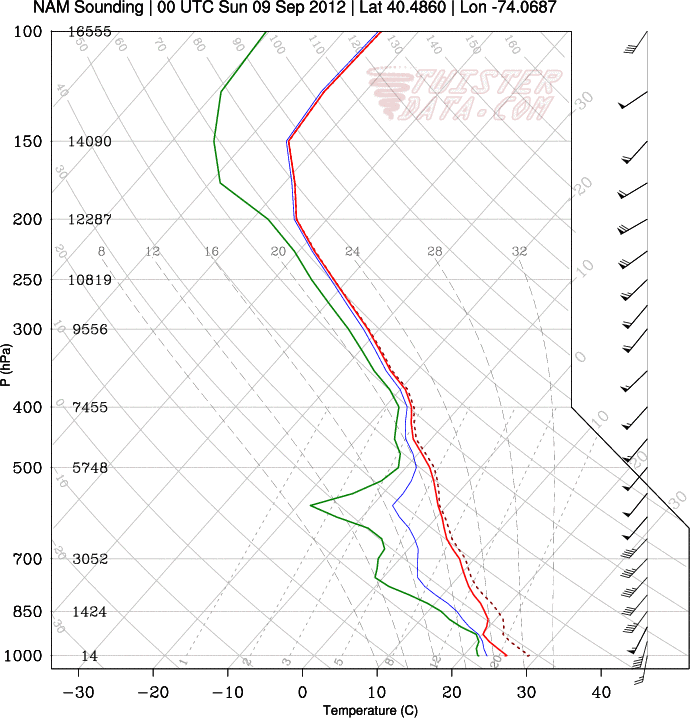
00z NAM Point-and-Click Forecast Sounding for the KEWR Area, Valid for 00z Sunday, September 9th, or 8pm EDT Saturday, September 8th.
Now, let’s take a look at the soundings. The next image is a point-and-click sounding from the KEWR (Newark International Airport) area, valid 8pm, Saturday night. Note how quickly the winds increase from the surface to 925mb – the winds at 925mb are 55 knots! That alone, even without a strong thunderstorm can induce very gusty winds if any convection can mix that down to the surface. Additionally, this leads to lots of low-level shear; the 0-1km bulk shear is 33 knots at this time. Although the directional shear is not stellar, it is still prominent enough for potential spin-ups.
When looking from 850mb to 500mb, notice how for the most part, the speed and directional shear is nearly negligible. However, the winds are still quite strong, as they are 50 knots at 500mb and well above 50 knots as you go above 500mb. This leads me to believe that any spin-ups and mesocyclones will generally be in the low-levels. The strong winds throughout the profile leading to the favorable 0-6km bulk shear will help to form an organized squall line, as although there is localized directional shear in the low-levels, as a whole, most of the shear is speed shear. This will help to move the squall-line from west to east quite quickly, and when combining that with the strong low-level jet, the threat for damaging winds is quite high.
Also note that there is moisture in the low-levels of the atmosphere, helping to provide instability, which is important considering the mid-level lapse rates are not stellar, although low-level lapse rates are okay. There is also a nice pocket of dry air in the mid-levels of the atmosphere, which promotes evaporative cooling, as it lowers the wet-bulb temperature (blue line). If precipitation is significantly cooling off the surrounding environment, air parcels can become more negatively buoyant, meaning that they are more likely to rapidly sink, favoring strong downdrafts and straight-line winds. In addition, this would favor colder temperatures for longer lasting hail. However, the poor mid-level lapse rates lead me to believe that hail will not be a major threat, as vertical cloud growth will not suffice in leading to high enough cloud tops that are cold enough for large ice crystals and hail to form.
Additionally, any locally backed surface winds, particularly in the Hudson Valley, will help turn the surface winds to the SE, creating even more low-level wind shear and helicity. This is most prevalent as you head towards Albany, as cyclonic flow from the surface low will more readily turn to the SE as you head further north. Also, valleys tend to “trap” southerly winds, as opposed to southwesterly winds.
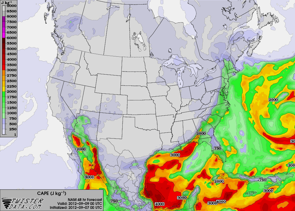
00z NAM CAPE Forecast, Valid for 00z Sunday, September 9th, or 8pm EDT Saturday, September 8th.
Now, what can go wrong? For one thing, there is a timing concern. The NAM and GFS have been going back and forth on the timing of the cold front. If the cold front is too slow, then the convection would arrive well after the instability wanes, and considering we are not working with a whole lot of instability to begin with, that could be problematic for maintaining a strong squall line. Here is the NAM forecast CAPE for 8pm on Saturday night.
That being said, because of the potential timing concerns, I think the best of the severe weather potential will be to the north of the Metro area, and western areas as well. But that detail can change. Either way, the potential is there for an organized squall line with damaging winds with some embedded low-level mesocyclones and tornadoes, even in the immediate Metro area.
Trackbacks & Pingbacks
[…] New Jersey, New York City and the coastal Northeast. For more on the threat, you can check out our event overview post from this morning , but be sure to also follow us on Twitter and Facebook for the latest real-time updates as we draw […]
Leave a Reply
Want to join the discussion?Feel free to contribute!