-2")
Weekend winter storm likely to bring various impacts
A developing mid and upper level disturbance over the Central United States will slide eastward towards the Ohio Valley, and then redevelop off the Mid-Atlantic coast this weekend, providing a myriad of winter weather threats in our area When combined with the deep cold arctic air entrenched in the area upon its arrival, the storm seems likely to produce a fairly significant amount of snow and ice, especially away from the coast. But warmer air moving in aloft, and eventually at the surface, presents a forecast headache — as precipitation type will be difficult to predict until the event draws nearer.
Forecast model at this range are beginning to come into better agreement on the eventual track of the surface low associated with the mid and upper level disturbance. The initial (or primary) surface low seems likely to be driven from the Mississippi Valley into the Northern Mid Atlantic or Ohio Valley. But cold air, reinforced to the north, and associated with a strong high pressure system, and compressing heights aloft will force the storm to redevelop to the south and east off the Mid Atlantic coast before eventually scooting northeastward out to sea.

Canadian GGEM model showing the low pressure system off the Mid Atlantic coast with precipitation in our area, and a sharp gradient from snow to sleet and rain.
The origin and track of the storm system, however, provide the opportunity for a myriad of threats — and wildly varying results throughout the forecast area. Of first concern is the anticipated push of WAA (Warm Air Advection) which will occur as a result of the primary surface low tracking to our north and west. This track will allow the mid level low’s to move into the Ohio Valley, and a thin warm layer will develop between 850-900mb (still the low levels of the atmosphere, but well above our heads). The southerly winds at these levels will warm the temperatures there, while cold air remains entrenched at the surface. This raises concern for a period of sleet or freezing rain.
This is especially true over the interior, as the coast will experience warming surface temperatures owing to southeast winds off the warmer area waters. Inland, this has much less of an affect. So while the temperatures aloft may warm, the surface remains quite cold — raising concern for a frozen precipitation event that may produce not only snow, but sleet and ice, which could cause more hazards.
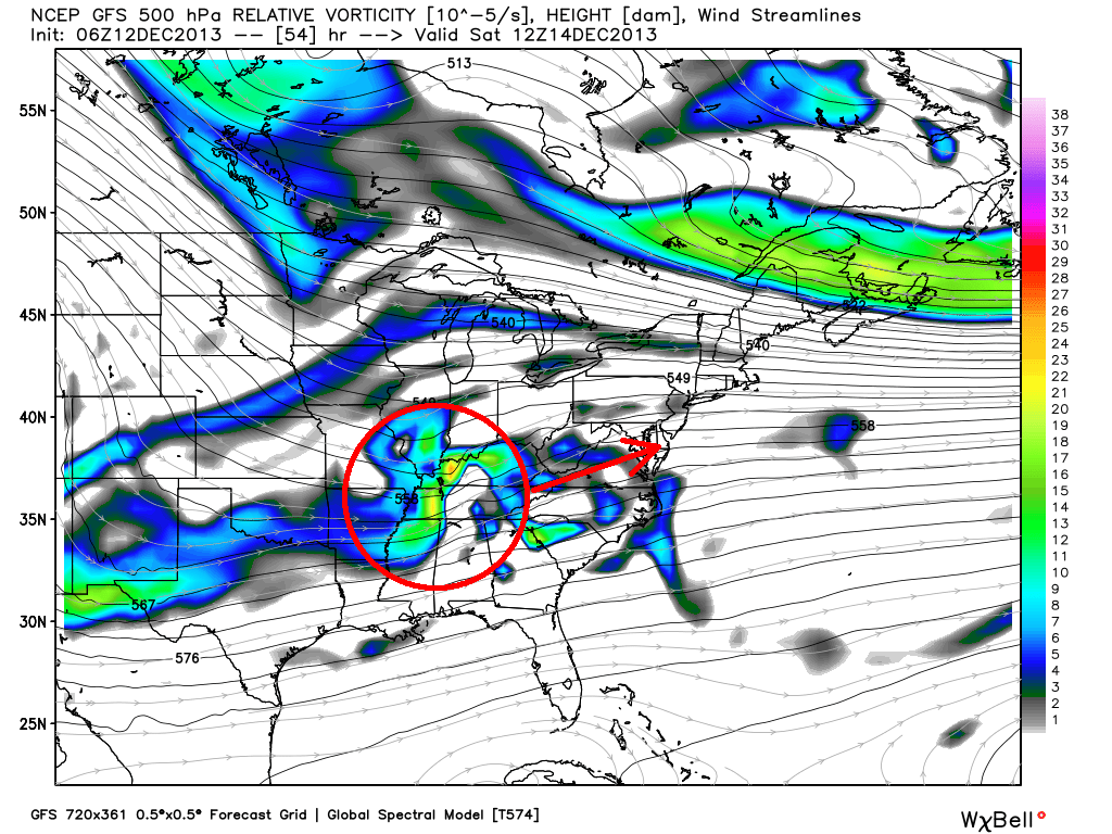
GFS model showing the mid level disturbance (image shows 500mb height and energy) moving from the MS Valley to the Mid Atlantic states. Image courtesy Wxbell.
What are the expected hazards and travel impacts?
Travel impacts will likely be high for a period of time on Saturday night, as moderate to heavy snow picks up over the interior and city for a period of time. These travel impacts will begin to lighten near the coast with time overnight on Saturday as precipitation transitions to rain. But west of the city, travel will become even more hazardous on Saturday overnight into Sunday as sleet and freezing rain create a very icy situation.
Hazards of snow and ice will continue through Sunday across these areas. Generally, the greatest hazards are expected over Northern 1/3 of NJ, NYC for a period of time before a transition to rain, Southeast New York and Connecticut. The ice and freezing rain could become especially prevalent over Interior NJ and Southeast NY.
What is the expected timing of the storm?
Snow is expected to begin throughout the area, starting from southwest to northeast, on Saturday afternoon and evening. The snow should slowly expand and intensify during the evening hours on Saturday and begin to accumulate throughout much of New Jersey and New York, while spreading into Connecticut. By later Saturday evening, snow will begin to transition to sleet and rain across Southern New Jersey and East/Southeastern Long Island. This line of transitioning precipitation types will slowly work northwestward towards Central New Jersey and New York City during the overnight hours.

NAM model showing the low pressure offshore on Saturday night, with a tremendous temperature gradient in the NYC Area.
By early morning on Sunday, much of Southern and Central New Jersey, Long Island and Coastal Connecticut will have transitioned to rain. Interior New Jersey and New York City will likely be transitioning to freezing rain, sleet or rain as well. The progression of this transition will slow a bit as it heads northward, and freezing rain/icing is expected to continue across interior New Jersey and Southeast New York.
Precipitation will taper off (probably as freezing drizzle) throughout the area later on Sunday morning with clearing possible by the afternoon.
What are the remaining uncertainties?
Despite increasing confidence in the event, there remains quite a bit of uncertainty in regard to several aspects of the storm system. First, the exact track of the system will be critical to many other aspects of the system. So while forecast models are starting to come into better agreement on the system, slight waffles in the forecast track keep our confidence fairly low. Second, precipitation type — owing to temperatures and atmospheric profiles before and during the event. In situations like this one, where a few degrees can make a world of difference as far as sleet, snow, and freezing rain are concerned — confidence will remain very low. In this regard, confidence will not be high until the day of the event as we track mesoscale developments in temperature.
Wrapup and first snowfall forecast
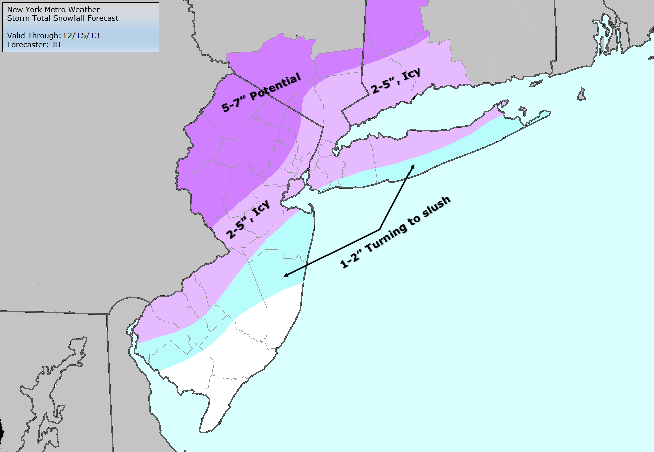
Storm Total Snowfall Forecast from Saturday through Sunday.
Our forecasters have pushed out a Storm Total Snowfall map for the weekend winter storm system, but we have a few important notes before you rip and read the map. First of all, this map is a preliminary forecast — and the amounts are general. This is not to say that we have low confidence in our own forecast, but only a reminder that the forecast may change before the event approaches. Secondly, it is important to note that this forecast does not include freezing rain or icing, which as noted above, could severely compound problems.
Over the next few days, expect more detailed posts and forecasts as we continue to gather information on the upcoming storm system. Stay tuned to our social media network accounts for updates throughout the upcoming days.
Leave a Reply
Want to join the discussion?Feel free to contribute!