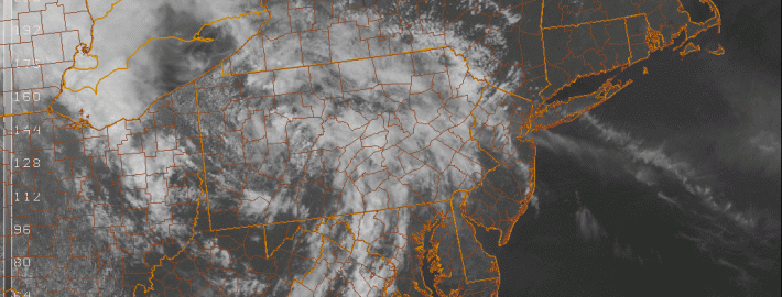
Warm, but unsettled weather this week

Often, meteorologists pay close attention to the progression of the pattern very early in the Spring season. Although not backed by any statical research, it is often found that the patterns and trends in regards to frontal boundaries and airmass progression early in the Spring season can foreshadow how those very same boundaries will behave later in the season. This year has been no exception.

Early this Spring, warm fronts struggled to move northward from the Mid Atlantic, yielding instead to the cooler ocean waters and troughiness to our north and east. This very same thing occurred this past weekend, as warm front struggled northward from the Washington, DC area. Additionally, backdoor cold fronts have had plenty of push towards our area from New England — with marine air overtaking the pattern. This very same thing will occur on Tuesday, temporarily pushing out the warm airmass in place on Monday.

Read more

El Nino Update: Not a matter of if, but how strong

As the Spring season moves along, signs begin to become more clear regarding the development of an El Nino. Although there has been relatively high confidence in the development of an El Nino for quite some time, there was still a small bit of doubt, as some expressed skepticism. However, over the last month or so, the atmosphere has undergone changes which should remove any seeds of doubt regarding whether an El Nino will be developing this Spring and Summer. The only doubts that exist now is the final strength of the event (El Nino events usually peak in the Autumn): high-end moderate/low-end strong, a strong event, or a super strong event. For more information regarding the formation of El Ninos and what they mean for our weather pattern, check out the article we published last month. 

What has happened that makes us so confident? The easterly trade winds which usually keep warm water well to the west towards Indonesia have shifted to westerlies. 

This animation shows the progression of the strength and direction of wind currents. Note how they started off blowing from east to west, but have dramatically shifted in the opposite direction. This is a strong indicator that an El Nino is coming. Click to animate.

This animation shows the progression of the strength and direction of wind currents. Note how they started off blowing from east to west (easterlies, blue arrows), but have dramatically shifted in the opposite direction (westerlies, red arrows). This is a strong indicator that an El Nino is coming. Click to animate.

This means that the base state of the atmosphere which prevents El Nino events has completely changed to one that favors El Nino events. The typical climate pattern has easterly trade winds along the Equator, which blow warm water along the Equatorial Pacific to the west, towards Indonesia and Australia, leaving the rest of the Equatorial Pacific relatively chillier. Now that the surface currents have shifted to blowing from west to east, it becomes much easier for that same warm water from the west to move eastward throughout the rest of the Equatorial Pacific, leading to an El Nino.

Read more