-2")
Despite cold weekend, November looks to start off warm
As many of you have probably heard by now, a major shot of cold air is on the way for this weekend, with the potential for a storm system to bring the first snowflakes of the season for some areas. For more information on that threat, check out our article we published earlier this afternoon. This article will focus on what’s to come after that blast of cold air.
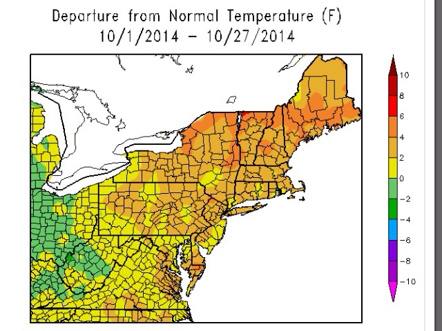
October is just about complete, and it was a very warm month both nationally and regionally.
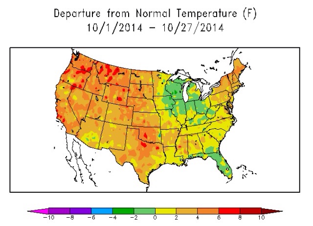
It has been much warmer than average for most of the country this month (ACIS).
In predicting the future weather patterns, we often like to take a look at what has happened in the recent past, and roll forward with any expected changes to the pattern, or lack-there-of. Here is the 500mb pattern that has occurred in the Northern Hemisphere this month:
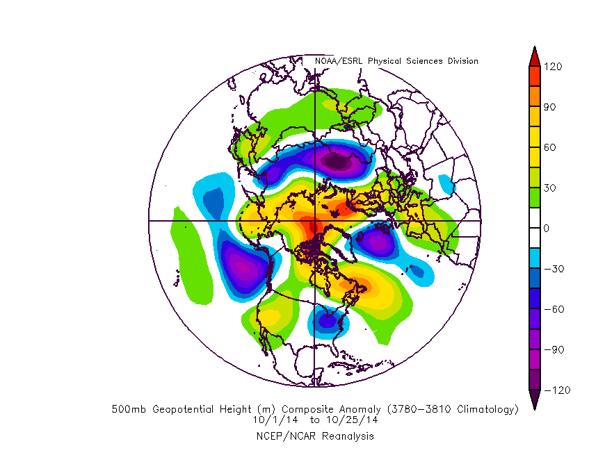
The 500mb pattern this October featured a large trough in the NE Pacific, which largely prevented Arctic intrusions.
The two big features that stand out are the large amount of blocking near the North Pole — particularly the Eurasian side of the Pole, and the large trough in the NE Pacific. The blocking supported a large amount of snow in Eurasia, as the snow cover this year in those regions is among the highest it’s ever been in October. This doesn’t affect our current weather pattern this month so much, but it does lead to the higher probability of a snowy winter.
The trough in the NE Pacific tends to bottle up Arctic air in Alaska, as there is no true mechanism to force it towards southern Canada and the United States. Last winter, we had constant strong ridging in that same location, which allowed Arctic air to slide down the east side of the ridge into the United States. With a constant trough in the NE Pacific, the airmasses that move downstream tend to be Pacific-contaminated, as opposed to Arctic in origin. Thus, despite the strong ridge in the western half of the country, and the trough in the east, most of the eastern half of the country was still very warm this month — the troughs did not necessarily carry an abundance of cold air, nor were they very strong in the means. Only in the absolute core of the trough — the Great Lakes — was there any anomalously cool air this month.
The big question is whether this pattern looks to change anytime soon. While we do expect some subtle changes, the overall large-scale features will tend to be the same moving forward towards the first half of November.
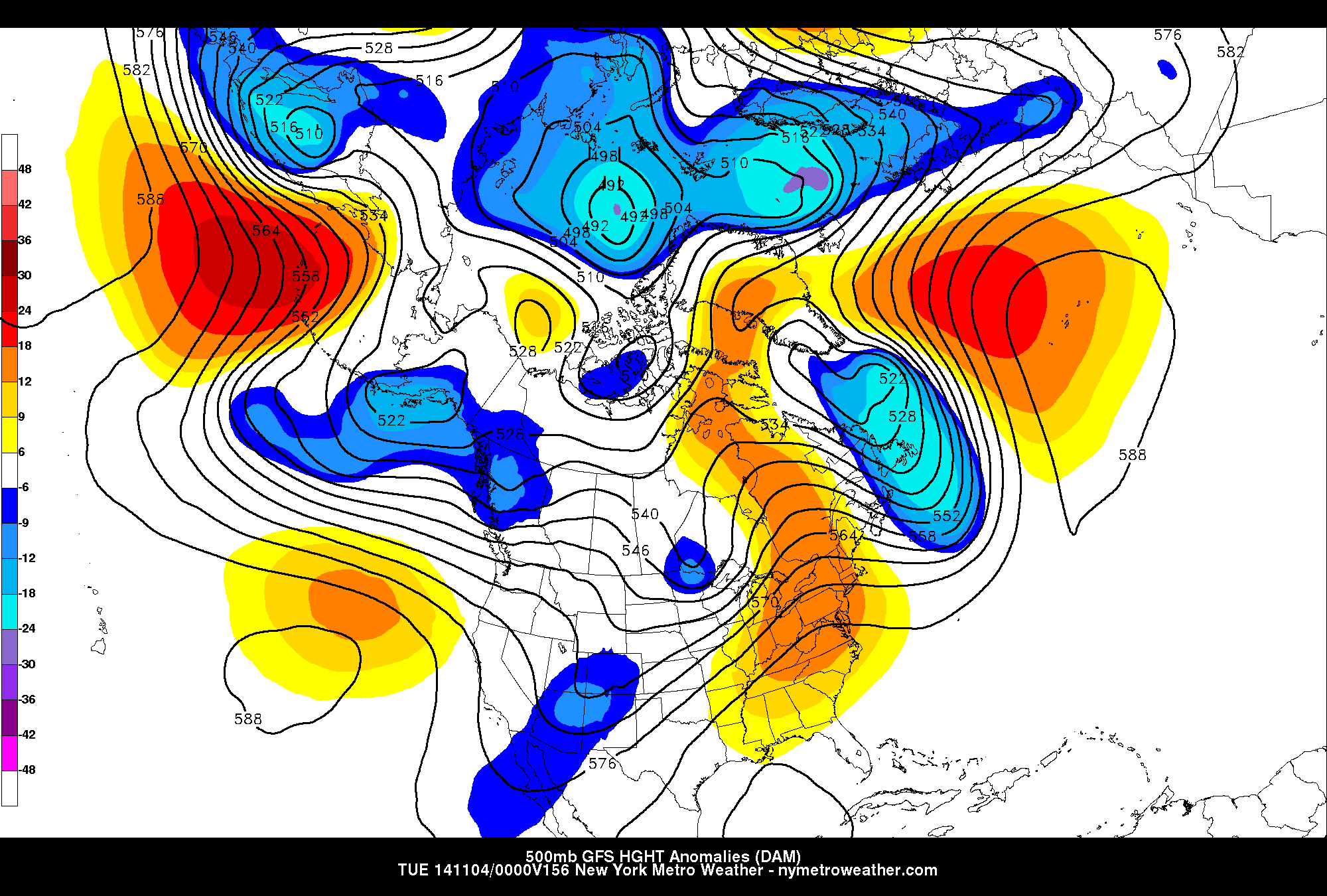
The 500mb pattern from this morning’s GFS valid for next week still shows some troughing in the NE Pacific and no mechanism to draw sustained Arctic air southward.
Despite cold air moving in this weekend, we do not have a strong blocking at our side of the Poles — only some temporary, transient block that may act to help fuel the storm itself. This means that once the storm moves out, so does the cold air — the features of the weather pattern very freely can move from west-to-east. Thus, a strong ridge will be moving in to start the month, as seen in the above image.
What further augments these features is the fact that the NE Pacific pattern is still not favorable for sustained cold air. Just like in this October’s composite, troughing is still seen in the NE Pacific, allowing Pacific air to move into the US, instead of Arctic air. Additionally, there is even a bit of a ridge developing to the south of that trough — off the coast of Oregon and California. Since the ridge is very close to the trough, it creates a strong gradient in 500mb heights — notice how close together the height lines are in the Pacific, and how they are aligned in a west-to-east fashion. This further helps to “shove” Pacific air into the US, continues the constant west-to-east movement of weather patterns, and doesn’t allow too much cold air to dive southward. We generally call this a zonal weather pattern.
What this results in is that even after our ridge to begin next week leaves, it will not be replaced by sustained cold air. Yes, there may be a cold front with periods of rain and then a brief bout of chilly temperatures, but it will quickly be replaced by warmer temperatures. There is also no sign of blocking developing near Greenland, which would try to slow down any zonal weather pattern.
Another reason for increased confidence in this forecast that the weather pattern is aligning with what we would typically expect given other atmospheric conditions. Currently, a weak El Nino continues to slowly develop, and although there is much more to the atmosphere than El Nino, a composite of El Nino Novembers does show some similarities to what is being modeled, just a bit displaced to the west.
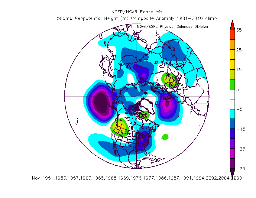
500mb composite of El Nino Novembers. Very strong El Nino events such as 1997 and 1982 were eliminated due to being far beyond what is occurring now.
El Nino Novembers have a strong tendency to have strong troughing near the Aleutian Islands — the western part of the Gulf of Alaska. The troughing that we have is a bit further east, but still a byproduct of that same feature. That trough being further east compared to the composite also makes sense given the zonal weather pattern that is about to occur — so if one were to make a “zonal” version of an El Nino November composite, that Aleutian trough would intuitively have to shift to the east, as zonal weather patterns move quickly from west-to-east. And that leads to the pattern that is being forecast for the first half of November.
This means the ridging in the west would shift to the Northern Plains but be weaker, the immediate west coast will have chilly, raw, and wet conditions, and the eastern half of the country would often receive the warmth spreading from the Plains. Thus, despite November 1-2 being quite cold, the November 3-15 period should, as a whole, feature well-above average temperatures for our area.
Moving forward to the 2nd half of November, there is a bit more uncertainty. History of El Ninos says that the NE Pacific troughing should retrograde to the west towards the Aleutians, which would favor ridging moving back further west, and a bit more troughing in the east. That being said, the NE Pacific/Gulf of Alaska trough can sometimes be a staple feature that takes a long time to move west, and may take an even longer time to truly adjust the weather pattern back to sustained cold. This means that as of now, the 2nd half of November may cool off closer to average — with a warm start and a cooler finish — and December is still an unknown. Fortunately, our winter forecast will be released soon, and we’ll have a much better picture as to what will happen in December.
Leave a Reply
Want to join the discussion?Feel free to contribute!