Showers & storms possible through Wednesday
Summer-like weather settled into the area this Memorial Day weekend, with temperatures soaring above the 90 F mark in several locations on

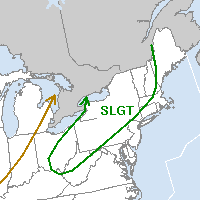
Storm Prediction Center's Day 1 Outlook showing a "Slight Risk" for severe thunderstorms to our west/northwest over the interior Northeast.
Monday afternoon. A large ridge in the mid levels of the atmosphere was the culprit for the hot weather. Thus far, our area has avoided a widespread threat of showers and thunderstorms, although some areas did receive copious amounts of rain in the isolated storms over the past few days. The coverage of these storms, however, has been low. As Memorial Day weekend becomes a memory, a cold front will approach the area on Tuesday…setting the stage for the entrance of more unsettled weather. Showers and thunderstorms could impact the area by afternoon — but again, the coverage of the event remains in question. Forecast models have been too aggressive in showing thunderstorms so far this weekend, so we’re approaching this event with some caution. But it seems like a good bet that, at the very least, some showers will move through the area as the weak pre-frontal trough sweeps through.
The actual surface cold front won’t move through until early-afternoon on Wednesday (maybe a few hours earlier, depending on the speed of the front) — so we could potentially see scattered showers and storms until then. The Storm Prediction Center placed a good portion of the Northeast US in a Slight Risk for Tuesday — but this does not include the New York City area. The shear usually required for organized severe thunderstorms is once again lacking — supporting the idea that the storms will not pose a threat for organized severe weather. However, it will still be warm ahead of the front on Tuesday. Forecast models are indicative of temperatures approaching the 90 F mark once again in some locations (the mid-upper 80’s for sure) before the showers and storms enter the picture.
Stay tuned for updates on the potential showers and storms, as well as updates on any isolated strong thunderstorm threats..including the relay of watches and warnings from the Storm Prediction Center and local National Weather Service.

Excellent blog here! Also your site loads up fast! What web host are you using? Can I get your affiliate link to your host? I wish my web site loaded up as quickly as yours lol
Hey this is kind of of off topic but I was wondering if blogs use WYSIWYG editors or if you have to manually code with HTML. I’m starting a blog soon but have no coding skills so I wanted to get guidance from someone with experience. Any help would be greatly appreciated!
At this time it sounds like Drupal is the preferred blogging platform out there right now. (from what I’ve read) Is that what you’re using on your blog?