2012 Transit of Venus: Astronomical event of a lifetime

An incredibly rare astronomical event, known as the Transit of Venus, occurs later this afternoon as Venus passes over the evening sun (at least here
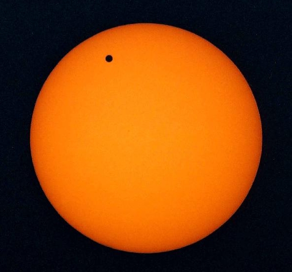
The Transit of Venus across the sun involves the gaseous planet passing between our orbit and that of the suns. The event won't occur again for 105 years. (NRAO)

on the East Coast of the United States). The event last occurred in 2004 and, get this, won’t occur again until 2114. This is, literally, the chance of a lifetime for astronomers and space enthusiasts alike to witness an incredible event. The event occurs as Venus, a gas planet lying between the Earth and the Sun’s orbit, passes directly over the sun. With the right tools, anybody on Earth can observe it as a small black dot, progressing over the suns light. If you plan on viewing the event, however, experts suggest that you wear solar eyeglasses or dark, polarized lenses for safety and better viewing. It will  be nearly impossible to view the event by looking directly at the sun with the naked eye — and you can actually hurt your eyes fairly severely by doing so.

The forecast, however, is less enthusiastic about the once in a lifetime event. Forecast models are indicating the potential for clouds across almost the entire area (70% chance of clouds across some areas, to as low as 40% across others). Such a forecast, more often than not, means the event won’t be viewable. That being said, if you happen to be lucky enough to grab some clear skies and sun this evening, the transit occurs at 6:04pm EST. So get your specialized glasses ready!

Looking to view the event in NYC? Various sources report that astronomy specialists and enthusiast groups have set up viewing sites around New York City, including areas near Riverside Park, Union Square, the High line, and 125 Street in Harlem.  Stay tuned to our Twitter account for more updates throughout the day on the cloud situation.

May 2012 Recap: Wetter, but still above normal

The streak continues: May 2012 was unable to break the streak of over 13 straight months which have finished above normal in the temperature

Temperature departures from normal in the United States during the month of May 2012 (HPRCC)

department in New York City. Such a streak is not unprecedented, but is becoming very impressive with each month that passes. The last month which registered a below normal departure from average was March of 2011, which seems like a distant memory at this point. The more you analyze the statistics, the more impressive they become. Every single month beginning with April 2011 has been above normal in NYC — including the Summer and Autumn of 2011, and Winter and Spring of 2012. May 2012 featured several rainy days, and several days with bel0w-normal departures, but a late-month surge of heat was enough to keep departures above normal. Still, since May 1st 2012, 24 of 35 days have featured rain (measurable precipitation in New York City). To have such a high amount of days with precipitation, but still average temperatures 2 to 4 degrees above normal is pretty remarkable. That being said, the month finished above normal in the temperature department across much of the Central and Eastern United States, stretching from the Northeast through the Great Lakes and Plains into the Desert Southwest. The above-normal departures certainly were not localized to our area.

The May 2012 Stats for NYC (Central Park)…

Temperature departure from normal: +2.7

Highest observed temperature: 89 (5/28, 5/29)

Lowest observed temperature: 49 (5/11)

Total rainfall: 5.38″ (+1.19″ departure from normal)

Frequently occurring unsettled weather (# of days with occurrence): Fog (20), Light Rain (18), Haze (10), Rain (8), Heavy Rain (6)


Period of heavy rain likely tonight into Saturday AM

A dynamic storm system moving through the Northeast US will bring a slew of significant weather effects to the Mid-Atlantic states today. In fact, the

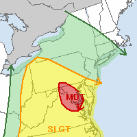
Day 1 Severe Weather Outlook showing a rare moderate risk over the DC Region, and less risk in our area. (Storm Prediction Center)

Storm Prediction Center has issued a rare Moderate Risk (the second in just one week on the East Coast), this time farther to our south over the Mid-Atlantic including the Capital region as well as parts of Maryland and Virginia. Strong to severe thunderstorms are expected there, with a heightened potential for tornadoes, some potentially strong. For more information on the severe weather threat there, visit our friends at Capital Weather, the Storm Prediction Center, or the Washington D.C National Weather Service. In our area, the severe weather threat will much less (in fact, it will be quite low).

The culprit in the difference in weather? A warm front, which lies between the Mid-Atlantic and our area. This warm front is allowing for warm and unstable air to surge into the Mid-Atlantic, while keeping our area cooler and more stable. Overnight tonight, this front will move north and a cold front will sweep through, bringing a period of rain (possibly heavy at times) through the area. A rumble of thunder or a gust of strong wind isn’t out of the question, but the severe weather threat is overall expected to be very low.

The good news is that clearing is expected by late-morning on Saturday, giving way to fair weather and temperatures in the 70’s by Saturday afternoon and evening. Some showers and storms could be scattered around on Sunday afternoon, but the weekend certainly doesn’t look like a washout.