Surge of big heat will kick off Summer 2012

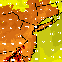
The seasons first burst near-dangerous level heat is likely to arrive rapidly by Wednesday afternoon throughout the forecast area. A ridge in the mid and upper levels of the atmosphere is expected to rapidly build beginning Tuesday, beginning the advection of the warmest air the area has seen so far this season.  Tuesday will likely end up near average with high temperatures ending up in the mid 80’s, ending a streak of normal to slightly-below normal temperatures which began almost a week ago. By Wednesday, the playing field will be completely change as the pattern will re-adjust setting the stage for big heat. High temperatures on Wednesday are expected to rise into the mid to upper 90’s throughout most of the area, with the potential for a few near-100 degree readings in New Jersey. With low temperatures in the upper 70’s to near 80 Wednesday Night into Thursday, temperatures will be off to a fast start once again. Highs on Thursday could reach the upper 90’s to near 100 in more than a few locations. Although it will, of course, be cooler near the shore…a big sea-breeze is not expected. West winds off the hot and dry land to our west will end the threat for the ocean-influence away from Eastern Long Island.
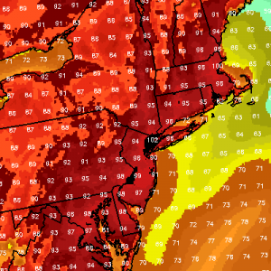
The National Weather Service has issued Excessive Heat Warnings for parts of New Jersey (likely to include NYC by Tuesday evening). The aforementioned heat, coupled with dew points in the 60’s will lead to Heat Index values over 100 in many spots during hte afternoon hours on both Wednesday and Thursday, which are near-dangerous levels. Remember, strenuous outdoor activities or prolonged exposure to the sun without hydration in such temperatures can lead to heat-stroke. Plan ahead and plan carefully — but most all, if you can, enjoy the beautiful summer weather which is on the way. Summer officially begins this Wednesday June 20th, 2012 during the summer solstice, which occurs at 7:09pm.

Warm up, then heat wave loom this week

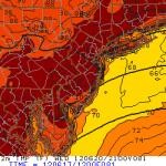
Forecast models are beginning to come into better agreement on what looks to be a gradual warmup towards above average temperatures to start the new work week, followed by several days of heat with temperatures over 90 degrees in many locations. A large ridge in the mid levels of the atmosphere and high pressure at the surface is to blame, as a south-westerly flow in the atmosphere will advect in some of the warmest air of this years warm season to date. The humidity will be on the rise as well, with models pinning upper 60’s F dew points combined with 90+ F temperatures beginning Wednesday and likely continuing on Thursday and Friday. It remains to be seen exactly how long the heat will last (a typical heat wave around our area lasts around 3 days), before thunderstorms become a threat with any trough or cold front that approaches the heated/unstable atmosphere Regardless, the weather looks to take a summery turn this week. Early-forecast high temperatures for the middle and end of the week (Wednesday) are in the mid 90’s with some warmer readings likely inland and a few cooler readings near the shore.

If you’re looking to head to the beach this week, we’ll have a full forecast out Monday morning. There may be a seabreeze in some locations along the shore during the heat wave – but early indications are that the seabreeze may be strongest on Friday. We’ll keep you posted on the best beach days as the heat draws closer.

After rain, near average temperatures return

It has certainly felt a bit cooler lately, especially after an early surge of heat in April and parts of May. You would think, given the past few weeks, that we might be below-average in the temperature department. . But despite a pattern which has featured several days of rain and clouds, the first (almost) half of June 2012 has averaged temperatures near normal. The story of this week will be a similar one, with rain on Tuesday and early Wednesday giving way to near average temperatures the rest of the week and leading into the weekend. A weak trough off the East Coast will prevent a surge of heat which is expected to effect the Midwest and Central United States beginning later this week, but temperatures will still warm up to slightly above normal levels by then. The good news, for our area, will be a general lack of high-precipitation events through the time period. The rain early Wednesday looks like the last-hoorah for the rain until at least the weekend, as high pressure will be sandwiched in between our area with a trough off to both our west and east. We could see clouds back in the forecast, however, by this weekend in response to a backdoor front and some marine/ocean air being pushed inland.

Stay tuned over the next few days for updates on the weather this weekend — including the timing of clouds from the backdoor front and any potential precipitation events down the road.

Chance of storms continues the next few days

An upper level low continues to spin over the Northeast US as we reach the middle of the week, and although it is forecast to slowly erode and then

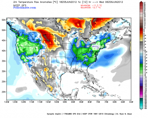
Temperature departure from normal expected on Wednesday morning from the GFS model (Policlimate)

drift eastward over the Northwest Atlantic, the system will continue to bring impacts to the area on both Wednesday and Thursday. Scattered showers and thunderstorms are forecast to develop both days, in response to energy in the atmosphere that is meandering around the upper level low pressure system. Such an occurrence is not overly rare, but the system is providing unusually cool temperatures for this time of year. With high temperatures in the low 60’s on both Monday and Tuesday, New York City saw temperature departures from normal of nearly -10 degrees — a stark difference to the theme of the past several months. The showers and thunderstorms which are possible on both Wednesday and Thursday could also add to a building statistic of days with rain — 25 of 36 days featured rain dating back to May 1, 2012. Forecast models continue showing temperature departures of 3 to 5 degrees below normal on Wednesday, with a rebound towards near normal on Thursday. The mornings will be cooler than normal (see the image on the right, valid early Wednesday morning) but the afternoons will warm up towards near-normal as we reach the end of the week.

The cool air will only stick around for so long, though, so don’t be totally fooled by its presence. Forecast models are in good agreement on a return to normal temperatures. In fact, many of them are already hinting at a return of potential heat (90+ F temps) by the middle of next week, and continuing through the middle and end of the month.