-2")
Forecast: Unsettled Tuesday, improving by mid to late week

NAM Forecast model showing showers and plenty of clouds in the area on Tuesday Night into Wednesday morning. Clearing is expected by later on Wednesday afternoon.
A stationary front to our north will provide the area with cloudy skies and the chance of showers throughout today and tomorrow. Your morning commute should be dry, but once the afternoon rolls along, the chance of showers will increase. It will not be a washout, but it’s probably still a good idea to keep the umbrellas handy just in case. Temperatures will remain mild, however, with highs in the mid 60s, as the eastern half of the country remains in a ridge.
The best chance for heavier rain, however, will be overnight tonight into early tomorrow morning, as a weak shortwave moves into the area, enhancing the lift and moisture associated with the stationary front. The NAM simulated radar for tomorrow night shows the heavier showers pretty well. The showers for the most part will have moved out by tomorrow afternoon, but a few still may linger, and skies will still be mostly cloudy.
The front will clear the area by tomorrow night, and the resulting weather should certainly improve for Thursday and Friday. Some clouds will still linger, but the sun will be out and temperatures should rise into the upper 60s and lower 70s.
Today: Skies will become overcast and showers will be around the area for the afternoon, especially for locations north of the city. Highs will be in the mid 60s.
Tonight: Showers become a bit more numerous, with moderate to heavy rain even possible at times. The whole night won’t be a washout, but definitely have the umbrellas handy. Temperatures will fall into the upper 50s.
Tomorrow: Early morning showers should give way to primarily mostly cloudy and cloudy skies, with isolated showers around. Highs will be in the mid and upper 60s.
Keep reading for more details including an update on the potential tropical system this weekend..
Tomorrow Night: Showers taper off and cloudy skies to start the night will slowly become partly cloudy as the night progresses. Lows will be in the upper 50s.
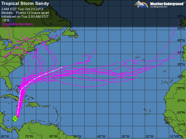
00z GFS Ensemble Tracks – most are out to sea, but some of them show “Sandy” approaching the East Coast.
As far as the big storm threat for early next week is concerned, not much has changed from our Long Range Technical Discussion. I will present one quick image, however; the 00z GFS ensembles. The purple lines represent the track of the ensemble members of the GFS computer model. Most of them are out to sea, but several have caught onto the idea of bringing a major storm to the east coast.
Stay tuned to our Facebook and Twitter for continuous updates!
Leave a Reply
Want to join the discussion?Feel free to contribute!