Another autumn snowfall possible Tuesday

NAM Model showing simulated radar precipitation types at 2pm on Tuesday November 27th, 2012. Notice the rain/snow line over Central NJ and along coastal areas of New Jersey, Long Island, and Connecticut.
Storm Overview
[spacer size=”1″]
Many areas having already received a pre-winter snowfall in Early November, a second wintry system is on the way Tuesday — one which could provide another light to moderate snowfall before the start of meteorological winter on December 1st. November snowfalls are not unheard of, but are rare — and seeing two in one month is exceedingly rare. This storm doesn’t look to pack the same significant potential as the first one, as it will be a much weaker system with less heavy banding. The heavy, slow moving bands of snow are what were largely responsible for the high snowfall amounts in the early November event, known in meteorology as deformation bands. These bands form where storms produce enhanced areas of lift and can often produce snowfall rates of 1-3″ per hour. Our system is swinging through from the west-northwest, and will eventually move off the coast and start strengthening once it’s well to our northeast.
Even despite the system being suppressed a bit, without any explosive strengthening or development, there will be a some moderate precipitation. The question becomes whether or not this precipitation can fall and stick as snow. This will be much easier inland, and in the higher elevations. Near the city and on the coast, there will be warmer air in place at the surface. This means that in order to cool the air, heavy precipitation needs to fall. Forecast models indicate that precipitation could fluctuate between rain and snow in these areas, depending on how heavy the precipitation is falling. This does not bode well for accumulating snow in these areas.
Snow and rain could begin as early as 8am Tuesday, and will continue throughout the day. The heaviest precipitation is expected to fall between 12 and 4pm, with precipitation lightening afterwards..but possibly continuing through the evening rush hour. By later Tuesday evening, the storm is expected to head to our north and east and precipitation will wrap up over Long Island and Connecticut.
Keep reading for details and forecast graphics/snow forecast maps…
Storm Forecast
[spacer size=”1″]
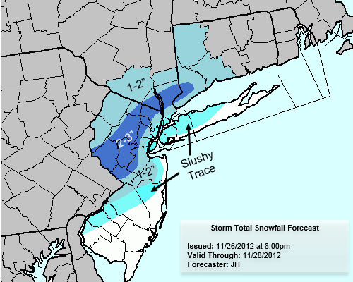
Our forecast remains slightly more uncertain than normal for the time period — as we would usually have fairly good confidence in a forecast at this juncture. This system provides a good amount of uncertainty, stemming from the surface temperatures and snowfall accumulation. Our official forecast calls for snow and rain in New York City throughout the day on Tuesday, with only minor accumulations possible on grass and colder surfaces. Much of the same will be true over Central NJ and Western Long Island. Farther east, on Eastern Long Island and along the NJ Shore and Southern NJ, little to no accumulation is expected although a trace or so is possible. In the immediate suburbs of NYC as well as much of CT and Interior New Jersey, 1 to 2 inches of snow is possible by the time the storm wraps up on Tuesday. Snow will be falling and melting for a while, and may mix with rain when it lightens up. Finally, a band of 2 to 4 inch totals is expected from Western NJ into Interior Central and Northern NJ and possibly as far north as Southeast NY. This band remains somewhat uncertain and its eventual positioning could change the forecast dramatically.
Check out all of the official graphics and information below.
Forecast Graphics
[spacer size=”1″]

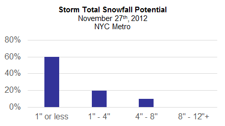
Our snowfall probabilities table for most locales within the NYC Metro Area. This reflects the percentage chance of 1″ or less, 1-4″, and 4-8″ of snow. Other higher amounts were removed due to low likelihood.


Leave a Reply
Want to join the discussion?Feel free to contribute!