-2")
Forecast: Warmup will preface Easter showers
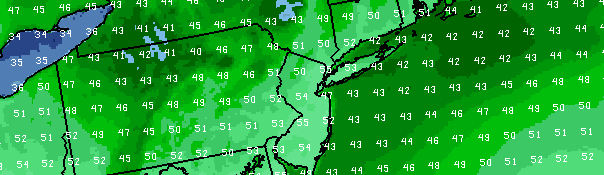
The NAM model forecasting temperatures warming into the mid and even upper 50’s on Easter Sunday, ahead of a disturbance which will bring afternoon clouds and showers.
A cold upper level low, which meandered over the Northeast United States throughout much of the last five or more days, is finally on the way out late this week. The weakening west-northwesterly flow and warming temperatures aloft will allow for a bit of a warm up at the surface as well. In addition, showers and clouds which plagued the forecast this week are expected to become less frequent. The warmup is expected to continue through the weekend and into Easter Sunday, when temperatures could warm into the upper 50’s.
A weak disturbance along a warm front will make the Easter forecast a bit more complicated, however. Despite the warmup, clouds and showers are expected to develop by afternoon and continue through evening. Temperatures will again fall into the 40’s, as a weak surface low moves offshore. All is not lost, however, as the main front will lag behind into Monday. This will open up the window for an even warmer day on Monday — as temperatures could exceed 60 degrees in front of the front.
Friday: Sunny and a bit warmer, with highs in the low to mid 50’s. West winds around 10 miles per hour. A slight chance of showers in the afternoon.
Friday Night: Mostly clear and cool, with lows in the 30’s. West winds around 10 miles per hour.
Saturday: Partly sunny, with highs in the middle 50’s. West winds around 10 miles per hour.
Sunday: Partly sunny early, with highs in the mid to upper 50’s. Then increasing clouds and showers likely.
Monday: Partly cloudy with a high in the upper 50’s to lower 60’s. A chance of showers in the afternoon and evening.
Leave a Reply
Want to join the discussion?Feel free to contribute!