Despite lowering humidity, more heat looms

The past few weeks have featured high humidity values and warmer than normal temperatures — with an uncomfortable airmass lingering throughout the area. Over the next few days, a bit of a break in that airmass is likely as a cold front nears the area and brings in not only some clouds, but slightly cooler air. The front won’t make much progress past our area, though, as it runs into a strong Western Atlantic Ridge. The weakening disturbance associated with the cold front will eventually become absorbed in the mid – level atmospheric flow, and the forecast models suggest that the West Atlantic ridge will win the battle.

As the front stalls and dissipates, a building ridge over the Central United States will make its way east. The end result? A brief break — but then a return to the heat. Forecast models, in fact, have hinted at the potential for temperatures at the 850mb level to approach or exceed 20 C next week, a benchmark for “Hot” weather in our area.

GFS model forecasts of height and vorticity at 500mb. Valid Thursday 7/11/2013 (left) and Monday 7/15/2013 (right).

GFS model forecasts of height and vorticity at 500mb. Valid Thursday 7/11/2013 (left) and Monday 7/15/2013 (right).

Pictured above, the GFS model shows the forecast heights and vorticity at 500mb (mid levels of the atmosphere) valid both Thursday (left) and Monday (right). The important features are highlighted, with the Western Atlantic Ridge and Central US Ridge in yellow on the left side. The vorticity (red) in our area associated with the cold front has created clouds and showers today. However, by Monday, the ridge has completely taken over the pattern and “domed” over the Central and Eastern United States.

As a result, despite the break in the heat and humidity over the next few days, it appears that next week should be highlighted by a return to heat — with temperatures approaching the mid 90’s by the middle part of the week. Stay tuned for any potential heat related watches or warnings– and prepare to stay cool!

Cold ocean waters creating quite a stir

If you have spent any time at all visiting the shores of New Jersey or New York this summer, you’ve probably left with one thing on your mind: that water was entirely too cold! The bad news is, it’s not all in your head. The waters are actually cold — and colder than normal for this time of year on a local scale. The good news is that a changing pattern will help to warm the waters with time over the next few weeks. The question that remains, though, is: What is causing the uncomfortably cold ocean waters?

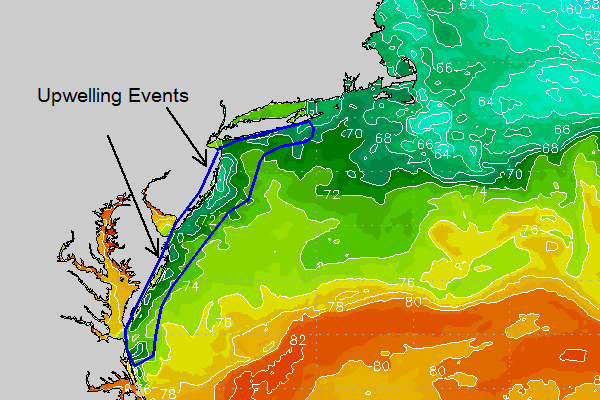
The answer: Upwelling. Sounds complicated, but it actually is a fairly simple process. Winds that blow across the oceans surface push the top layer of warming water away. The water then rises up from beneath the surface to replace the water that was pushed or “blown” away by the winds. The waters below are typically much cooler, and so the water that rise to the surface is chilly. Upwelling events over the past few weeks along the shores of Maryland, Delaware and New Jersey have left beachgoers shivering.

Regional Sea Surface Temperature data shows a local pocket of cooler waters, owing to upwelling which has occurred along the areas shoreline.

Regional Sea Surface Temperature data shows a local pocket of cooler waters, owing to upwelling which has occurred along the areas shoreline.

A glance at the regional or local sea surface temperatures reveals the upwelling which has occurred near and long the Mid-Atlantic coasts. There are various things at play on the above sea surface temperature map. You can see warm ocean waters along the Gulf Stream (bottom right), cooler waters in the Northwest Atlantic near New England, and the local upwelling events keeping the waters cooler than surrounding areas. The Atlantic as a whole is running above average — with our cool waters classified as a very localized event.

Over the next few days, a more onshore flow is forecast to develop. This is important, as the changing wind direction will help to moderate the water temperatures — albeit slowly. Those of you headed to the beach over the next week or two should certainly take that as welcomed news.

End of overly humid airmass may finally be in sight


To say that it has been warm and humid of late may very well be an understatement. In fact, the persistence of the warm and humid pattern has been quite remarkable. Dew points have averaged near or over 70 degrees for a good part of the past week throughout the area, and more recently temperatures surging into the upper 80s to low and mid 90s have left the airmass feeling not only hot and humid, but stale and uncomfortable.

Much of that will change by the end of this week, as a trough slowly settles into the Eastern 1/3 of the United States. Over a more prolonged period of time, the pattern has been “wash-rinse-repeat” with a trough giving way to heat and humidity, followed by another trough several days later. Regardless, before we can talk about cooler temperatures and a bit of a more refreshing airmass, we will have to deal with showers and thunderstorms.
Regional analysis this morning suggested an increase in clouds when compared to the past several days, owing to decaying storms from the Ohio valley last night and a continued moist airmass. This will keep the sun away for a while today, but more importantly it will also mitigate instability — which will keep the threat for severe thunderstorms at bay this afternoon. There could still be a few strong storms as a favorably placed jet stream and frontal boundary approach the area. The Storm Prediction Center has placed areas to the west of New Jersey and NYC in a “Slight Risk” for severe storms, but has kept our area in a lower risk for the reasons discussed above.
Unsettled weather will continue into Thursday, but by that point humidity will be on a noticeable decline with the airmass feeling more comfortable. Such a comfortable change will probably more than welcomed by most.

Slightly Cooler Temperatures This Week, But The Same General Pattern Remains

We have had a stagnant warm and very humid weather pattern over the past couple of weeks, and that general theme is expected to continue. The chance for a scattered afternoon thunderstorm each day also exists, with perhaps a bit more of a widespread threat on Wednesday or Thursday, depending on the timing of an impulse traversing the northern tier of the country. Then, for next week, bigger heat moves back in with perhaps the hottest temperatures of the summer.

Radar as of 3:15 p.m. EDT shows storms developing to our west due to daytime heating. Some will try to move towards NYC later this afternoon, but they should not be severe and may weaken as they do so.

Radar as of 3:15 p.m. EDT (today) shows storms developing to our west due to daytime heating. Some will try to move towards NYC later this afternoon, but they should not be severe and may weaken as they do so.

Today, we still have a weak shortwave in our area, but it’s a bit weaker than it was yesterday, so our shear is a bit weaker for thunderstorms. Also, the Western Atlantic Ridge has pushed back to the east a bit, which helps to shunt some of the warmest temperatures back to the east. Thus, temperatures today and throughout the week should be several degrees cooler than they were yesterday. Still, though, warm and humid conditions will prevail — with temperatures in the mid to upper 80s throughout the week.

As the shortwave moves east and daytime heating continues, thunderstorm coverage should increase. Since shear and mid-level winds are low, the storms will mainly be pulse severe in nature and slow-moving. Steep low-level lapse rates and high moisture make strong winds and heavy rain the main threats. A widespread severe weather threat is not expected, however.

For Tuesday, the shortwave will move out to sea, with weak height rises behind it, thus limiting any lifting mechanisms for thunderstorms. We do not expect much in the way of thunderstorm activity for the local area tomorrow. A strong shortwave north of the Great Lakes will become embedded within a longwave trough, perhaps leading to an MCS spreading eastward into western PA. Perhaps E PA and W NJ could get indirectly affected by this towards the evening.

Storm system north of the Great Lakes, combined with the Western Atlantic Ridge will usher in quite warm and humid conditions for Wednesday, with the chance of afternoon thunderstorms. The best threat, as of now, will be north and west of NYC.

The European Operational Model shows a storm system north of the Great Lakes, combining with the Western Atlantic Ridge to usher in quite warm and humid conditions for Wednesday, with the chance of afternoon thunderstorms. The best threat, as of now, will be north and west of NYC. Image courtesy of the WSI Model Lab.

For Wednesday, that strong disturbance will continue to move eastward, creating stronger lifting mechanisms for thunderstorms over a more widespread area in the northeast. However, the disturbance appears to be a bit too far northwest during peak heating for the main thunderstorm threat to be over our area. The storm’s trailing warm front will probably be located in Northern New England, so the strongest mid-level flow and lifting mechanisms will be to our north. SE Upstate NY could be affected, however, and more isolated storms could press towards our area; especially considering that instability should be pretty high. Regardless, the probability of unsettled afternoon weather is a bit higher on Wednesday than the previous days. Out ahead of that disturbance, stronger SW flow will be ushered in from the Gulf, and the Western Atlantic Ridge temporarily pushes back to the west, creating the hottest and most humid day of the week. Temperatures should surge to the low 90s.

For Thursday and the weekend, there is a tad bit of uncertainty. The cold front to the south of the warm front will move eastward, but then get halted a bit due to the ridge to the east. The close proximity of the front will allow for more cloud cover and cooler temperatures than on Wednesday, with temperatures sliding back into the mid to upper 80s. The chance for rain and thunderstorms may be a bit higher on Thursday than on Wednesday, but severe potential seems low for now. The exact position of where the front gets held us will affect how much rain we see — once the front gets east of us, temperatures should cool off even more, humidity would drop a bit, and the rain threat could lower significantly for Friday and the weekend.

European Ensemble Mean data shows a strong heat dome building into the Midwest, along with the strong Western Atlantic Ridge building back in. This should help to create another heatwave for next week. Image courtesy of the WSI Model Lab.

European Ensemble Mean data shows a strong heat dome building into the Midwest, along with the strong Western Atlantic Ridge building back in. This should help to create another heatwave for next week. Image courtesy of the WSI Model Lab.

For next week, we may have to watch for more widespread heat to work its way back into the area again, similar to last week and this past weekend — only perhaps a tad warmer. Lots of medium range model guidance is showing the Western Atlantic Ridge building back even further west, which would help to usher in more heat and humidity from the Gulf. Additionally, the heat dome that previously gave the southwest record heat will become more expansive and shift eastward towards the Midwest. This will provide strong heat to an area that is often our source region for the biggest heat. If more westerly flow can persist, the expansive heat in the Midwest would push its way eastward, and get downsloped through the Appalachians and into our area. The downsloping, westerly winds from a very hot source region is what often creates our biggest heatwaves.

If the Western Atlantic Ridge can combine with the Midwest heat dome, a week-long heatwave could ensue. If not, then perhaps last week and last weekend would repeat itself. There may actually be too much humidity from the Western Atlantic Ridge for any 100 degree readings, since humid air is harder to heat than drier air. But mid 90s for a few days next week certainly appear to be in the cards.