-2")
Wednesday Forecast: One more splendid day
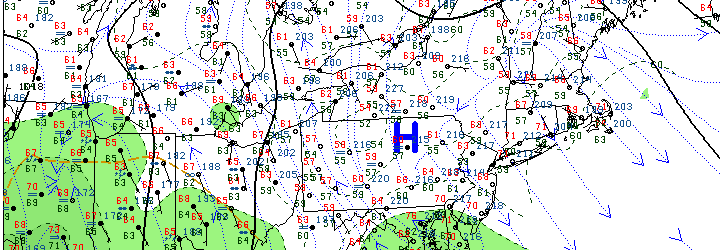
Northeast surface analysis from the morning of July 31, 2013 showing high pressure controlling the weather pattern for one more day, but moisture approaching from the southwest.
The first half of this current work week has given us the best summer has to offer. Clear blue skies, low humidity, and near-average temperatures with highs reaching the low to middle 80’s throughout the area. The low humidity, in particular, has kept temperatures feeling comfortable and the air feeling crisp. Much of the same will be true on Wednesday, as a high pressure system hangs on for one more day before slipping off the coast and weakening. High clouds will stream in during the later part of the morning into the afternoon, with some mid and lower clouds possible by the end of the day. Generally, however, pleasant weather will persist.
The mid and high clouds are the first sign of an approaching disturbance which will affect the area on Thursday. A warm front and associated low pressure system will move towards the area by Thursday morning and afternoon, bringing with it a high likelihood of showers and periods of rain as well as an increased chance of thunderstorms. Most noticeably, the humidity will rise and the winds will pick up out of the east-southeast, especially in any stronger storms.
Stay tuned for the latest on the approaching storm system, but first be sure to enjoy the gorgeous Wednesday which is on the way. Be sure to check in on our social networks for frequent updates.