-2")
Summer Makes Its Brief Return and Fall Weather Returns this Weekend
After what has been a very cool August with fall-like temperatures, the NYC Metro area has a chance to do something that has not been done yet this month: hit 90 degrees! The rest of today will feature temperatures in the mid to upper 80s with humid conditions, due to a warm, moist southwesterly flow, as some west Atlantic ridging has built back into the region. It’s not nearly to the same extent as earlier in the summer when we had record heat and humidity, but it’s certainly enough to make it feel like summer again.
With clear skies and calm winds for tonight, temperatures will drop pretty quickly through the evening, due to radiational cooling. Certainly a great evening for a beach or boardwalk stroll, as temperatures will drop into the low to mid 70s during the evening. Overnight lows will be in the mid to upper 60s for most of the region. With temperatures dropping pretty quickly towards the dewpoints, some patchy fog is possible late tonight and for early commuters tomorrow morning.
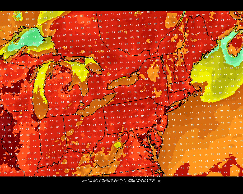
The high-res 12z NAM shows highs approaching 90 for parts of the region tomorrow afternoon.
Tomorrow: Looks pretty similar to today. It will be sunny, and there may be a few isolated spots that hit 90 degrees, as the 12z 4-km NAM shows, especially in more urban NE areas of New Jersey — closer to Newark. The Rutgers Gardens weather station in New Brunswick may also hit 90 degrees — something that has not happened all month! NYC has an outside shot of 90 degrees as well, but they may end up staying in the upper 80s. Long Island will probably rise into the mid to upper 80s before a seabreeze sets in. It will be a bit muggy as well, really making it feel like summer, so get to the beach if you can!
As an area of high pressure slides eastward, a cold front will begin to approach for Wednesday night, increasing the southerly flow out ahead of it even more, which helps to increase clouds and humidity. Wednesday night will feature many areas not getting below 70 degrees, so it may be a good time to sleep with the ACs on.
Thursday: Looks to be warm and humid, but clouds will probably prevent high temperatures from reaching 90 degrees. With the cold front approaching and humidity levels on the rise, showers and thunderstorms are possible on Thursday afternoon, especially west of NYC. Any activity will slide through the region during the evening and overnight as the cold front crosses the area. Although showers and thunderstorms can be expected, severe weather potential remains low as of now, due to a lack of favorable wind profiles and wind speeds throughout the atmosphere.
Friday and the weekend: There may still be some lingering clouds and showers — especially for eastern sections — on Friday morning before skies clear. Highs should be in the low to mid 80s. Temperatures really cool off on Friday night as drier air moves in. The gorgeous, low humidity, cool weather from earlier in the month looks to return for the weekend, with lows in the low 60s and highs in the upper 70s, with sunny skies. Perhaps even some spots will see 50s for lows.
Enjoy the summer-like week and the fall-like weekend, everyone!
Leave a Reply
Want to join the discussion?Feel free to contribute!