Tuesday begins transition into cooler pattern
Meteorological Autumn began September 1st with a warm, humid and unsettled weather pattern. Now, after just a few days, some significant changes are on the way. A cold front is shifting eastward off the Mid Atlantic and Northeast coast early this Tuesday morning, with some isolated showers and thunderstorms (one severe-warned storm on Long Island) possible on the Island and into Southern New England. For the rest of the area, a cloudy and drizzly start will give way to clearing skies by later this afternoon, as well as lowering humidity. The front is being driven off the coast by a mid level disturbance over the Great Lakes, which will be shunted eastward by another stronger disturbance over Southeast Canada. This feature will become important for us by later this week, as it ushers in a very cool airmass.

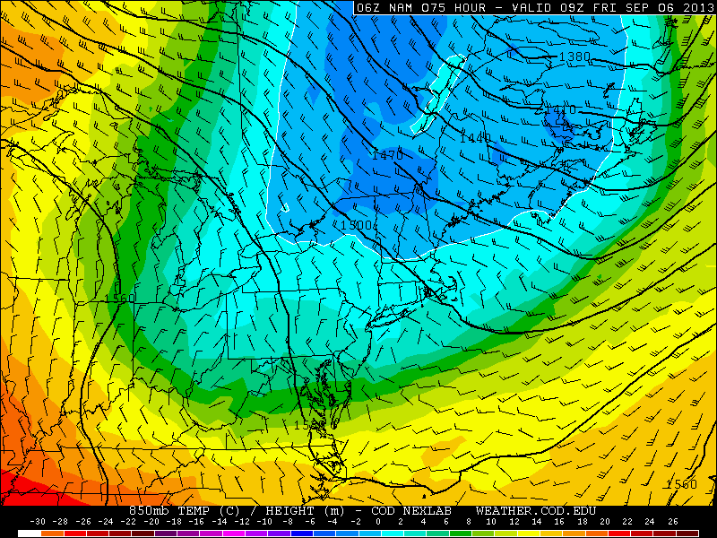
NAM model’s forecast temperatures at the 850mb level in the Northeast US this coming Friday morning. Notice the values near or below zero over New England, and cold values extending as far south as NYC.
A mid level ridge spike over the West-Central United States will allow a cutoff low over Eastern Canada to drop east-southeast, and the core of a cool airmass will clip the Northeast US later this week. Forecast models are indicative of 850mb temperatures dropping into the single digits by Thursday and Friday, with near or below 0 C readings over New England. Pleasant weather is expected, with plenty of sun, but it will certainly feel like autumn late this week.
Forecast high temperatures this week begin in the 80’s (Tuesday), but fall into the 70’s by Thursday and Friday, with overnight lows falling dramatically Thursday Night and early Friday morning, when some interior locations could fall well into the lower 40’s. With that said, the forecast looks pleasant with minimal rain chances moving forward.

Leave a Reply
Want to join the discussion?Feel free to contribute!