-2")
Update: Cloudy and drizzly now, heavier rains tonight
After a brief bout of rain this morning, most of the area is currently in a dry-slot. Lots of dry air has filtered into the region thanks to a high pressure system to the north. And considering the storm is still well to the south of the area, there is not enough lift in the atmosphere at our latitude to consistently supply rain. This is why our forecast called for the heaviest rain to be tonight and tomorrow morning, rather than today.
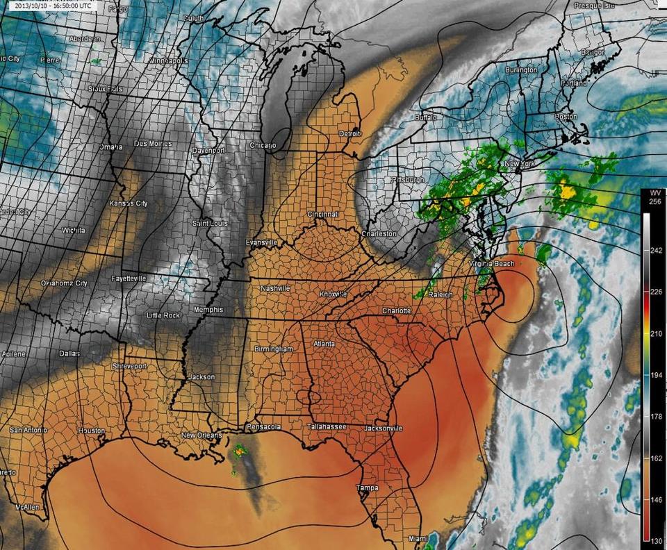
The water vapor imagery shows dry air filtering into our storm system, but lots of cold cloud tops to the east that will eventually head our way.
Water Vapor satellite imagery from this afternoon showed the atmospheric setup, and associated sensible weather occurring in our area, fairly well. The tan colors represent a ton of dry air, and even the white/grey colors are relatively dry air as well. Current atmospheric soundings show dry air still being persistent at the 800-900mb level. As the storm system continues to slowly drift northward, that should gradually change. As you can see, there is an area of bright, vivid colors off the coast of New Jersey. This is indicative of cold cloud tops, and colder cloud tops are higher in the atmosphere, since temperatures drop as you increase in height. The higher cloud tops bring back a stronger signal to our satellites, thus the brighter colors. It is these higher cloud tops that have more organized rain.
We are currently in the grey zone; sandwiched between two areas of colder cloud tops/lift — meaning a subsidence/sinking air zone — explaining the dry-slot. But those colder cloud tops off the coast of New Jersey will eventually pinwheel to the west-north-west towards our area, and still give us a good dousing of rainfall tonight and tomorrow morning. Winds will also increase when that occurs as well. Concerns for coastal flooding and some beach erosion will continue along the area shores.
That being said, it seems fairly safe to say that some of the 4-6″ rainfall totals that the high-resolution models were showing appears to be way too generous, given the breaks in heavier precipitation that we are currently seeing. Our forecast briefing that was issued yesterday afternoon which calls for 2-3″ of rain still appears to be mostly on track; one difference is that today’s break in the rain will be a bit longer. The briefing can be found here: https://docs.google.com/document/d/1K0iOEw2fBzxjOPJ0d19PgXO0YuKhVbkddzqWEu0hBN4/edit
As always, stay tuned to our social networks for any further updates.
Leave a Reply
Want to join the discussion?Feel free to contribute!