R.I.P Comet ISON

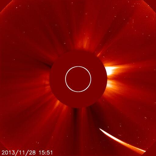
Comet ISON, the sungrazing comet which grabbed the attention of millions when it was discovered in September 2012, reached the end of its five million-year long journey towards the sun today. Unfortunately, for all parties involved, the Comet did not make it around the sun in one piece. ISON brightened dramatically yesterday, but then was seen to become less bright and elongate this morning. As it dove towards its perihelion, high resolution imagery showed no visible nucleus — and athe brightest part of the comet was in its tail. A steady dust trail also signaled the eventual demise of the comet, as its nucleus fragmented and apparently disintegrated just an hour or less before perihelion. As of now, ISON has not appeared on the other side of the sun on any of the handful of NASA cameras pointed at the sun specifically to observe it today.

The result of Comet ISON evaporating just prior to perihelion will be disappointing for all on the ground — as Comet ISON will never be able to be observed again. The tail of Comet ISON still remains dragged out towards the sun, a haunting remnant of its entrance into the suns very harsh environment. But the emptiness of any light on the other side of the sun tells the true tale — as ISON was never able to make it out. Over the next few days, scientists and amateur astronomers will certainly analyze the incredible amounts of data that were collected on ISON’s approach.

So, for the record. Sun: 1 Comet ISON: 0.

Stay tuned over the next few days for additional information.

Comet ISON dove towards the sun on November 28 2013, but never made it out on the other side.

Comet ISON dove towards the sun on November 28 2013, but never made it out on the other side.

Live Blog: Comet ISON’s biggest hour

Comet ISON reaches perihelion today around 1:40pm Eastern time, and the tension is building as it heads towards the sun. ISON is currently experiencing the most hostile conditions it will in its lifetime, with intense solar wind, incredible temperatures, and ridiculous speed as it rounds the sun. The comet brightened dramatically yesterday, and the brightness was saturating NASA’s SOHO LASCO satellite imagery. But today, the comet has faded as it approaches the sun. In fact, the newest reported attempts of photometric of the center of ISON suggest “there may be no active nucleus at all anymore”.

ISON will reach perihelion today, and we will know the fate of the comet shortly thereafter. If it survives its trip around the sun, it may put on quite a show as it comes around the other side of the sun..and may be visible from earth during the first and second weeks of December. If not, the comet may not emerge and will not be seen again. Our live blog will follow along with new images and information over the next hour. So stay right here!

Comet ISON rounding towards the sun on November 28th, 2013.

Comet ISON rounding towards the sun on November 28th, 2013.

Read more

Complex storm system wraps up later today

A dynamic and complex storm system (not a nor’easter by definition despite the efforts of some to call it such) continued to menace the East Coast early on Wednesday, during one of the biggest travel days of the year. Significant delays were reported this morning at several area airports, owing to the strong winds and heavy rain. Through this afternoon, periods of heavy rain are expected to continue. The center of low pressure has moved north and east of the area into Southern New England, but lower pressures extending southward and a noticeable thermal boundary will serve as a “highway” for continuing rainfall.

With time, however, this boundary will shift eastward and the low pressure center will shift north/northeast. The most noticeable effect of this will be the temperature and wind shift. Warm temperatures from earlier this morning (60’s observed throughout much of New Jersey and even into New York City) will become a distant memory as westerly winds behind the aforementioned thermal boundary will usher in colder air. Temperatures are forecast to fall back into the 40’s by later today, and 20’s and 30’s overnight tonight. Snow showers cannot be ruled out by later this evening throughout the area in the wake of the strengthening low pressure center. The heaviest rain is expected to wrap up by mid-afternoon, but will linger into the evening across areas North and East of NYC.

Water vapor satellite imagery from Wednesday 11/27/13, showing a tropical moisture fetch with a storm system in the Eastern US.

Water vapor satellite imagery from Wednesday 11/27/13, showing a tropical moisture fetch with a storm system in the Eastern US.

Read more

Widespread impacts from midweek storm

A pre-thanksgiving storm system will create a travel nightmare from Tuesday Night through Wednesday, providing a myriad of threats up and down the east coast. Before we dive into the details of the storm system, what’s causing it to occur, and what you can expect in our area, we can lay out a few things we know as fact as of Tuesday morning. First, there will be significant travel delays on Wednesday. If you’re driving, flying, or using some other form of travel in the Mid-Atlantic or Northeast US, expect delays…likely significant. Second, Thanksgiving day itself won’t be all that bad. So once you make it where you need to be, the weather for actual Turkey Day looks to be fairly pleasant, albeit a bit cold. In our post below, we break down the storm system and what you can expect from it.

Visible satellite imagery from Tuesday morning, showing a significant storm system forming in the Southeast US.

Visible satellite imagery from Tuesday morning, showing a significant storm system forming in the Southeast US.

What’s the deal, how is this storm forming?

Two pieces of energy in the jet stream across the Central and Eastern United States will phase on Wednesday, essentially very close to our forecast area. A low pressure area will develop from the Southeast States northeastward into New England. As it does so, warm air will stream up the Eastern Seaboard — as will significant amounts of precipitation in association with a strong low level jet and moisture transport. The low pressure system will then rapidly deepen as it moves to our north through New England and into Eastern Canada.

Read more