NYC Forecast: Chilly today, arctic air awaits this weekend

weatherrate
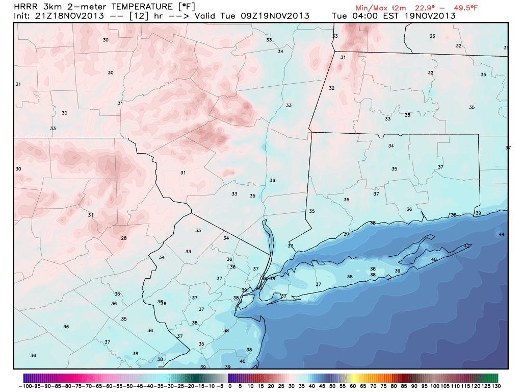
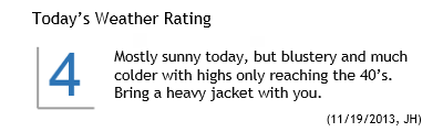
Much colder air filtered into the area late on Monday evening and continued to do so into early Tuesday morning. The change comes on the heels of a major cold front, which pushed through the early on Monday. Temperatures fell into the 30’s overnight — and the temperature drop at the 850mb level was equally as impressive, falling to near – 10 C in northern parts of the area on Tuesday morning. Highs on Tuesday will only scrape into the 40’s, with blustery winds especially early. The combination of the two will make it feel pretty cold, especially after Monday which featured highs in the middle 60’s with a very warm sun.

The forecast takes us through a bit of moderation as we look ahead to the middle of the week, as the cold airmass over the region currently will begin to lose its grip on the pattern. High temperatures look to warm a few degrees each day, from the mid to upper 40’s on Tuesday, into the mid to upper 50’s by Thursday. The moderation will come ahead of a potential arctic plunge, however, as another strong front and associated disturbance approach the area this weekend.

In the shorter term, winds calm by tonight and clear skies are expected through the overnight period with temperatures dropping into the 20’s inland and near 30 in the city/urban areas. Great viewing for the expected 730pm Minotaur rocket launch from Wallops Island in Virginia. You can catch a glimpse of the launch by simply looking southeast at that time — the rocket will appear in the skies 30 to 60 seconds after launch. More forecast details after the break.

Timing of first sighting above horizon by location, for tonight's 730pm planned rocket launch.

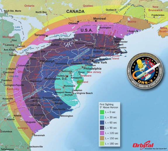
Timing of first sighting above horizon by location, for tonight’s 730pm planned rocket launch.

Read more

PM Update: Much cooler air filtering in

Behind a major cold front, which moved through very early this morning, westerly winds began on Monday. Winds picked up considerably on Monday afternoon, but the air remained relatively warm. Temperatures in the mid levels if the atmosphere remaining somewhat warm allowed for the highs to reach into the mid 60s — making for a pleasant, comfortable late-autumn afternoon. But the airmass is changing rapidly behind the aforementioned cold front.

The low pressure system which helped drag the cold front through the area deepened below 967 hPa in Southeast Canada on Monday, and much colder air will surge eastward to the south of it. Temperatures will plummet into the 20s and 30s overnight on Monday evening into Tuesday morning throughout the area — especially over the interior. Pleasant weather is expected to continue through mid-week with near seasonal temperatures.

Forecast low temperatures on Tuesday morning, from the HRRR model.

Forecast low temperatures on Tuesday morning, from the HRRR model.

Read more

Crunch time for ISON, 10 days from perihelion

The clock is ticking on Comet ISON, which is now less than 10 days from its perihelion date with the sun on November 28th. The comet began its long (very, very long) journey through the solar system when it was kicked out of the Oort cloud, a mass of ice and rock in the far reaches of the solar system. ISON is taking a not-so-well-traveled path through the inner solar system, not along the typical belt or path which comets have taken. This means a few things. First of all, ISON is unpredictable. We’ve never seen a sungrazing comet quite like it before. But second and more importantly, ISON is a great tool of study for scientists. How ISON behaves exactly will be very important to scientists and astronomers. So it is safe to say that all eyes will be on the now famous comet over the next 10 days.

What is perihelion exactly? Without getting too technical, it is the point when ISON will come closest to, or “graze” the sun. Comet ISON will feel the intense gravitational pull, incredible temperatures, and full force of solar wind from the sun. In fact, the comet is already experiencing the increasing impacts of all three as it dives towards the sun. The comet recently experienced an “outburst”, with a dramatic increase in brightness by almost 2 magnitudes — and began spewing gas and other volatiles from its surface into space. As it did so, it developed a dramatic tail (which at one point was 16 million kilometers long) and became a naked-eye object in the pre-dawn sky.

Comet ISON, imaged after its outburst on November 16th 2013.

Comet ISON, imaged after its outburst on November 16th 2013.

Read more

Windy, cooler behind major cold front

An energetic and powerful storm system moved through the Central and Eastern United States on Sunday, causing widespread severe weather. More than 50 reported tornadoes and 500 reports of damaging winds were received by the Storm Prediction Center behind powerful severe thunderstorms throughout the Great Lakes and Ohio Valley. The cold front moved quickly eastward through the Northeast states, bringing strong thunderstorms through the NYC Metro area just after 430am on Monday morning. Gusty winds were observed at many reporting stations as the storms moved through.

Monday will be a day of change to start the new work week, as the aforementioned cold front slides off the coast. Westerly winds will begin in earnest, gusting over 25 miles per hour at times during the day on Monday. Warm sun will allow temperatures to climb into the mid to upper 50s, but the airmass aloft will be rapidly changing. Dropping humidity and strong winds will be the first signs of the change. By Monday evening into early Tuesday morning, temperatures will fall into the 30s (colder inland). Highs on Tuesday will only reach into the 40s.

Severe weather reports (Tornado, Wind, Hail) from Sunday through early Monday morning.

Severe weather reports (Tornado, Wind, Hail) from Sunday through early Monday morning.

Read more