-2")
NYC Forecast: Chilly today, arctic air awaits this weekend
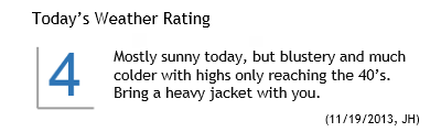 Much colder air filtered into the area late on Monday evening and continued to do so into early Tuesday morning. The change comes on the heels of a major cold front, which pushed through the early on Monday. Temperatures fell into the 30’s overnight — and the temperature drop at the 850mb level was equally as impressive, falling to near – 10 C in northern parts of the area on Tuesday morning. Highs on Tuesday will only scrape into the 40’s, with blustery winds especially early. The combination of the two will make it feel pretty cold, especially after Monday which featured highs in the middle 60’s with a very warm sun.
The forecast takes us through a bit of moderation as we look ahead to the middle of the week, as the cold airmass over the region currently will begin to lose its grip on the pattern. High temperatures look to warm a few degrees each day, from the mid to upper 40’s on Tuesday, into the mid to upper 50’s by Thursday. The moderation will come ahead of a potential arctic plunge, however, as another strong front and associated disturbance approach the area this weekend.
In the shorter term, winds calm by tonight and clear skies are expected through the overnight period with temperatures dropping into the 20’s inland and near 30 in the city/urban areas. Great viewing for the expected 730pm Minotaur rocket launch from Wallops Island in Virginia. You can catch a glimpse of the launch by simply looking southeast at that time — the rocket will appear in the skies 30 to 60 seconds after launch. More forecast details after the break.
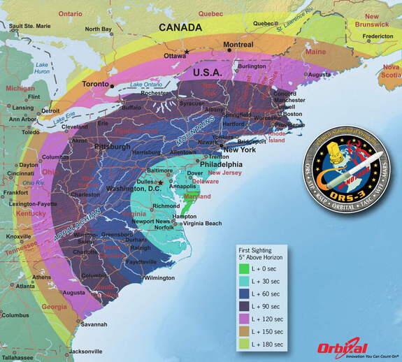
Timing of first sighting above horizon by location, for tonight’s 730pm planned rocket launch.
Arctic assault may reach the area this weekend
Although the air currently feels plenty cold, especially in comparison with what we had the pleasure of experiencing this past weekend, the real arctic assault is still looming and probably won’t fully be felt until this weekend. Forecast models are in good agreement that a storm system will shift northeastward, whether it be through the Great Lakes or just off the coast of Southern New England, and then into Eastern Canada. The exact track of this storm will make a difference in terms of snowfall potential for Northern New England, but as far as we are concerned — either one will bring the arctic hammer down by Sunday throughout the Northeast US. We’re expecting a chance of showers on Saturday in association with the disturbance which will drag the big-time cold front through the area.
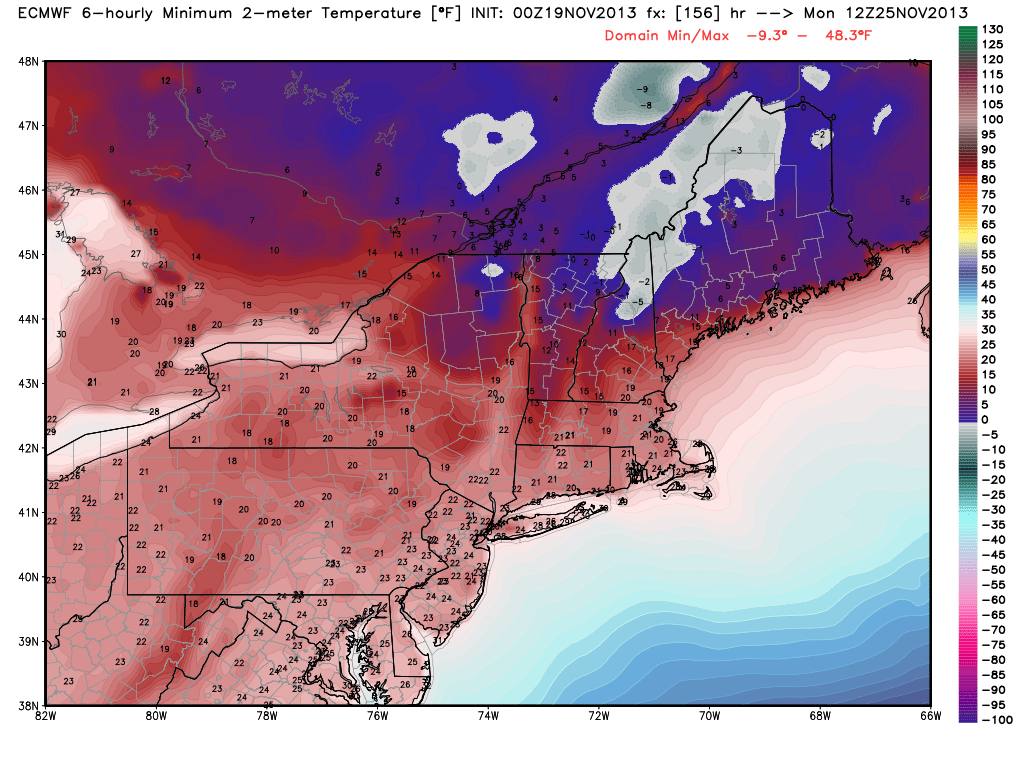
Although the extent of the arctic airmass remains somewhat unknown at this range, forecast guidance is consistent in pulling 850mb temperatures down between -15 and -20 C. The push of arctic air is aggressive and associated with a strong mid level disturbance, which slides into Eastern Canada. Despite the pattern not supporting any periods of prolonged below normal or above normal temperatures (the progressive nature is still evident), it appears that there is good agreement on a big push of arctic air this coming weekend.
Leave a Reply
Want to join the discussion?Feel free to contribute!