-2")
SPC issues rare High Risk over Great Lakes, Ohio Valley
A major severe weather outbreak is forecast this afternoon across much of the Great Lakes and Ohio and Mississippi Valleys. The Storm Prediction Center has issued a rare “High Risk” for severe weather across much of Illinois and Indiana as well as parts of Southern Michigan and Western Ohio. A highly unstable atmosphere, juxtaposed with an impressive storm system both aloft and at the surface, will act to trigger the development of impressive late-season severe thunderstorms. Impressive low level shear and wind turning will allow for the potential of widespread tornadoes, some of which could be violent. With time, the storms will organize to pose more of a damaging wind threat as they shift eastward towards the Ohio Valley. For more on the developing threat, stay tuned to the Storm Prediction Center page which will display all outlooks, watches and warnings.
In our area, the SPC has extended a “Slight Risk” for severe weather to include all of New Jersey, New York and Connecticut. As the associated cold front sweeps through the Ohio Valley and eventually the Northeast US later today, the potential for isolated strong wind gusts is expected to continue. The threat, and intensity of the storms, is not expected to be nearly as severe as it will be back across the Great Lakes and Ohio Valley.
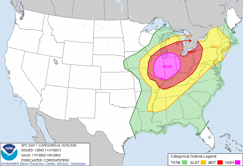
Storm Prediction Center Day 1 Categorical severe weather outlook from 11/17/13, showing a High Risk over parts of IL, IN and OH as well as a Slight Risk in the NYC Area.