-2")
Warm weekend, severe weather to our west
Warmer weather settled into the area this morning behind a warm front, which moved northward as a result of a strong system over the Central United States. The warm weather comes on the heels of some of the coldest weather so far this season, which swept through the Northeast on Tuesday. The snow and cold seems like an afterthought at this point, with temperatures well into the 60’s and plenty of sun. But a progressive pattern in the mid and upper level of the atmosphere means the changes will continue.
For the remainder of Saturday, the main idea will be pleasant and dry. Temperatures will undoubtedly cool down with sunset (which is starting to come at an even earlier hour as we approach later November). But southwest winds, which will become increasingly apparent ahead of a cold front on Sunday, will keep the air much warmer than it has been over the past several nights. Lows will only fall into the 50’s in urban areas — and we’ll dodge a few scattered showers as well.

NAM model showing a significant mid and upper level disturbance moving through the Central US on Sunday.
Clouds and showers are expected to become more numerous by Sunday. A strong storm system moving through the North-Central United States will also become a major weather story, as the cold front associated with it sweeps through an unstable atmosphere over the Great Lakes and Ohio/Mississippi Valleys. The Storm Prediction Center has placed much of the Ohio Valley and Great Lakes region in a Moderate Risk for severe weather on Sunday, including the potential for widespread damaging winds and tornadoes. In our area, more mellow weather is expected — but a few storms cannot be ruled out by later Sunday as the cold front draws near.
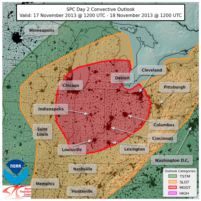
Storm Prediction Center Day 2 Outlook over the Ohio Valley and Great Lakes, showing a Moderate Risk for severe weather.
The potential for rain and an isolated storm will come as a welcomed sight to many in our area. In case you were living under a rock — actually you’d notice there too — it has been very dry in our area. In fact, D1 level drought has been declared across Northern NJ and NYC, with the last significant rain coming on September 22nd. Central Park hasn’t observed a stretch this long without 1″ of rain since the summer of 1999, when NYC went 81 days between 1 inch rainfall events.
After the front passes early on Monday, calmer weather is expected through the middle of next week. Temperatures should return to near seasonal averages.
Great, easy to read report. You guys rock. Thanks.