-2")
Arctic front on the way, heavy rain possible on Wednesday
If you thought today was chilly, just wait until tomorrow. The much-advertised Arctic cold front is on its way, which will bring bitterly cold temperatures, and strong northwest winds. There may be a few scattered snow showers or snow flurries associated with this front, especially north and west of the city.
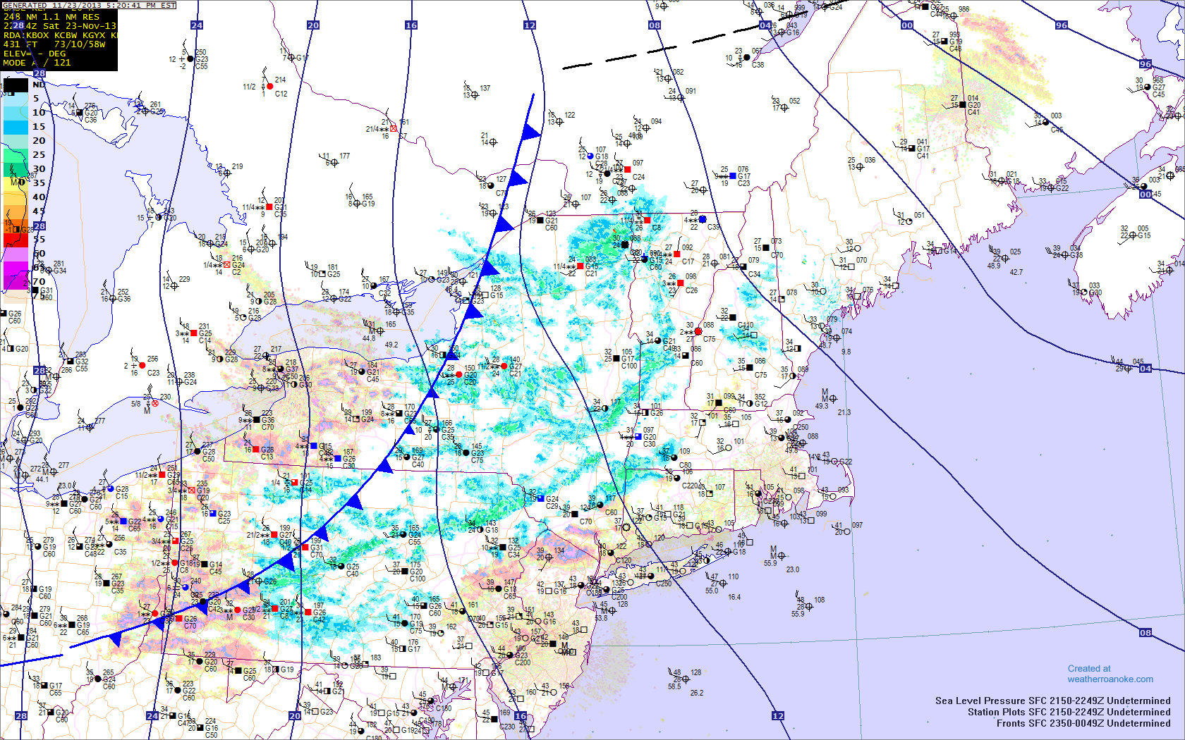
The Arctic front is approaching the region and will be crossing over the next few hours. Temperatures will plummet behind it. Additionally, snow showers can be found, indicated by the blue patches. Any snow showers should primarily remain north and west of the city. Image credit goes to weatherroanoke.com
Any snow showers should primarily remain to the west of the city, given that precipitation tends to dry out once it heads east of the Catskill and Adirondack mountains in a northwest flow. That being said, do not be surprised if a stray snow shower or two does survive a bit further east. Areas in NW Jersey may see a brief period of steady snow covering the ground and reduced visibilities, so any motorists should take caution if they run into this band of snow. Winds will also be gusty, further contributing to any loss in visibility.
Temperatures will drop quickly this evening through the 30s, and our high temperatures tomorrow will actually be occurring at midnight, when temperatures will be in the mid 30s at midnight, and around 30 north and west. They will fall into the upper teens by morning north and west, with wind chills in the single digits, and mid 20s along the coast, with wind chills in the teens. Winds will be sustained between 20-25 miles per hour, with gusts around 35-40 miles per hour. Tomorrow, highs will only be in the upper 20s to lower 30s across the region, as seen in the image below.
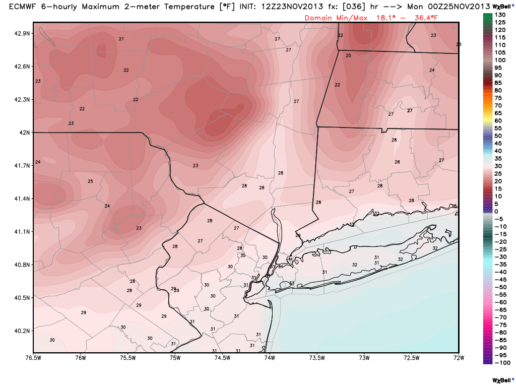
Today’s 12z European model shows temperatures remaining below freezing tomorrow afternoon. Image credit goes to weatherbell.com
Winds will become even stronger tomorrow during the day, with winds sustained between 25 and 30 miles per hour, with gusts as high as 40-50 miles per hour. This will keep wind chills in the teens throughout the entire day. Make sure to bundle up!
This powerful cold front will be ushering in very cold temperatures aloft as well as strong winds aloft, which explains our windy conditions. Below is a forecast model sounding from the NAM model generated from BUFKIT, valid for tomorrow afternoon at LaGuardia Airport.
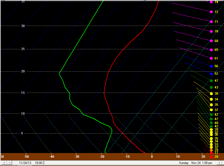
A forecast model sounding at LaGuardia Airport for tomorrow afternoon shows a very unstable atmosphere, helping to generate strong winds.
For people who are newer to soundings, the red line indicates the temperature, the green line indicates the dewpoint, the slanted, dotted blue lines indicate the temperature that they are connected to at the bottom (in Celsius), the numbers on the left are feet above the ground in thousands, and the colored lines on the right indicate wind direction and speed.
Notice how the temperatures are rapidly getting colder with height, especially from the surface through 7,000 feet. This is an indicator of an unstable atmosphere, which helps to generate lift. When there is strong lifting in the atmosphere, a phenomenon that meteorologists like to call “eddies” can develop. Eddies are small circulations which represent lifting going up, and the subsequent “balance” that occurs, as what goes up also comes back down. The faster lifting occurs, the faster and more efficiently the circulation back to the ground occurs, and this is what is important for strong winds.
As this circulation back down is occurring, the atmosphere above the ground can thus mix with the atmosphere closer to the ground. As you can see, there are quite strong winds all throughout that unstable layer, as winds are around 40 knots (46mph) at 7,000 feet. This means that those strong winds will at times be able to mix down to the surface, creating wind gusts at times between 40 and 50 miles per hour. The atmosphere becomes a bit more stable as you head higher up in the atmosphere, so those extremely strong winds near 10,000 feet and higher will not be able to mix down.
What’s also interesting to note is that there appears to be a decent amount of moisture at around 7,000 feet as well. This, combined with the strong lift in the atmosphere may promote a decent amount of clouds, and the strong lifting may actually make some of these clouds cumulus. There does not appear to be enough moisture as a whole for snow, but clouds filtering in at times and a few snow flurries and snow showers cannot be ruled out.
As we head towards tomorrow night, winds will die down a bit, helping to promote more radiational cooling. This will cause overnight lows on Monday morning to be colder than they will be tonight. Low teens can be expected in the interior, with upper teens at the coast, and even at NYC.
Storm Update for Wednesday:
For a more elaborate view on the setup for this storm, you can read our previous article.
Not much has changed since our previous article, as there is still disagreement in modeling data between a rainstorm and a storm that slides out to sea. The European model douses the area with heavy rain, whereas the GFS is out to sea. Ensemble guidance generally leans towards the European solution, so we are leaning towards that for now, but uncertainty still remains.
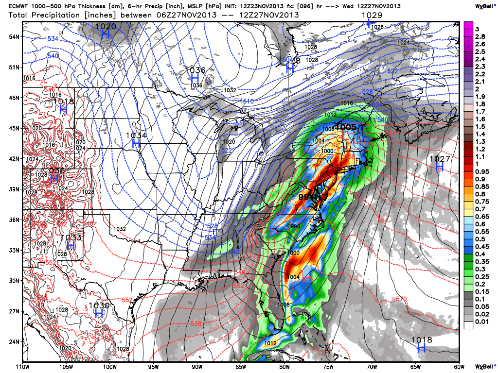
Today’s 12z European model shows a heavy rain event for Tuesday night and Wednesday, tapering off sometime around midnight on Thursday morning. Image credit goes to the WSI Model Lab.
What we are still confident in is the fact that there is not enough blocking for cold air to arrive while most of the precipitation is falling, meaning that this will be a rain event. Perhaps a few snow showers could occur on the back side of the storm when the cold air finally does arrive, especially north and west of the city. But any accumulating snow would be relegated to areas north of I-84, and perhaps even west of I-81.
If the European model were to be correct, 1-2″ of rain could be expected on Wednesday, which is certainly needed considering the drought we are in.
Given the progressive nature of the pattern, there is still the chance that the storm misses entirely. We will be sure to keep you updated as the storm gets closer. Regardless, Thanksgiving looks to be quite cold; perhaps as cold as it will be tomorrow, but it will be dry.
Enjoy the rest of your weekend, everyone!
Leave a Reply
Want to join the discussion?Feel free to contribute!