-2")
Weekend winter storm to bring myriad of threats
The National Weather Service issued Winter Storm Watches on Friday, in advance of a winter storm which is expected to impact the area this weekend. Forecast models have come into better agreement on the evolution of the storm system, which begins in the Central United States on Friday. The storm will track northeastward, as an initial disturbance moves towards the Mississippi Valley. The primary surface low will track towards the Ohio Valley by Saturday morning, before a compressed height field to the north and high pressure over New England force a secondary surface low to redevelop off of the Mid Atlantic coast.
Precipitation is expected to move into the area by late morning on Saturday, with snow beginning to pick up in intensity by early Saturday afternoon. Moderate to heavy snow is expected to continue through Saturday Night. But as warm air advection (the push of warm air towards the area in the mid and low levels via southerly winds) begins to pick up, snow will change over to sleet, freezing rain and quickly rain in areas like Southern New Jersey and Southeast Long Island. Southeast winds off the warmer area waters will not help to keep cold air locked in place along the coastal plain. But inland, deeper cold at the surface will hold on for a longer period of time – meaning a prolonged period of snow. With time, in the area suburbs, the warm air advection will push over the top of the cold air at the surface, changing precipitation to sleet and eventually freezing rain.
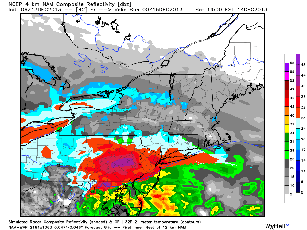
4km NAM simulated radar, showing a period of heavy snow throughout the area on Saturday before a transition to freezing rain and rain.
This suggests the potential for a period of prolonged wintry precipitation across the interior, with areas such as New York City, Long Island, and Coastal New Jersey changing over to rain after a few inches of snow. The impact of the storm system seems likely to be much greater in NYC’s suburbs and interior. Here, several inches of snow (5-7″ or possibly more in Southeast New York and Connecticut) seems likely, followed by a period of sleet and freezing rain. Travel difficulties and hazards seem likely from Saturday into Sunday morning.
There are still some uncertainties in regards to the evolution of the storm. Forecast models remain slightly at odds with the depth of the cold at the surface, and this may have tremendous implications on the eventual outcome of the storm system. A degree or two could make a major difference in this type of situation. Still, model consensus seems to lean towards a major gradient falling near the NYC Area, with much more significant snow occurring
just west of the city, and just a nuisance snowfall event before a changeover to rain to the east of it.
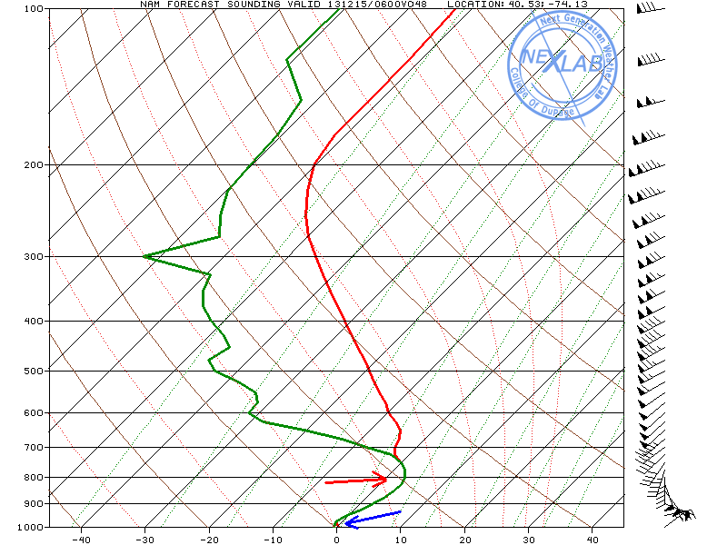
Sounding near Newark NJ from the NAM model, showing a profile of the atmosphere. Note the warm air pushing in around 800mb, but cold air near the surface.
Our official snowfall forecast has been updated to reflect the tightening gradient and increasing confidence. We expect that the National Weather Service will upgrade to a Winter Weather Advisory across much of Central New Jersey, Long Island and New York City later today, with Winter Storm Warnings across the suburbs of NYC and interior. We have additionally upgraded the Storm Briefing which we issued yesterday to reflect the changes to our forecast.
It is important to note that slight changes in the forecast could have large implications on the eventual weather in our area. There is still a good bit of uncertainty with the exact track of this storm system, so stay tuned over the next 24 hours for more information as we continue to analyze the potential. Be sure to stay tuned to our social networks for up to the minute information.

Our latest Storm Total Snowfall Forecast map.
Leave a Reply
Want to join the discussion?Feel free to contribute!