-2")
Cold and dry start to the week, more snow follows
A bitterly cold start to the morning on Monday will serve as a reminder that winter is off to an early start, as if the multiple snow events in the past two weeks weren’t enough. Cold weather is expected to continue throughout the day on Monday as an arctic airmass is settled into much of the Northeast US and New England. High temperatures in the upper 20’s are expected throughout the area on Monday, but it will end up feeling a whole bunch colder than that, thanks to blustery west winds. Real feel temperatures could remain in the teens throughout much of the interior, and maybe even New York City. It will feel a bit warmer close to the immediate coast.
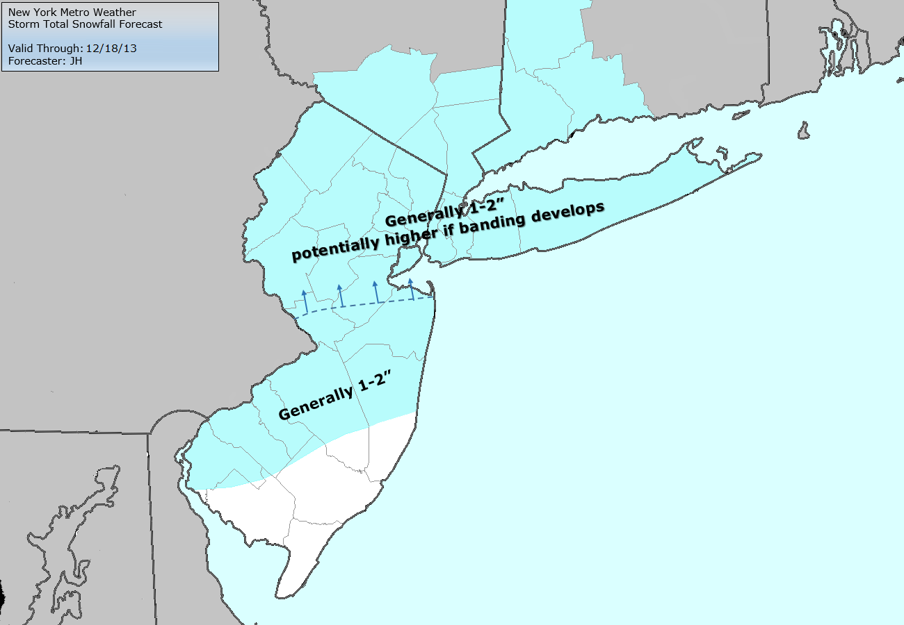
The main story in the upcoming weather period, however, is the clipper system which is expected to deliver another shot of light snow to the area on Tuesday. A surface low associated with a mid and upper level disturbance is forecas to track just south of our area on Monday Night through Tuesday morning. Despite the progressive nature of the pattern, this could cause the development of a weak surface low south of Long Island. And such a development would all but certainly aid in the development of precipitation — likely falling in the form of snow across much of the area — early on Tuesday morning through the afternoon. You can view our latest snowfall forecast here.
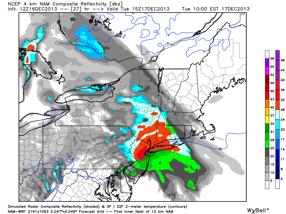
NAM model showing a period of moderate snow throughout the area on Tuesday.
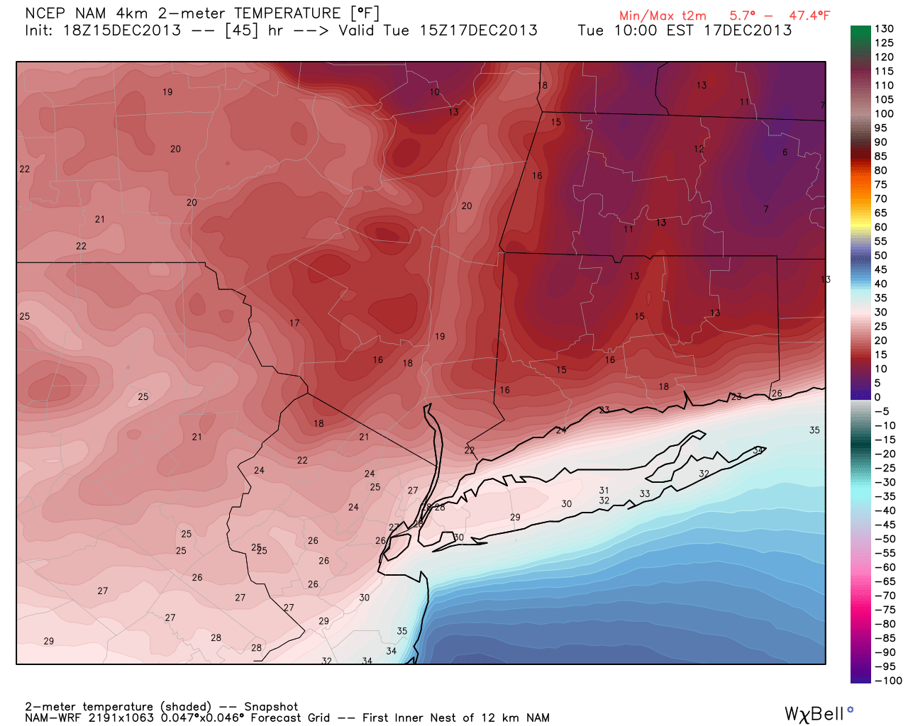
There are still a few concerns with the potential clipper system, however. First, the track of these systems historically trends north or northeast with time. This is something that forecasters in this part of the country can certainly attest to. And the progressive nature of the pattern may argue for less amplification, and a farther north and faster track. Second, the boundary layer remains warm despite the presence of very cold, arctic air aloft. In more simplistic terms, there is still some warm air near the surface despite very cold air well above our heads — it is a problem we will deal with more often than not. Such is life, living by the sea. We can see the warmer boundary layer on the NAM models forecast temperature on Tuesday. This could mean mixed precipitation or even rain near the coast at times during the precipitation. Third, the fast pace of the system leaves little room for error — and so we err on the side of caution when it comes to snowfall accumulations.
In terms of sensible weather, we are forecasting increasing clouds on Tuesday as the system begins to trek towards the area from the Great Lakes. Snow will overspread the region late Monday Night into early Tuesday, beginning light with broken bands of more moderate snow. A burst of more steady moderate snow is possible later on Tuesday morning, with mixed precipitation possible on the shores of New Jersey and Long Island. As the system strengthens slightly in the Atlantic Waters, a burst of moderate snow is also possible over Connecticut and Long Island as the system begins to pull towards Southern New England. The system will begin to pull away by later on Tuesday, but forecast models are already hinting at another disturbance which may keep periods of snow going throughout New Jersey into Wednesday.
Stay tuned over the next several hours into early on Monday, as we continue to analyze new data and information.
Leave a Reply
Want to join the discussion?Feel free to contribute!