-2")
Rain, fog continuing through Monday evening
Periods of rain, with continued spotty areas of dense fog, are expected to persist throughout the day on Monday. The culprit? A low pressure system riding northward up the coast along a frontal boundary. With plenty of moisture available, and warmer than normal air sitting along the coast and throughout much of the Mid Atlantic, widespread rain has developed essentially from the Southeast states into the Northeast US this morning. The rain will continue through much of Monday afternoon, with the areas of fog likely not lifting until later today.
Regional radar imagery this morning showed the bands of moderate to heavy rain continuing to stream up the East Coast. With time, however, the frontal boundary will begin to sag eastward and the heavier rain will follow suit. Cooler air is expected to move into the region by later tonight into Tuesday — as the 70 degree weather from Sunday will quickly become a distant memory. By Christmas day, we will be tracking the potential for bands of snow. More details after the break..
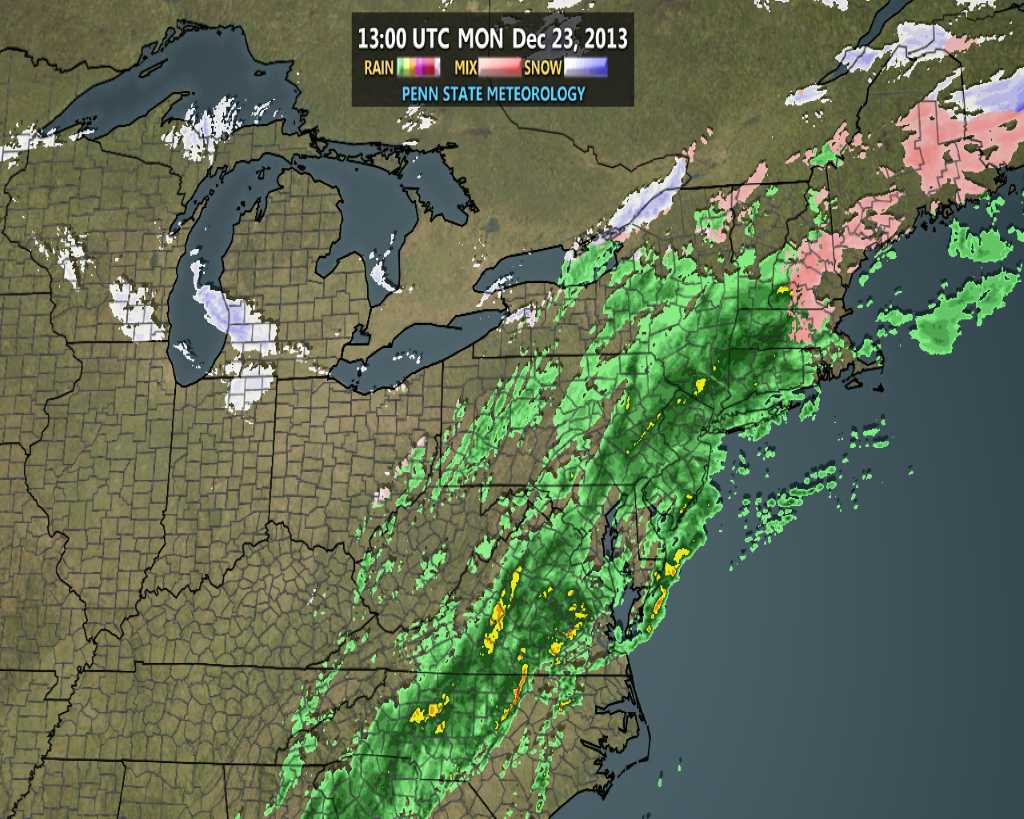
Regional radar imagery from Monday morning, showing areas of moderate to heavy rain moving up the East Coast.
White Christmas possibilities becoming intriguing
Each year it seems, especially in this area, that the possibility of a white Christmas becomes a significant topic of discussion. Usually it is with good reason, as we live in area that doesn’t quite get them “often”, but more often than not seems to have a chance. This year, the chance for a white Christmas seemed all but lost especially if you were to ask anybody their opinion about the topic on Sunday when temperatures reached into the lower 70’s. But the changing pattern will bring dramatic results — and by Sunday a mid level disturbance moving through the area aloft, in association with an upper level low, could bring enough lift and forcing to help develop a band of snow throughout the area.
Forecast models have been quite inconsistent with the band, but that is to be expected. This isn’t a storm system that’s developing — better said, there is no significant or notable area of lower pressure. Instead, it’s a broad area of lower pressure and a specific perturbation aloft that may act among some atmospheric instability to help develop this band of snow. Oddly enough, the usually wildly inconsistent NAM has been the most consistent of all the guidance, indicating a band of moderate to heavy snow (a snow squall, for all intents and purposes) moving from Eastern PA through Northern NJ and NYC on Christmas Day.
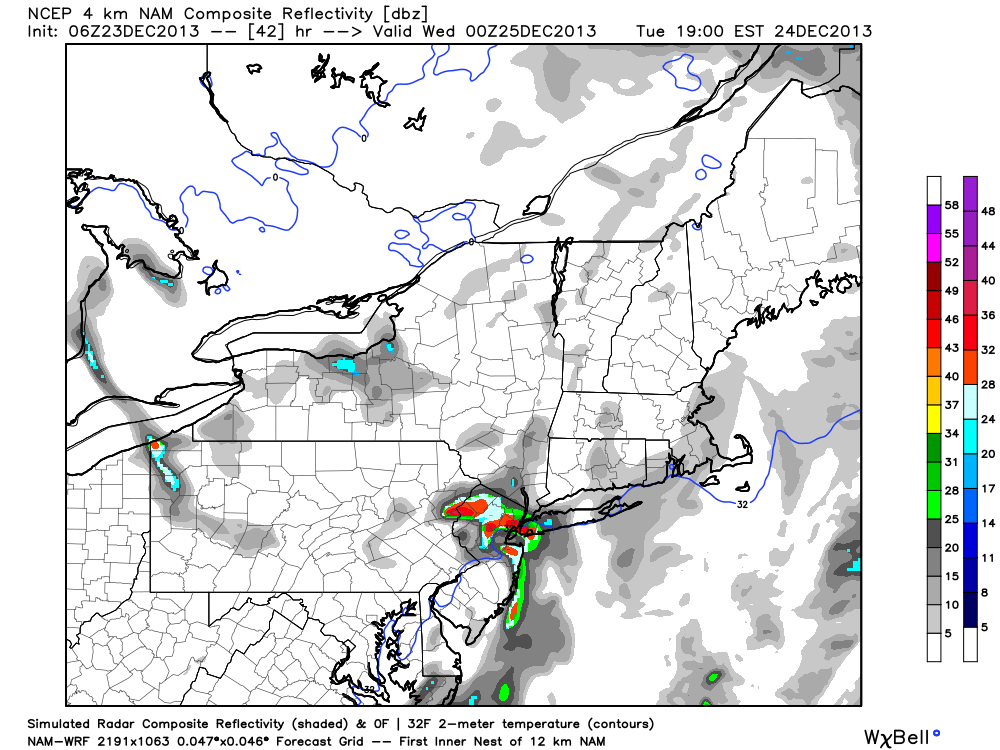
NAM model simulated radar on Christmas Day, showing a small band of heavy snow moving through New Jersey and NYC.
Other models are not so enthused. The GFS doesn’t have much at all — and the Euro has kept the band well farther north, over Southeast New York and parts of Connecticut. We are drawing upon these inconsistencies simply to make a point: this band is exceedingly hard to predict. And we won’t be able to truly predict it until Christmas Day. That being said, forecast models have been very consistent with its development. And the mid level disturbance moving overhead at the time certainly adds credence to that possibility. But the exact location of the band likely won’t be known until a few hours prior to its arrival.
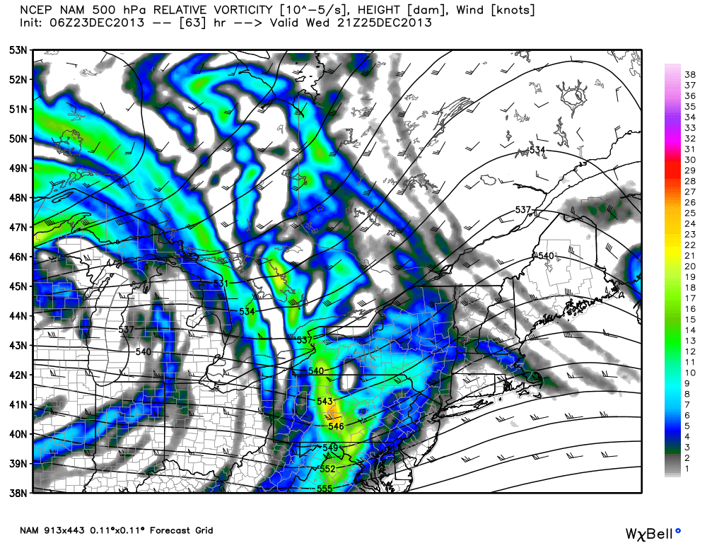
NAM model 500mb height and vorticity, showing a disturbance moving through the area on Christmas Day which may kick off a band of heavy snow.
Underneath the band, wishes will come true, if a white Christmas is what you hoped for. A brief period of moderate to heavy snow is likely with reduced visibilities and light accumulations. The band will be rather quick — in and out within the hour — but it will also serve as a reminder that, despite this weekends warmth, winter is returning. And long range forecast models (which we will discuss in our weekly long range post later today) suggest it will so do with a vengeance.
Leave a Reply
Want to join the discussion?Feel free to contribute!