Understanding the difference between potential and hype

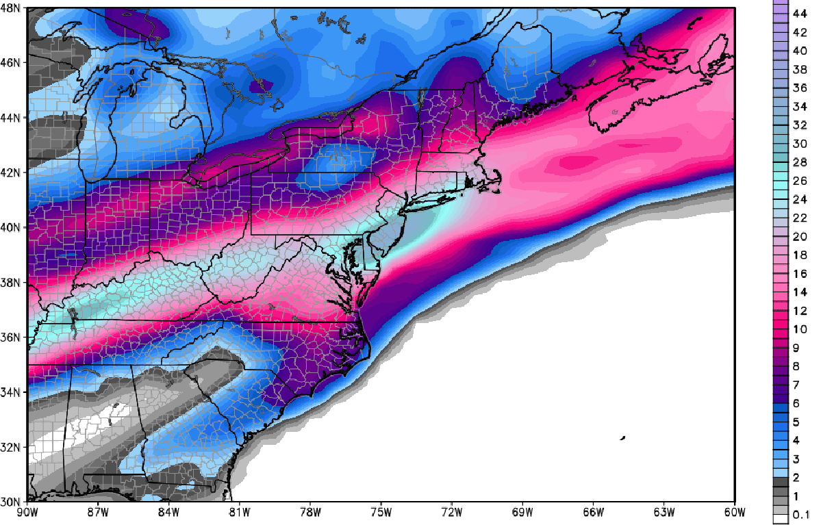
I think I personally hit a bit of a breaking point today. Around 6:00am this morning, we received an inquiry regarding the potential winter weather events next week.  This is nothing terribly unusual — our email inbox is normally filled with these and we do our best to try and answer them and keep people informed. The title of the email read “Information Regarding Blizzard Feb 8” and the contents essentially asked us for our snowfall forecast for the upcoming “Blizzard” which the mailer was under the assumption was going to arrive next week. In the email was a model image, produced by Weatherbell Analytics, which showed the snowfall totals from a ECMWF Ensemble Control run at 200+ hours. It was then that I realized we had a big problem on our hands.

This is nobody’s fault. Not the mailer, nor the company which produced the map. It isn’t our fault, your fault, or any meteorologists. In fact — nobody is to blame. But it is a problem, because the image went viral on social media and many in the general public took it as fact. And so, as meteorologists, it is our job to source back this issue and try to figure out how to avoid it happening again. Similar things have occurred during storms in the past, as recently as a month ago, and the end result is never pretty.

This snowfall total map, which went viral yesterday, is a snowfall forecast from an ensemble member of the ECMWF model.

This snowfall total map, which went viral yesterday, is a snowfall forecast from an ensemble member of the ECMWF model.

Read more

Coastal storm departs, cold air persists

The storm system which brought significant winter weather to the Gulf Coast and Southeast States over the past two days still found a way to scrape our area with light snow from Tuesday Night into Wednesday, with most areas east of the city receiving 1-3″ of fresh powdery snow. Those in Southeast New Jersey, especially Cape May county, will argue that the storm more than “scraped” us — there were multiple reports of over 6″ of snow. But the impacts were especially relegated to the coast this time, as the system headed seaward and banding associated with it battled with dry air farther inland.

Throughout the remainder of today, clearing skies will take over the area’s weather from west to east (with Eastern LI hanging on to some clouds for the longest). Cold air will funnel back in behind the storm system, with blustery west winds becoming noticeable by afternoon. Tonight’s Stadium Series game at Yankee Stadium in the Bronx will feature temperatures in the upper 20’s to teens, with blustery conditions. Bundle up for the game if you’re headed out!

Visible satellite imagery from the morning of Wednesday Jan 29 2014, showing the coastal system departing the area.

Visible satellite imagery from the morning of Wednesday Jan 29 2014, showing the coastal system departing the area.

Read more

Light snow likely tonight for coastal sections

As a major winter storm is hitting the Southeast, model guidance has made subtle shifts to the northwest, showing the storm grazing our area. However, climatologically speaking, a storm that dumps heavy snow to the coastal regions of the Southeast tend to track too far east for major snowfall to our region, which is what will occur this time around.

However, the precipitation shield is pretty expansive — expansive enough to allow some light snow to enter coastal sections late tonight through early tomorrow morning. The further south and east you go, the more likely you are to find a couple of inches of snow.

Today's 18z NAM valid for 4:00am Wednesday morning shows a progressive 500mb pattern, which explains why most of the precipitation will miss out to sea.

Today’s 18z NAM valid for 4:00am Wednesday morning shows a progressive 500mb pattern, which explains why most of the precipitation will miss out to sea.

One reason the precipitation shield becomes so expansive is because of vorticity that streams through the northeast, and vorticity maximum that is streaking through Eastern PA. This helps to tug precipitation back to the west, despite an offshore track. The reason why this storm will not be major snow producer is that the Polar Vortex is pressing down on the pattern a bit too much, giving very little room for our system to amplify — the wave spacing is poor. Thus, we are left with an elongated area of vorticity, which only supports light snow, as opposed to an area that is more consolidated and amplified.

Precipitation looks to start between 8:00 and 9:00pm in South Jersey, and between 10:00pm and 11:00pm for the rest of the region. The snow will primarily be quite light, with perhaps a few brief bursts of moderate snow, before ending between 5:00am and 7:00am tomorrow morning.

Today's 18z NAM valid for 1:00am Wednesday morning shows light snow moving into the region, with heavy snow remaining just offshore. Image credit goes to instantweathermaps.com

Today’s 18z NAM valid for 1:00am Wednesday morning shows light snow moving into the region, with heavy snow remaining just offshore. Image credit goes to instantweathermaps.com

Today’s 18z NAM run gets light snow into the entire region during the overnight tonight. Temperatures will be quite cold throughout the entire atmosphere, so ratios could certainly be around 15:1 or so, but we do not foresee enough lifting in the atmosphere for ratios to exceed 20:1. Dry air will be quite prevalent on the northwest side of the system, so snowfall cutoffs will be quite sharp, and moderate to heavy precipitation will have a tough time advancing too far northward.

Our snowfall forecast map can be seen below:

Our snowfall forecast map for tonight's light snow event.

Our snowfall forecast map for tonight’s light snow event.

There is a chance that we may have to bump up parts of SE NJ and E LI into the 2-4″ range, however, since based on the subtle modeling trends, more precipitation may be able to sneak into eastern sections of the region. Although the large-scale weather pattern is not favorable for a major snow event, there is still enough uncertainty to warrant the chances of a 25-mile shift to the northwest, which could put places like Cape May County in a zone of even a 3-5″ potential. This would also shift the 1-3″ line back towards Southern Middlesex County and through Queens and parts of NYC. NYC itself should not get more than 2″, even in the “snowiest case scenario.”

Regardless, this event will still have to be watched closely, and we will keep you updated.


Cold weather continues, storms offshore

For the greater part of the past month, the weather has featured below normal temperatures with occasional precipitation — and much of the same will continue. We’ve experienced two or more “significant” winter weather events, but for now, the pattern looks to continue to feature the aforementioned cold temperatures while significant precipitation events tend to avoid our area. Although this will eventually change when the amplitude of the trough axis over the Northeast US decreases somewhat, we’re not expecting much of a change in the forthcoming work week.

Monday, a system passes to our north with the low pressure center actually tracking through Northern New England. A cold front will approach our area by the afternoon hours and west winds will usher in another cold airmass. The only other noteworthy weather event in the coming week will be a southern stream disturbance which will slide off the Southeast Coast. But forecast models are in good agreement on the fact that the developing surface low will head seaward — well too far south and east of our area for any impacts in terms of sensible weather. Some light precipitation may ultimately graze the area coasts should the track of the storm end up farther north and west of current guidance.

GFS model indicating a low pressure system passing off the coast on Wednesday -- too far south and east for impacts in our area.

GFS model indicating a low pressure system passing off the coast on Wednesday — too far south and east for impacts in our area.

Super Bowl event should be light, but may feature mixed precipitation: In a similar fashion to the parade of clipper systems which we have experienced over the past few weeks, forecast models are indicating a pattern change which will allow for frequent precipitation events emerging from the south and west of our forecast area. The first looks to impact the area during the upcoming weekend — in fact from Saturday into Sunday — and may impact the Super Bowl and associated activities.

That being said, guidance is still very inconsistent with timing and precipitation impacts. The general idea, however, is for a low pressure system to shift front the MS Valley into the Northeast US. What remains uncertain is how quickly it does so, and how much warm air advection pushes north through our area. This will determine when the heaviest precipitation falls, and whether it falls as frozen precipitation or the warm air takes over and results in rain.

Over the next few days we will feature the super bowl forecast for free in each of our daily posts, with updates on the latest information.